Perryton Topo Map Ohio
To zoom in, hover over the map of Perryton
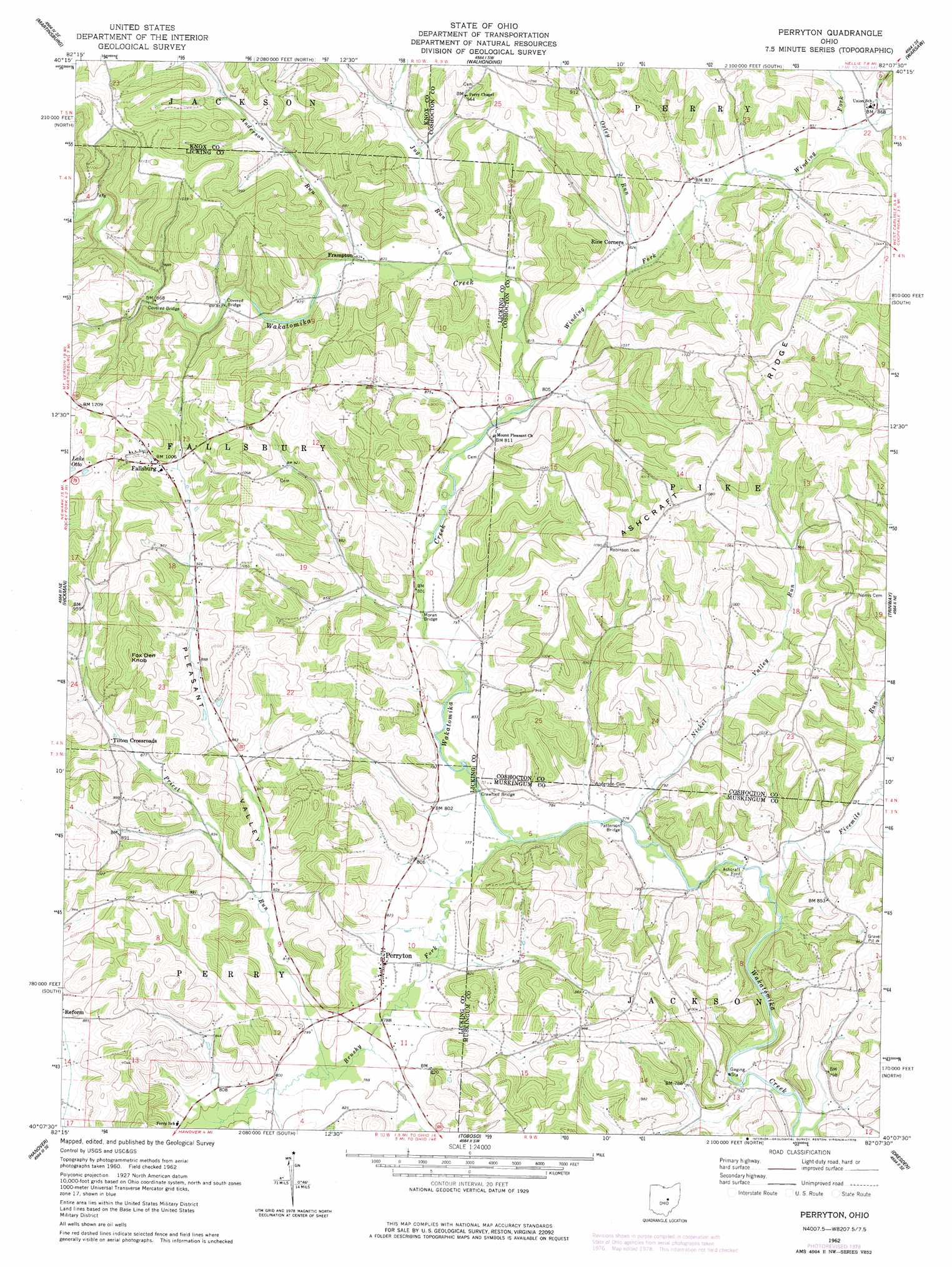
USGS Topo Quad 40082b2 - 1:24,000 scale
| Topo Map Name: | Perryton |
| USGS Topo Quad ID: | 40082b2 |
| Print Size: | ca. 21 1/4" wide x 27" high |
| Southeast Coordinates: | 40.125° N latitude / 82.125° W longitude |
| Map Center Coordinates: | 40.1875° N latitude / 82.1875° W longitude |
| U.S. State: | OH |
| Filename: | o40082b2.jpg |
| Download Map JPG Image: | Perryton topo map 1:24,000 scale |
| Map Type: | Topographic |
| Topo Series: | 7.5´ |
| Map Scale: | 1:24,000 |
| Source of Map Images: | United States Geological Survey (USGS) |
| Alternate Map Versions: |
Perryton OH 1962, updated 1963 Download PDF Buy paper map Perryton OH 1962, updated 1978 Download PDF Buy paper map Perryton OH 1962, updated 1978 Download PDF Buy paper map Perryton OH 2010 Download PDF Buy paper map Perryton OH 2013 Download PDF Buy paper map Perryton OH 2016 Download PDF Buy paper map |
1:24,000 Topo Quads surrounding Perryton
Mount Vernon |
Danville |
Brinkhaven |
Spring Mountain |
Killbuck |
Hunt |
Martinsburg |
Walhonding |
Warsaw |
Randle |
Utica |
Hickman |
Perryton |
Trinway |
Conesville |
Newark |
Hanover |
Toboso |
Dresden |
Adamsville |
Thornville |
Glenford |
Gratiot |
Zanesville West |
Zanesville East |
> Back to 40082a1 at 1:100,000 scale
> Back to 40082a1 at 1:250,000 scale
> Back to U.S. Topo Maps home
Perryton topo map: Gazetteer
Perryton: Bridges
Crawford Bridge elevation 237m 777′Gregg Mill Bridge elevation 261m 856′
Moran Bridge elevation 239m 784′
Patterson Bridge elevation 231m 757′
Perryton: Crossings
Ashcraft Ford elevation 234m 767′Perryton: Populated Places
Fallsburg elevation 302m 990′Frampton elevation 252m 826′
Perryton elevation 244m 800′
Tilton Crossroads elevation 273m 895′
Perryton: Post Offices
Fallsburg Post Office (historical) elevation 303m 994′Frampton Post Office (historical) elevation 257m 843′
Perryton Post Office (historical) elevation 246m 807′
Perryton: Ridges
Ashcraft Ridge elevation 329m 1079′Perryton: Streams
Anderson Run elevation 250m 820′Brushy Fork elevation 233m 764′
Fivemile Run elevation 231m 757′
Jug Run elevation 246m 807′
Nickel Valley Run elevation 231m 757′
Oxley Run elevation 275m 902′
Priest Run elevation 238m 780′
Winding Fork elevation 244m 800′
Perryton: Summits
Fox Den Knob elevation 366m 1200′Perryton: Valleys
Pleasant Valley elevation 248m 813′Perryton digital topo map on disk
Buy this Perryton topo map showing relief, roads, GPS coordinates and other geographical features, as a high-resolution digital map file on DVD:
 map DVD")