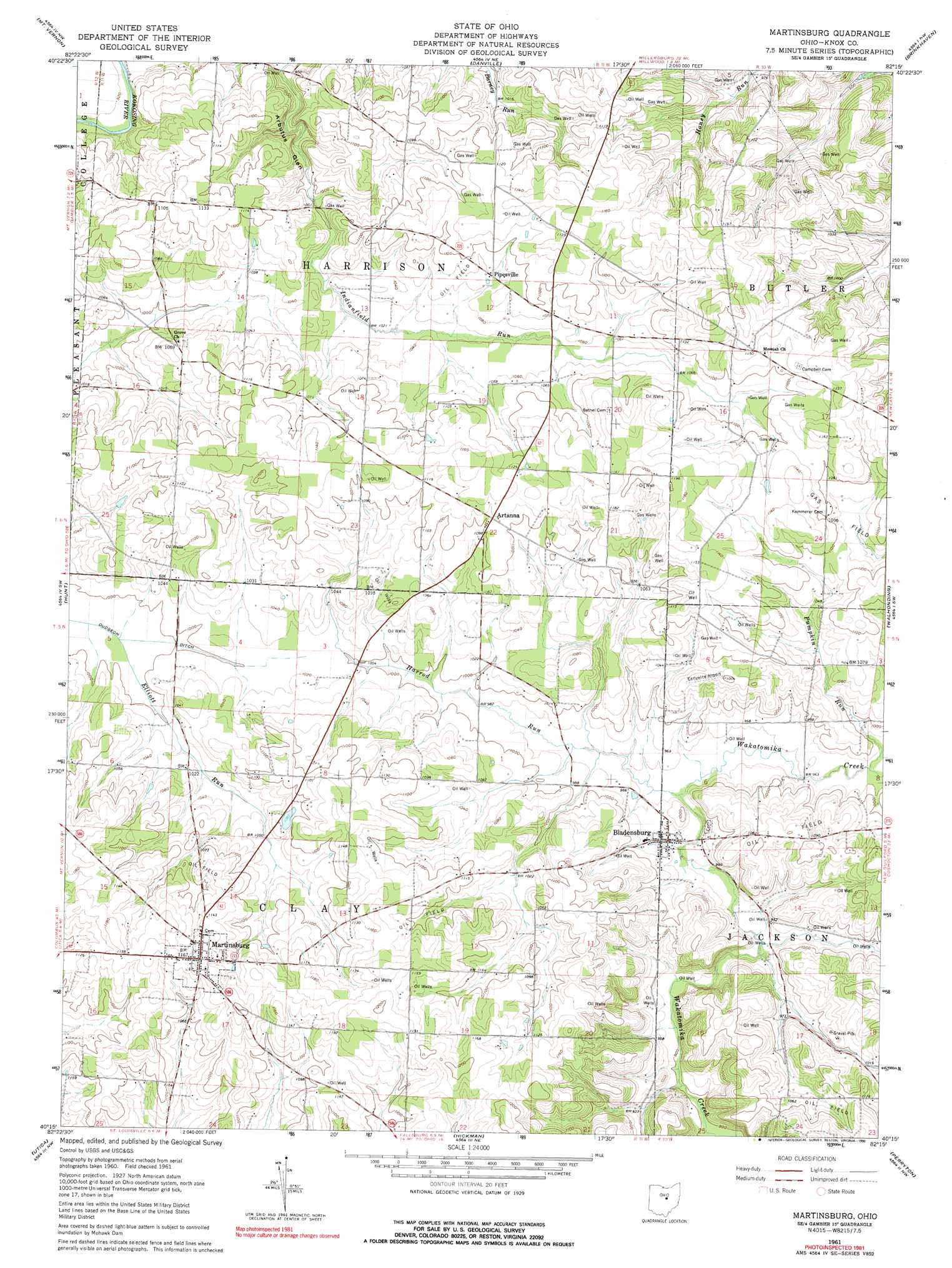
Martinsburg Topo Map Ohio
To zoom in, hover over the map of Martinsburg
USGS Topo Quad 40082c3 - 1:24,000 scale
| Topo Map Name: | Martinsburg |
| USGS Topo Quad ID: | 40082c3 |
| Print Size: | ca. 21 1/4" wide x 27" high |
| Southeast Coordinates: | 40.25° N latitude / 82.25° W longitude |
| Map Center Coordinates: | 40.3125° N latitude / 82.3125° W longitude |
| U.S. State: | OH |
| Filename: | o40082c3.jpg |
| Download Map JPG Image: | Martinsburg topo map 1:24,000 scale |
| Map Type: | Topographic |
| Topo Series: | 7.5´ |
| Map Scale: | 1:24,000 |
| Source of Map Images: | United States Geological Survey (USGS) |
| Alternate Map Versions: |
Martinsburg OH 1961, updated 1975 Download PDF Buy paper map Martinsburg OH 1961, updated 1975 Download PDF Buy paper map Martinsburg OH 1961, updated 1990 Download PDF Buy paper map Martinsburg OH 2010 Download PDF Buy paper map Martinsburg OH 2013 Download PDF Buy paper map Martinsburg OH 2016 Download PDF Buy paper map |
1:24,000 Topo Quads surrounding Martinsburg
Bellville |
Butler |
Jelloway |
Greer |
Glenmont |
Fredericktown |
Mount Vernon |
Danville |
Brinkhaven |
Spring Mountain |
Homer |
Hunt |
Martinsburg |
Walhonding |
Warsaw |
Fredonia |
Utica |
Hickman |
Perryton |
Trinway |
Granville |
Newark |
Hanover |
Toboso |
Dresden |
> Back to 40082a1 at 1:100,000 scale
> Back to 40082a1 at 1:250,000 scale
> Back to U.S. Topo Maps home
Martinsburg topo map: Gazetteer
Martinsburg: Airports
Earlywine Airport elevation 330m 1082′Martinsburg: Bridges
Mill Road Bowstring Bridge elevation 316m 1036′Martinsburg: Canals
Dudgeon Ditch elevation 302m 990′Martinsburg: Populated Places
Artanna elevation 338m 1108′Bladensburg elevation 293m 961′
Front Royal (historical) elevation 302m 990′
Martinsburg elevation 358m 1174′
Pipesville elevation 328m 1076′
Martinsburg: Post Offices
Bladensburg Post Office elevation 294m 964′Martinsburg Post Office elevation 358m 1174′
Pipesville Post Office (historical) elevation 327m 1072′
Martinsburg: Streams
Elliott Run elevation 301m 987′Harrod Run elevation 290m 951′
Pleasant Valley Run elevation 280m 918′
Pumpkin Run elevation 294m 964′
Tomaky Branch elevation 293m 961′
Martinsburg: Valleys
Arbutus Glen elevation 286m 938′Martinsburg digital topo map on disk
Buy this Martinsburg topo map showing relief, roads, GPS coordinates and other geographical features, as a high-resolution digital map file on DVD:
 map DVD")