Kilbourne Topo Map Ohio
To zoom in, hover over the map of Kilbourne
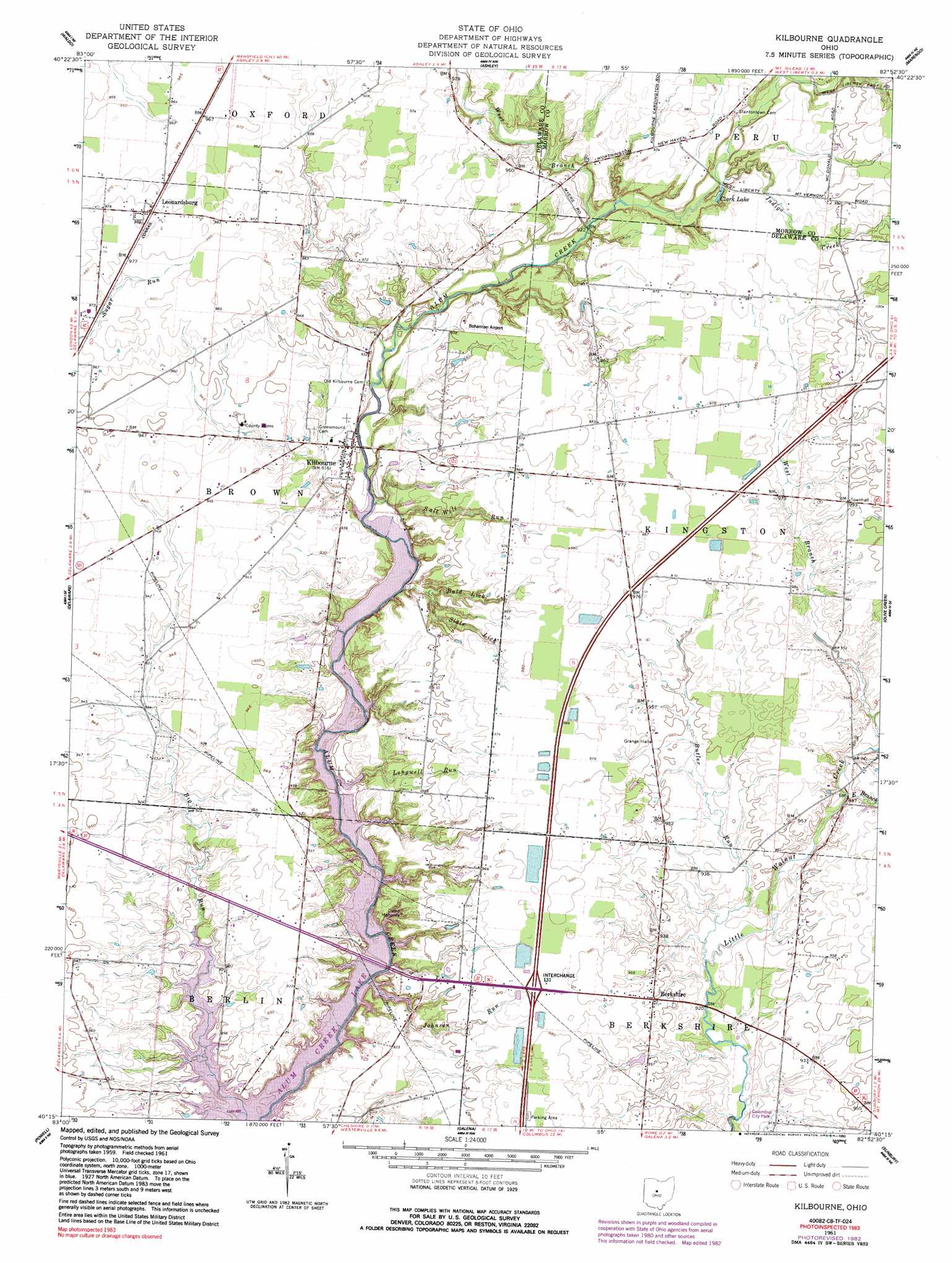
USGS Topo Quad 40082c8 - 1:24,000 scale
| Topo Map Name: | Kilbourne |
| USGS Topo Quad ID: | 40082c8 |
| Print Size: | ca. 21 1/4" wide x 27" high |
| Southeast Coordinates: | 40.25° N latitude / 82.875° W longitude |
| Map Center Coordinates: | 40.3125° N latitude / 82.9375° W longitude |
| U.S. State: | OH |
| Filename: | o40082c8.jpg |
| Download Map JPG Image: | Kilbourne topo map 1:24,000 scale |
| Map Type: | Topographic |
| Topo Series: | 7.5´ |
| Map Scale: | 1:24,000 |
| Source of Map Images: | United States Geological Survey (USGS) |
| Alternate Map Versions: |
Kilbourne OH 1961, updated 1962 Download PDF Buy paper map Kilbourne OH 1961, updated 1973 Download PDF Buy paper map Kilbourne OH 1961, updated 1983 Download PDF Buy paper map Kilbourne OH 1961, updated 1990 Download PDF Buy paper map Kilbourne OH 2010 Download PDF Buy paper map Kilbourne OH 2013 Download PDF Buy paper map Kilbourne OH 2016 Download PDF Buy paper map |
1:24,000 Topo Quads surrounding Kilbourne
Marion West |
Marion East |
Denmark |
Mount Gilead |
Shauck |
Prospect |
Waldo |
Ashley |
Marengo |
Chesterville |
Ostrander |
Delaware |
Kilbourne |
Olive Green |
Centerburg |
Shawnee Hills |
Powell |
Galena |
Sunbury |
Johnstown |
Hilliard |
Northwest Columbus |
Northeast Columbus |
New Albany |
Jersey |
> Back to 40082a1 at 1:100,000 scale
> Back to 40082a1 at 1:250,000 scale
> Back to U.S. Topo Maps home
Kilbourne topo map: Gazetteer
Kilbourne: Airports
Bohannan Airport elevation 293m 961′Davis Family Airport elevation 288m 944′
Kilbourne: Crossings
Interchange 131 elevation 299m 980′Kilbourne: Lakes
Clark Lake elevation 286m 938′Kilbourne: Parks
Columbus City Park elevation 281m 921′Kilbourne: Populated Places
Alum Creek elevation 287m 941′Berkshire elevation 290m 951′
Kilbourne elevation 280m 918′
Kingston Center elevation 302m 990′
Leonardsburg elevation 299m 980′
Kilbourne: Post Offices
Alum Creek Post Office (historical) elevation 288m 944′Berkshire Post Office (historical) elevation 289m 948′
Kilbourne Post Office elevation 281m 921′
Kingston Center Post Office (historical) elevation 303m 994′
Leonardsburg Post Office (historical) elevation 300m 984′
Kilbourne: Streams
Bald Lick elevation 270m 885′Butler Run elevation 277m 908′
East Branch Little Walnut Creek elevation 283m 928′
Indigo Creek elevation 282m 925′
Johnson Run elevation 262m 859′
Longwell Run elevation 265m 869′
Salt Well Run elevation 275m 902′
Slate Lick elevation 271m 889′
West Branch Alum Creek elevation 277m 908′
West Branch Little Walnut Creek elevation 287m 941′
Kilbourne digital topo map on disk
Buy this Kilbourne topo map showing relief, roads, GPS coordinates and other geographical features, as a high-resolution digital map file on DVD:
 map DVD")