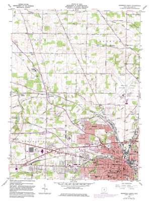
Mansfield North Topo Map Ohio
To zoom in, hover over the map of Mansfield North
USGS Topo Quad 40082g5 - 1:24,000 scale
| Topo Map Name: | Mansfield North |
| USGS Topo Quad ID: | 40082g5 |
| Print Size: | ca. 21 1/4" wide x 27" high |
| Southeast Coordinates: | 40.75° N latitude / 82.5° W longitude |
| Map Center Coordinates: | 40.8125° N latitude / 82.5625° W longitude |
| U.S. State: | OH |
| Filename: | o40082g5.jpg |
| Download Map JPG Image: | Mansfield North topo map 1:24,000 scale |
| Map Type: | Topographic |
| Topo Series: | 7.5´ |
| Map Scale: | 1:24,000 |
| Source of Map Images: | United States Geological Survey (USGS) |
| Alternate Map Versions: |
Mansfield North OH 1960, updated 1962 Download PDF Buy paper map Mansfield North OH 1960, updated 1973 Download PDF Buy paper map Mansfield North OH 1960, updated 1975 Download PDF Buy paper map Mansfield North OH 1960, updated 1983 Download PDF Buy paper map Mansfield North OH 2010 Download PDF Buy paper map Mansfield North OH 2013 Download PDF Buy paper map Mansfield North OH 2016 Download PDF Buy paper map |
1:24,000 Topo Quads surrounding Mansfield North
> Back to 40082e1 at 1:100,000 scale
> Back to 40082a1 at 1:250,000 scale
> Back to U.S. Topo Maps home
Mansfield North topo map: Gazetteer
Mansfield North: Airports
Au Heliport elevation 393m 1289′Bahl Helistop elevation 408m 1338′
Manairco Heliport elevation 387m 1269′
Mansfield CPC Heliport elevation 426m 1397′
Mansfield General Hospital Heliport elevation 406m 1332′
Mansfield Lahm Municipal Airport elevation 394m 1292′
Westbrook Heliport elevation 411m 1348′
Mansfield North: Lakes
Walker Lake elevation 389m 1276′Mansfield North: Parks
Airport Park elevation 396m 1299′Arlin Field Stadium elevation 386m 1266′
Central Park elevation 378m 1240′
Hamilton Park elevation 374m 1227′
Hedges School Park elevation 391m 1282′
Johns Park elevation 377m 1236′
Middle Park elevation 373m 1223′
North Lake Park elevation 363m 1190′
Sherman Heneman Park elevation 400m 1312′
South Park elevation 391m 1282′
Taylor Field elevation 377m 1236′
Mansfield North: Populated Places
Amoy elevation 383m 1256′Briarwood Estates Mobile Home Park elevation 391m 1282′
Dale Avenue Mobile Home Park elevation 392m 1286′
Mansfield elevation 379m 1243′
Maybee elevation 427m 1400′
Midpoint Woods elevation 392m 1286′
Myers (historical) elevation 353m 1158′
Ontario elevation 414m 1358′
Roseland elevation 372m 1220′
Spring Grove (historical) elevation 357m 1171′
Spring Mill elevation 373m 1223′
Stewart (historical) elevation 415m 1361′
Sunnyview elevation 398m 1305′
Taylortown elevation 359m 1177′
Toledo Junction elevation 369m 1210′
Woodside Estates Mobile Home Park elevation 392m 1286′
Mansfield North: Post Offices
Amoy Post Office (historical) elevation 384m 1259′Mansfield Post Office elevation 373m 1223′
Ontario Post Office elevation 415m 1361′
Mansfield North: Streams
Touby Run elevation 347m 1138′Mansfield North digital topo map on disk
Buy this Mansfield North topo map showing relief, roads, GPS coordinates and other geographical features, as a high-resolution digital map file on DVD:


