Plumwood Topo Map Ohio
To zoom in, hover over the map of Plumwood
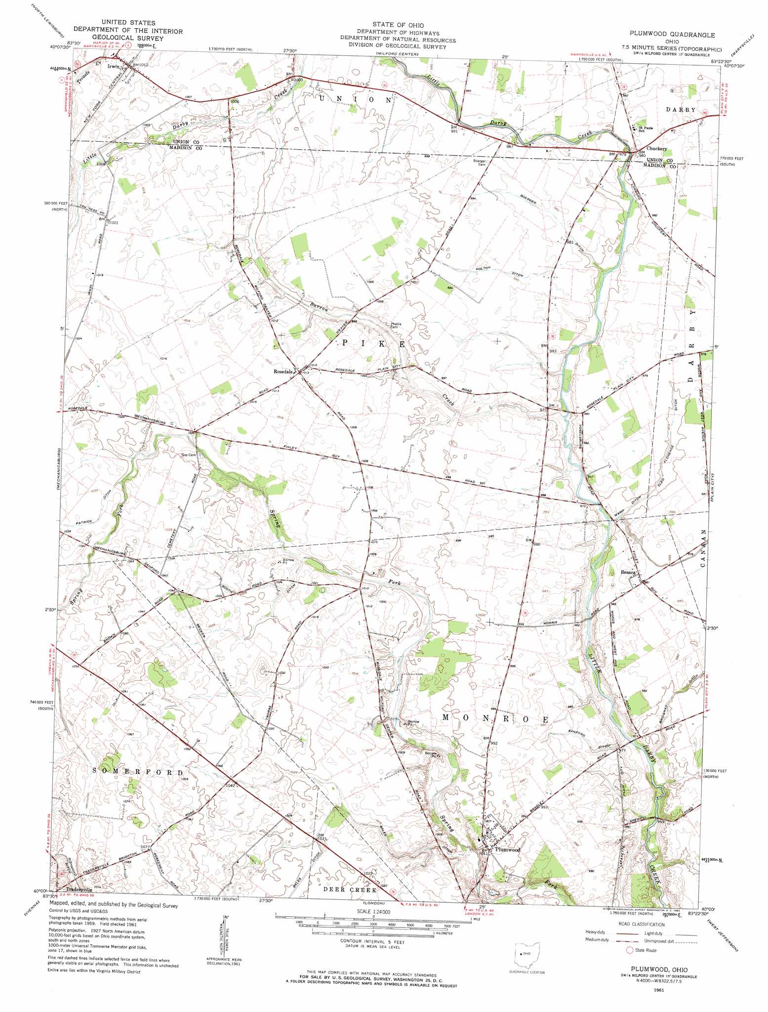
USGS Topo Quad 40083a4 - 1:24,000 scale
| Topo Map Name: | Plumwood |
| USGS Topo Quad ID: | 40083a4 |
| Print Size: | ca. 21 1/4" wide x 27" high |
| Southeast Coordinates: | 40° N latitude / 83.375° W longitude |
| Map Center Coordinates: | 40.0625° N latitude / 83.4375° W longitude |
| U.S. State: | OH |
| Filename: | o40083a4.jpg |
| Download Map JPG Image: | Plumwood topo map 1:24,000 scale |
| Map Type: | Topographic |
| Topo Series: | 7.5´ |
| Map Scale: | 1:24,000 |
| Source of Map Images: | United States Geological Survey (USGS) |
| Alternate Map Versions: |
Plumwood OH 1961, updated 1962 Download PDF Buy paper map Plumwood OH 2010 Download PDF Buy paper map Plumwood OH 2013 Download PDF Buy paper map Plumwood OH 2016 Download PDF Buy paper map |
1:24,000 Topo Quads surrounding Plumwood
Zanesfield |
East Liberty |
Peoria |
Magnetic Springs |
Ostrander |
Kingscreek |
North Lewisburg |
Milford Center |
Marysville |
Shawnee Hills |
Urbana East |
Mechanicsburg |
Plumwood |
Plain City |
Hilliard |
New Moorefield |
South Vienna |
London |
West Jefferson |
Galloway |
South Charleston |
Florence |
Walnut Run |
Big Plain |
Harrisburg |
> Back to 40083a1 at 1:100,000 scale
> Back to 40082a1 at 1:250,000 scale
> Back to U.S. Topo Maps home
Plumwood topo map: Gazetteer
Plumwood: Areas
Bigelow Cemetery Prairie elevation 302m 990′Plumwood: Bridges
Little Darby Bridge elevation 297m 974′Plumwood: Canals
Bales Ditch elevation 311m 1020′Boerger Ditch elevation 300m 984′
Booth Ditch elevation 311m 1020′
Bridgeman Ditch elevation 294m 964′
Cleo Florence Ditch elevation 295m 967′
Holton Ditch elevation 302m 990′
Patrick Ditch elevation 315m 1033′
Sanford Ditch elevation 298m 977′
Wamp Ditch elevation 294m 964′
Plumwood: Parks
Bigelow Cemetery State Nature Preserve elevation 302m 990′Plumwood: Populated Places
Chuckery elevation 299m 980′Irwin elevation 308m 1010′
Plumwood elevation 307m 1007′
Resaca elevation 299m 980′
Rosedale elevation 308m 1010′
Plumwood: Post Offices
Chuckery Post Office (historical) elevation 299m 980′Irwin Post Office elevation 308m 1010′
Plumwood Post Office (historical) elevation 307m 1007′
Resaca Post Office (historical) elevation 299m 980′
Rosedale Post Office (historical) elevation 308m 1010′
Plumwood: Streams
Barron Creek elevation 294m 964′Plumwood digital topo map on disk
Buy this Plumwood topo map showing relief, roads, GPS coordinates and other geographical features, as a high-resolution digital map file on DVD:
 map DVD")