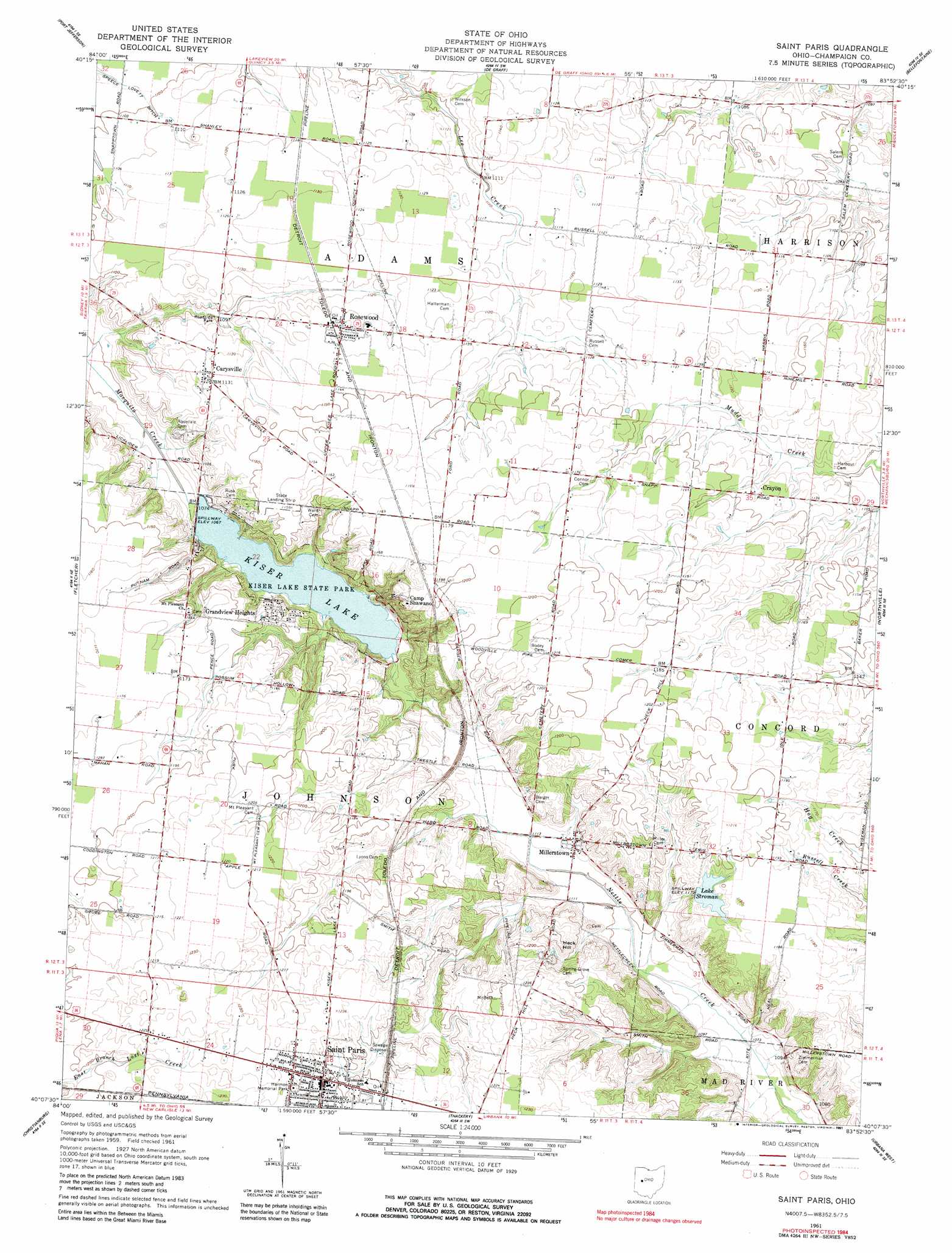
Saint Paris Topo Map Ohio
To zoom in, hover over the map of Saint Paris
USGS Topo Quad 40083b8 - 1:24,000 scale
| Topo Map Name: | Saint Paris |
| USGS Topo Quad ID: | 40083b8 |
| Print Size: | ca. 21 1/4" wide x 27" high |
| Southeast Coordinates: | 40.125° N latitude / 83.875° W longitude |
| Map Center Coordinates: | 40.1875° N latitude / 83.9375° W longitude |
| U.S. State: | OH |
| Filename: | o40083b8.jpg |
| Download Map JPG Image: | Saint Paris topo map 1:24,000 scale |
| Map Type: | Topographic |
| Topo Series: | 7.5´ |
| Map Scale: | 1:24,000 |
| Source of Map Images: | United States Geological Survey (USGS) |
| Alternate Map Versions: |
Saint Paris OH 1961, updated 1962 Download PDF Buy paper map Saint Paris OH 1961, updated 1991 Download PDF Buy paper map Saint Paris OH 2010 Download PDF Buy paper map Saint Paris OH 2013 Download PDF Buy paper map Saint Paris OH 2016 Download PDF Buy paper map |
1:24,000 Topo Quads surrounding Saint Paris
Botkins |
Jackson Center |
Russells Point |
Huntsville |
Rushsylvania |
Sidney |
Port Jefferson |
De Graff |
Bellefontaine |
Zanesfield |
Piqua East |
Fletcher |
Saint Paris |
Northville |
Kingscreek |
Troy |
Christiansburg |
Thackery |
Urbana West |
Urbana East |
Tipp City |
New Carlisle |
Donnelsville |
Springfield |
New Moorefield |
> Back to 40083a1 at 1:100,000 scale
> Back to 40082a1 at 1:250,000 scale
> Back to U.S. Topo Maps home
Saint Paris topo map: Gazetteer
Saint Paris: Canals
Speece Lovett Ditch elevation 333m 1092′Saint Paris: Dams
Kiser Lake Dam elevation 326m 1069′Stroman Lake Dam elevation 357m 1171′
Saint Paris: Islands
Ground Hog Island elevation 325m 1066′Saint Paris: Parks
Davey Woods Nature Preserve elevation 341m 1118′Harmon Memorial Park elevation 372m 1220′
Kiser Lake State Park elevation 332m 1089′
Kiser Lake Wetlands Nature Preserve elevation 325m 1066′
Saint Paris: Populated Places
Carysville elevation 344m 1128′Crayon elevation 348m 1141′
Grandview Heights elevation 336m 1102′
Millerstown elevation 339m 1112′
Rosewood elevation 346m 1135′
Saint Paris elevation 368m 1207′
Saint Paris: Post Offices
Carysville Post Office (historical) elevation 344m 1128′Crayon Post Office (historical) elevation 347m 1138′
Darnell Post Office (historical) elevation 347m 1138′
Millerstown Post Office (historical) elevation 339m 1112′
Rosewood Post Office elevation 345m 1131′
Saint Paris Post Office elevation 368m 1207′
Saint Paris: Reservoirs
Kiser Lake elevation 326m 1069′Lake Stroman elevation 357m 1171′
Saint Paris: Summits
Heck Hill elevation 365m 1197′Saint Paris: Swamps
Mosquito Lake Bog (historical) elevation 323m 1059′Saint Paris: Trails
North Bay Trail elevation 327m 1072′Possum Hollow Trail elevation 354m 1161′
Saint Paris digital topo map on disk
Buy this Saint Paris topo map showing relief, roads, GPS coordinates and other geographical features, as a high-resolution digital map file on DVD:
 map DVD")