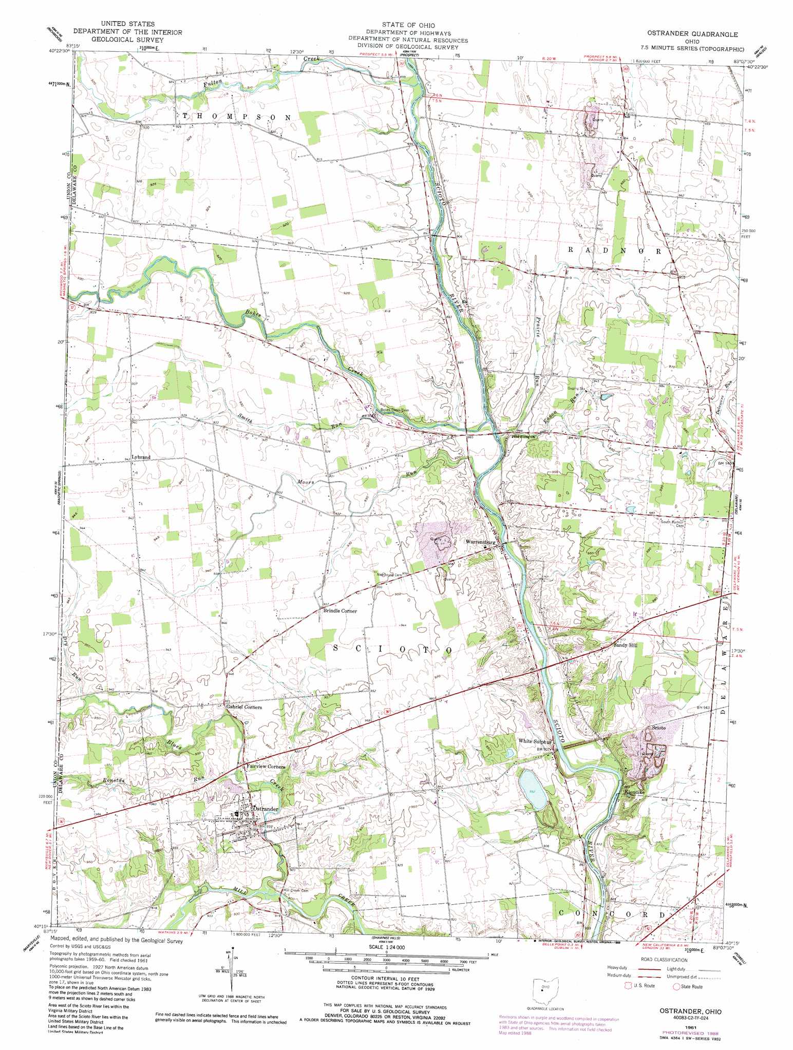
Ostrander Topo Map Ohio
To zoom in, hover over the map of Ostrander
USGS Topo Quad 40083c2 - 1:24,000 scale
| Topo Map Name: | Ostrander |
| USGS Topo Quad ID: | 40083c2 |
| Print Size: | ca. 21 1/4" wide x 27" high |
| Southeast Coordinates: | 40.25° N latitude / 83.125° W longitude |
| Map Center Coordinates: | 40.3125° N latitude / 83.1875° W longitude |
| U.S. State: | OH |
| Filename: | o40083c2.jpg |
| Download Map JPG Image: | Ostrander topo map 1:24,000 scale |
| Map Type: | Topographic |
| Topo Series: | 7.5´ |
| Map Scale: | 1:24,000 |
| Source of Map Images: | United States Geological Survey (USGS) |
| Alternate Map Versions: |
Ostrander OH 1961, updated 1962 Download PDF Buy paper map Ostrander OH 1961, updated 1973 Download PDF Buy paper map Ostrander OH 1961, updated 1988 Download PDF Buy paper map Ostrander OH 2010 Download PDF Buy paper map Ostrander OH 2013 Download PDF Buy paper map Ostrander OH 2016 Download PDF Buy paper map |
1:24,000 Topo Quads surrounding Ostrander
La Rue |
New Bloomington |
Marion West |
Marion East |
Denmark |
York Center |
Richwood |
Prospect |
Waldo |
Ashley |
Peoria |
Magnetic Springs |
Ostrander |
Delaware |
Kilbourne |
Milford Center |
Marysville |
Shawnee Hills |
Powell |
Galena |
Plumwood |
Plain City |
Hilliard |
Northwest Columbus |
Northeast Columbus |
> Back to 40083a1 at 1:100,000 scale
> Back to 40082a1 at 1:250,000 scale
> Back to U.S. Topo Maps home
Ostrander topo map: Gazetteer
Ostrander: Airports
Mill Creek Airport elevation 290m 951′Ostrander: Bridges
Bellefontaine bridge elevation 265m 869′Ostrander: Populated Places
Brindle Corner elevation 283m 928′Fairview Corners elevation 282m 925′
Klondike elevation 263m 862′
Lybrand elevation 287m 941′
Ostrander elevation 284m 931′
Sandy Hill elevation 292m 958′
Scioto elevation 286m 938′
Warrensburg elevation 268m 879′
White Sulphur elevation 276m 905′
Ostrander: Post Offices
Lybrand Post Office (historical) elevation 287m 941′Ostrander Post Office elevation 282m 925′
Warrensburg Post Office (historical) elevation 268m 879′
White Sulphur Post Office (historical) elevation 273m 895′
Ostrander: Streams
Blues Creek elevation 273m 895′Bokes Creek elevation 265m 869′
Dry Run elevation 282m 925′
Dun Run elevation 274m 898′
Eagon Run elevation 267m 875′
Fulton Creek elevation 271m 889′
Moors Run elevation 265m 869′
Prairie Run elevation 264m 866′
Ronolds Run elevation 277m 908′
Smith Run elevation 273m 895′
Ostrander digital topo map on disk
Buy this Ostrander topo map showing relief, roads, GPS coordinates and other geographical features, as a high-resolution digital map file on DVD:
 map DVD")