Huntsville Topo Map Ohio
To zoom in, hover over the map of Huntsville
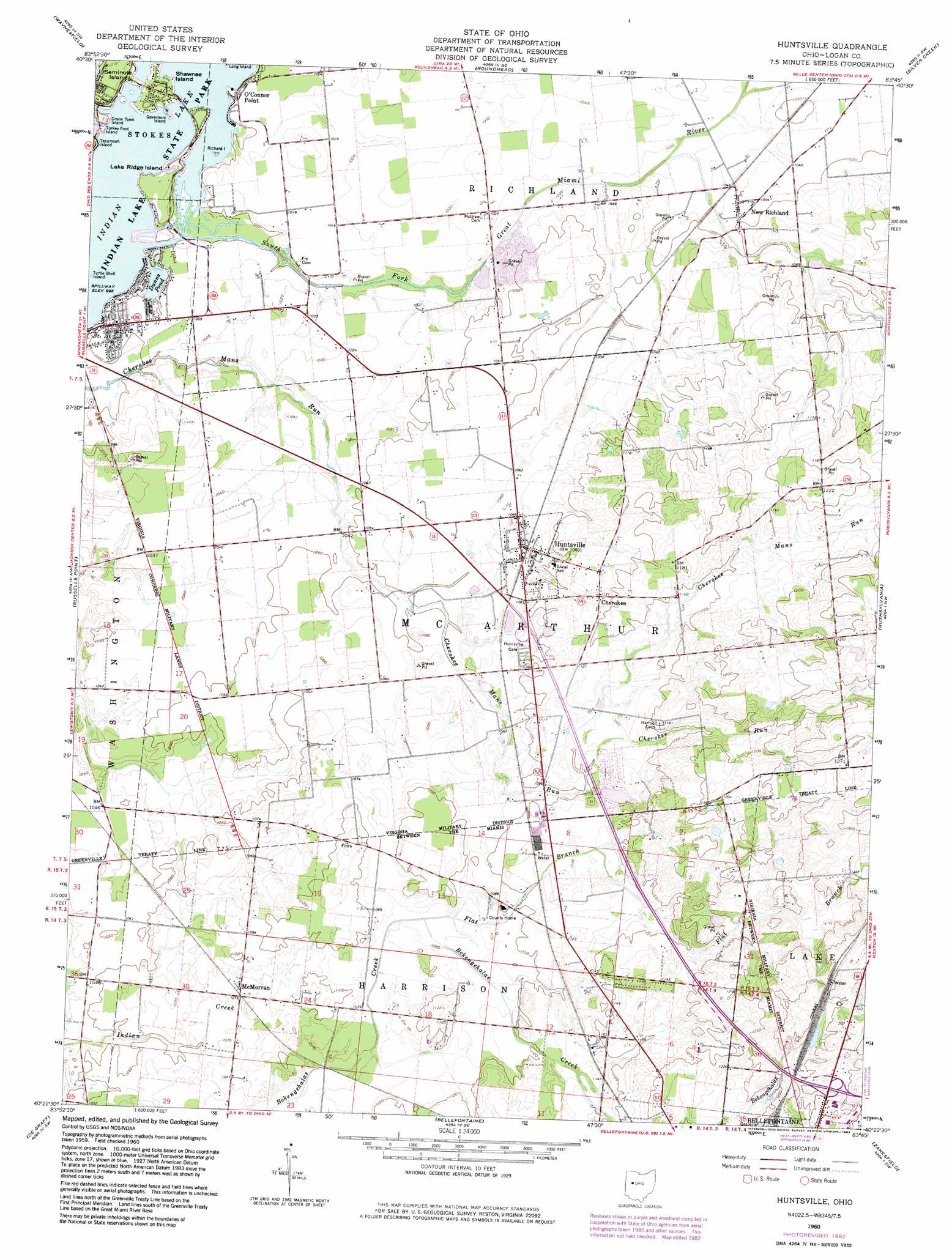
USGS Topo Quad 40083d7 - 1:24,000 scale
| Topo Map Name: | Huntsville |
| USGS Topo Quad ID: | 40083d7 |
| Print Size: | ca. 21 1/4" wide x 27" high |
| Southeast Coordinates: | 40.375° N latitude / 83.75° W longitude |
| Map Center Coordinates: | 40.4375° N latitude / 83.8125° W longitude |
| U.S. State: | OH |
| Filename: | o40083d7.jpg |
| Download Map JPG Image: | Huntsville topo map 1:24,000 scale |
| Map Type: | Topographic |
| Topo Series: | 7.5´ |
| Map Scale: | 1:24,000 |
| Source of Map Images: | United States Geological Survey (USGS) |
| Alternate Map Versions: |
Huntsville OH 1960, updated 1962 Download PDF Buy paper map Huntsville OH 1960, updated 1974 Download PDF Buy paper map Huntsville OH 1960, updated 1983 Download PDF Buy paper map Huntsville OH 2010 Download PDF Buy paper map Huntsville OH 2013 Download PDF Buy paper map Huntsville OH 2016 Download PDF Buy paper map |
1:24,000 Topo Quads surrounding Huntsville
Lima |
Harrod |
Alger |
Foraker |
Kenton |
Uniopolis |
Waynesfield |
Roundhead |
Silver Creek |
Mount Victory |
Jackson Center |
Russells Point |
Huntsville |
Rushsylvania |
West Mansfield |
Port Jefferson |
De Graff |
Bellefontaine |
Zanesfield |
East Liberty |
Fletcher |
Saint Paris |
Northville |
Kingscreek |
North Lewisburg |
> Back to 40083a1 at 1:100,000 scale
> Back to 40082a1 at 1:250,000 scale
> Back to U.S. Topo Maps home
Huntsville topo map: Gazetteer
Huntsville: Airports
Mary Rutan Heliport elevation 410m 1345′Huntsville: Bridges
Bickham Bridge elevation 305m 1000′Huntsville: Dams
Bell Pond Dam elevation 338m 1108′Huntsville: Islands
Crane Town Island elevation 305m 1000′Governors Island elevation 304m 997′
Lake Ridge Island elevation 306m 1003′
Richard Island elevation 304m 997′
Shawnee Island elevation 305m 1000′
Turkey Foot Island elevation 305m 1000′
Turtle Shell Island elevation 302m 990′
Huntsville: Parks
Indian Lake State Park elevation 304m 997′Huntsville: Populated Places
Cherokee elevation 348m 1141′Huntsville elevation 329m 1079′
McMorran elevation 327m 1072′
New Richland elevation 318m 1043′
O'Connor Point elevation 305m 1000′
Huntsville: Post Offices
Huntsville Post Office elevation 326m 1069′New Richland Post Office (historical) elevation 317m 1040′
Huntsville: Reservoirs
Bell Pond elevation 338m 1108′Dunns Pond elevation 305m 1000′
Huntsville: Streams
Cherokee Run elevation 335m 1099′Flat Branch elevation 326m 1069′
South Fork Great Miami River elevation 304m 997′
Huntsville digital topo map on disk
Buy this Huntsville topo map showing relief, roads, GPS coordinates and other geographical features, as a high-resolution digital map file on DVD:
 map DVD")