Russells Point Topo Map Ohio
To zoom in, hover over the map of Russells Point
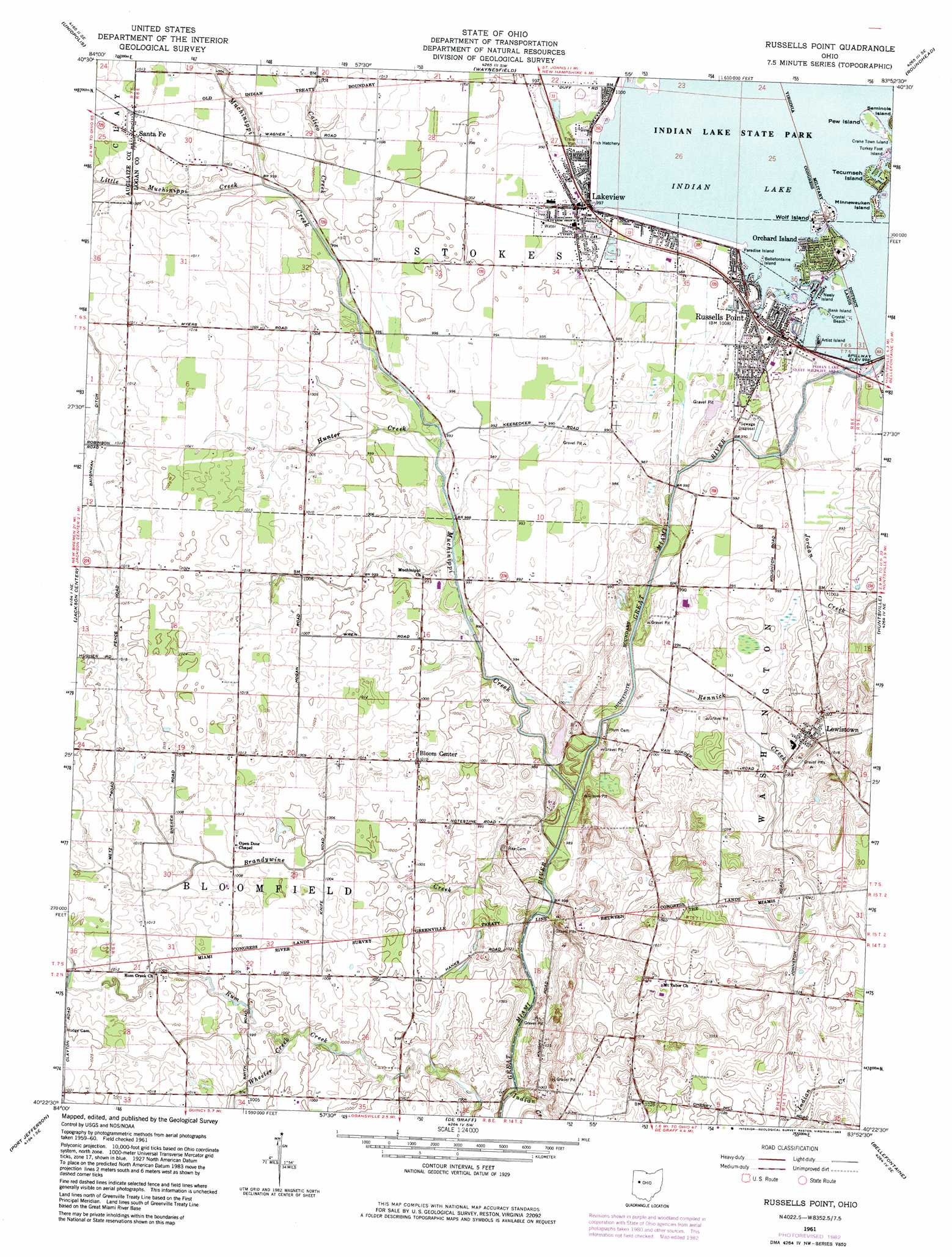
USGS Topo Quad 40083d8 - 1:24,000 scale
| Topo Map Name: | Russells Point |
| USGS Topo Quad ID: | 40083d8 |
| Print Size: | ca. 21 1/4" wide x 27" high |
| Southeast Coordinates: | 40.375° N latitude / 83.875° W longitude |
| Map Center Coordinates: | 40.4375° N latitude / 83.9375° W longitude |
| U.S. State: | OH |
| Filename: | o40083d8.jpg |
| Download Map JPG Image: | Russells Point topo map 1:24,000 scale |
| Map Type: | Topographic |
| Topo Series: | 7.5´ |
| Map Scale: | 1:24,000 |
| Source of Map Images: | United States Geological Survey (USGS) |
| Alternate Map Versions: |
Russells Point OH 1961, updated 1963 Download PDF Buy paper map Russells Point OH 1961, updated 1974 Download PDF Buy paper map Russells Point OH 1961, updated 1983 Download PDF Buy paper map Russells Point OH 2010 Download PDF Buy paper map Russells Point OH 2013 Download PDF Buy paper map Russells Point OH 2016 Download PDF Buy paper map |
1:24,000 Topo Quads surrounding Russells Point
Cridersville |
Lima |
Harrod |
Alger |
Foraker |
Wapakoneta |
Uniopolis |
Waynesfield |
Roundhead |
Silver Creek |
Botkins |
Jackson Center |
Russells Point |
Huntsville |
Rushsylvania |
Sidney |
Port Jefferson |
De Graff |
Bellefontaine |
Zanesfield |
Piqua East |
Fletcher |
Saint Paris |
Northville |
Kingscreek |
> Back to 40083a1 at 1:100,000 scale
> Back to 40082a1 at 1:250,000 scale
> Back to U.S. Topo Maps home
Russells Point topo map: Gazetteer
Russells Point: Bridges
McColly Bridge elevation 297m 974′Russells Point: Canals
Baughman Ditch elevation 306m 1003′Russells Point: Dams
Indian Lake Dam elevation 301m 987′Russells Point: Islands
Artist Island elevation 303m 994′Bank Island elevation 303m 994′
Bellefontaine Island elevation 306m 1003′
Crystal Beach elevation 302m 990′
Minnewauken Island elevation 304m 997′
Neely Island elevation 304m 997′
Paradise Island elevation 305m 1000′
Pew Island elevation 304m 997′
Tecumseh Island elevation 305m 1000′
Winnewauken Island elevation 304m 997′
Wolf Island elevation 305m 1000′
Russells Point: Parks
Fox Island State Park elevation 303m 994′Indian Lake State Wildlife Area elevation 301m 987′
Russells Point: Populated Places
Bloom Center elevation 308m 1010′Lakeview elevation 303m 994′
Lewistown elevation 310m 1017′
Mount Tabor (historical) elevation 312m 1023′
Muchinippi (historical) elevation 302m 990′
Orchard Island elevation 306m 1003′
Russells Point elevation 306m 1003′
Santa Fe elevation 308m 1010′
Russells Point: Post Offices
Bloom Center Post Office (historical) elevation 308m 1010′Lakeview Post Office elevation 302m 990′
Lewistown Post Office elevation 310m 1017′
Muchinipee Post Office (historical) elevation 302m 990′
Orchard Island Post Office (historical) elevation 306m 1003′
Russels Point Post Office (historical) elevation 306m 1003′
Santa Fe Post Office (historical) elevation 308m 1010′
Russells Point: Streams
Brandywine Creek elevation 297m 974′Calico Creek elevation 300m 984′
Cherokee Mans Run elevation 299m 980′
Indian Creek elevation 297m 974′
Jordan Creek elevation 300m 984′
Little Muchinippi Creek elevation 301m 987′
Muchinippi Creek elevation 299m 980′
Rennick Creek elevation 297m 974′
Wheeler Creek elevation 302m 990′
Russells Point digital topo map on disk
Buy this Russells Point topo map showing relief, roads, GPS coordinates and other geographical features, as a high-resolution digital map file on DVD:
 map DVD")