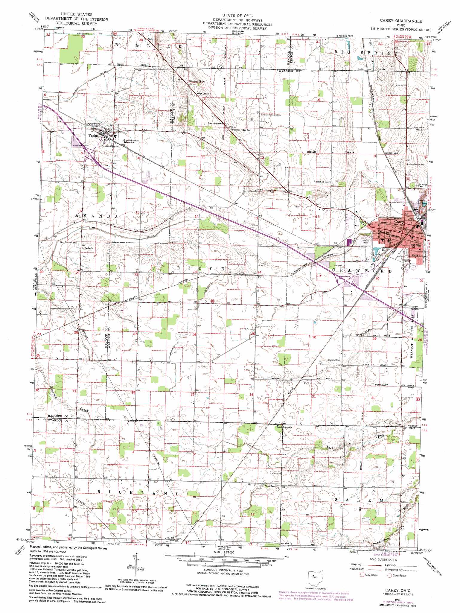
Carey Topo Map Ohio
To zoom in, hover over the map of Carey
USGS Topo Quad 40083h4 - 1:24,000 scale
| Topo Map Name: | Carey |
| USGS Topo Quad ID: | 40083h4 |
| Print Size: | ca. 21 1/4" wide x 27" high |
| Southeast Coordinates: | 40.875° N latitude / 83.375° W longitude |
| Map Center Coordinates: | 40.9375° N latitude / 83.4375° W longitude |
| U.S. State: | OH |
| Filename: | o40083h4.jpg |
| Download Map JPG Image: | Carey topo map 1:24,000 scale |
| Map Type: | Topographic |
| Topo Series: | 7.5´ |
| Map Scale: | 1:24,000 |
| Source of Map Images: | United States Geological Survey (USGS) |
| Alternate Map Versions: |
Carey OH 1961, updated 1962 Download PDF Buy paper map Carey OH 1961, updated 1973 Download PDF Buy paper map Carey OH 1961, updated 1980 Download PDF Buy paper map Carey OH 2010 Download PDF Buy paper map Carey OH 2013 Download PDF Buy paper map Carey OH 2016 Download PDF Buy paper map |
1:24,000 Topo Quads surrounding Carey
North Baltimore |
Bloomdale |
Fostoria |
Bascom |
Tiffin North |
Findlay |
Arcadia |
Alvada |
New Riegel |
Tiffin South |
Arlington |
Mount Blanchard |
Carey |
Mccutchenville |
Sycamore |
Dunkirk |
Forest |
Wharton |
Upper Sandusky |
Nevada |
Foraker |
Kenton |
Marseilles |
Meeker |
Morral |
> Back to 40083e1 at 1:100,000 scale
> Back to 40082a1 at 1:250,000 scale
> Back to U.S. Topo Maps home
Carey topo map: Gazetteer
Carey: Airports
Tong Farm Airport elevation 255m 836′Carey: Canals
Bacher Ditch elevation 260m 853′Number Thirtytwo Ditch elevation 251m 823′
Carey: Parks
Memorial Park elevation 252m 826′Shrine Park elevation 253m 830′
Wyandot Wildlife Area elevation 250m 820′
Carey: Populated Places
Carey elevation 250m 820′Carey Mobile Home Park elevation 249m 816′
Vanlue elevation 251m 823′
Carey: Post Offices
Carey Post Office elevation 251m 823′Vanlue Post Office elevation 251m 823′
Carey: Ridges
North Ridge elevation 268m 879′Carey digital topo map on disk
Buy this Carey topo map showing relief, roads, GPS coordinates and other geographical features, as a high-resolution digital map file on DVD:
 map DVD")