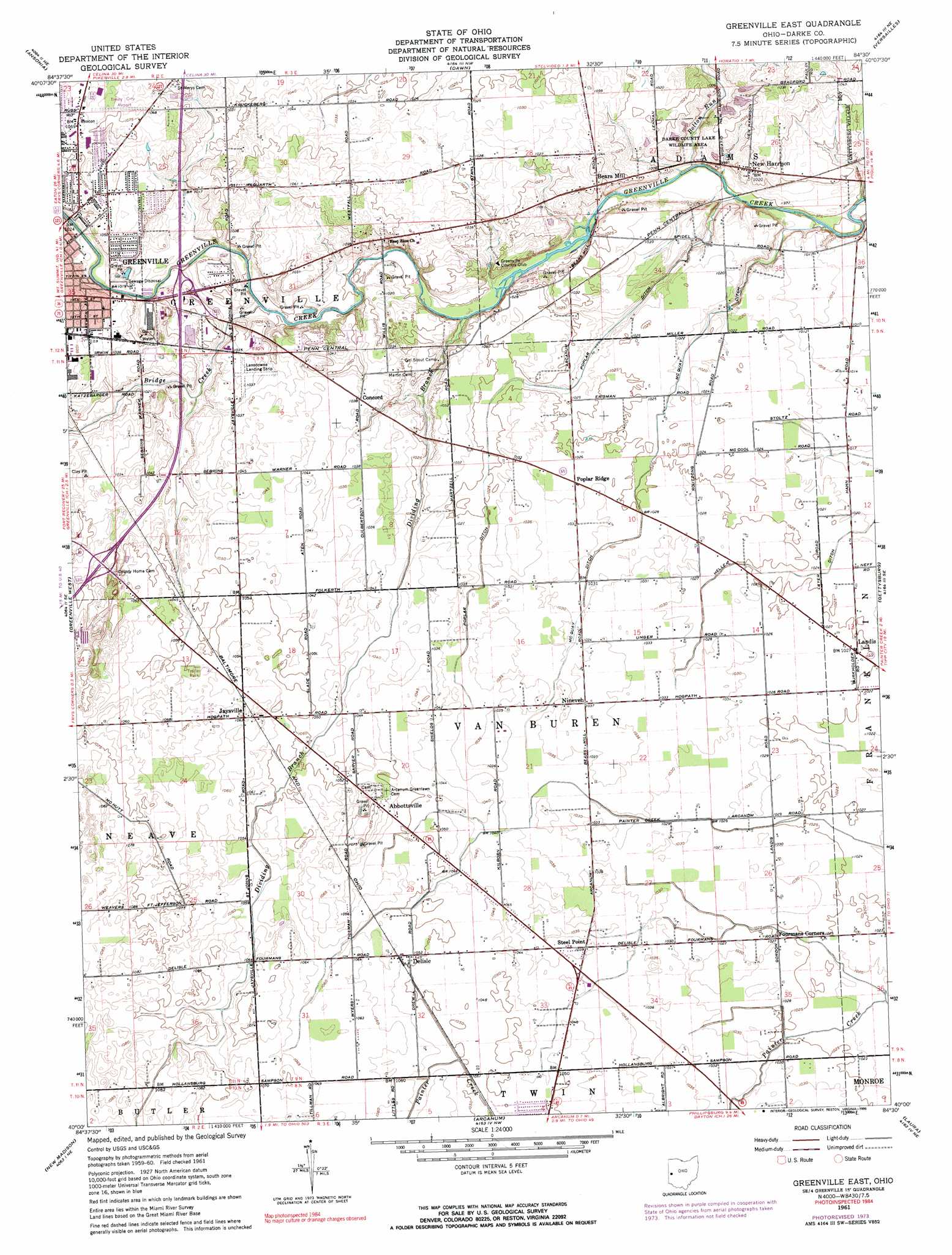
Greenville East Topo Map Ohio
To zoom in, hover over the map of Greenville East
USGS Topo Quad 40084a5 - 1:24,000 scale
| Topo Map Name: | Greenville East |
| USGS Topo Quad ID: | 40084a5 |
| Print Size: | ca. 21 1/4" wide x 27" high |
| Southeast Coordinates: | 40° N latitude / 84.5° W longitude |
| Map Center Coordinates: | 40.0625° N latitude / 84.5625° W longitude |
| U.S. State: | OH |
| Filename: | o40084a5.jpg |
| Download Map JPG Image: | Greenville East topo map 1:24,000 scale |
| Map Type: | Topographic |
| Topo Series: | 7.5´ |
| Map Scale: | 1:24,000 |
| Source of Map Images: | United States Geological Survey (USGS) |
| Alternate Map Versions: |
Greenville East OH 1961, updated 1962 Download PDF Buy paper map Greenville East OH 1961, updated 1974 Download PDF Buy paper map Greenville East OH 1961, updated 1990 Download PDF Buy paper map Greenville East OH 2010 Download PDF Buy paper map Greenville East OH 2013 Download PDF Buy paper map Greenville East OH 2016 Download PDF Buy paper map |
1:24,000 Topo Quads surrounding Greenville East
Cosmos |
Rossburg |
North Star |
Osgood |
Fort Loramie |
Union City |
Ansonia |
Dawn |
Versailles |
Piqua West |
Spartanburg |
Greenville West |
Greenville East |
Gettysburg |
Pleasant Hill |
Whitewater |
New Madison |
Arcanum |
Laura |
West Milton |
New Paris |
Eaton North |
Lewisburg |
Brookville |
Trotwood |
> Back to 40084a1 at 1:100,000 scale
> Back to 40084a1 at 1:250,000 scale
> Back to U.S. Topo Maps home
Greenville East topo map: Gazetteer
Greenville East: Airports
Baker Landing Field elevation 313m 1026′Lansdowne Landing Strip elevation 315m 1033′
Treaty City Airport elevation 326m 1069′
Greenville East: Canals
Heller Ditch elevation 310m 1017′McQuay Ditch elevation 311m 1020′
Poplar Ditch elevation 312m 1023′
Greenville East: Dams
Darke Company Lake Wildlife Area Pond Five Dam elevation 304m 997′Greenville East: Parks
Darke County Lake Wildlife Area elevation 300m 984′Routzong Preserve elevation 312m 1023′
Greenville East: Populated Places
Abbottsville elevation 326m 1069′Bears Mill elevation 311m 1020′
Concord elevation 316m 1036′
Delisle elevation 321m 1053′
Fourmans Corners elevation 313m 1026′
Jaysville elevation 323m 1059′
Landis elevation 313m 1026′
New Harrison elevation 311m 1020′
Nineveh elevation 317m 1040′
Poplar Ridge elevation 314m 1030′
Sampson (historical) elevation 326m 1069′
Steel Point elevation 316m 1036′
Greenville East: Post Offices
Abbottsville Post Office (historical) elevation 324m 1062′Delisle Post Office (historical) elevation 320m 1049′
Jaysville Post Office (historical) elevation 324m 1062′
Landis Post Office (historical) elevation 312m 1023′
New Harrison Post Office (historical) elevation 311m 1020′
Poplar Ridge Post Office (historical) elevation 314m 1030′
Sampson Post Office (historical) elevation 326m 1069′
Greenville East: Reservoirs
Darke Company Lake Wildlife Area Pond elevation 304m 997′Greenville East: Streams
Bolton Run elevation 298m 977′Bridge Creek elevation 305m 1000′
Dividing Branch elevation 303m 994′
Greenville East digital topo map on disk
Buy this Greenville East topo map showing relief, roads, GPS coordinates and other geographical features, as a high-resolution digital map file on DVD:
Northern Illinois, Northern Indiana & Southwestern Michigan
Buy digital topo maps: Northern Illinois, Northern Indiana & Southwestern Michigan