Spartanburg Topo Map Indiana
To zoom in, hover over the map of Spartanburg
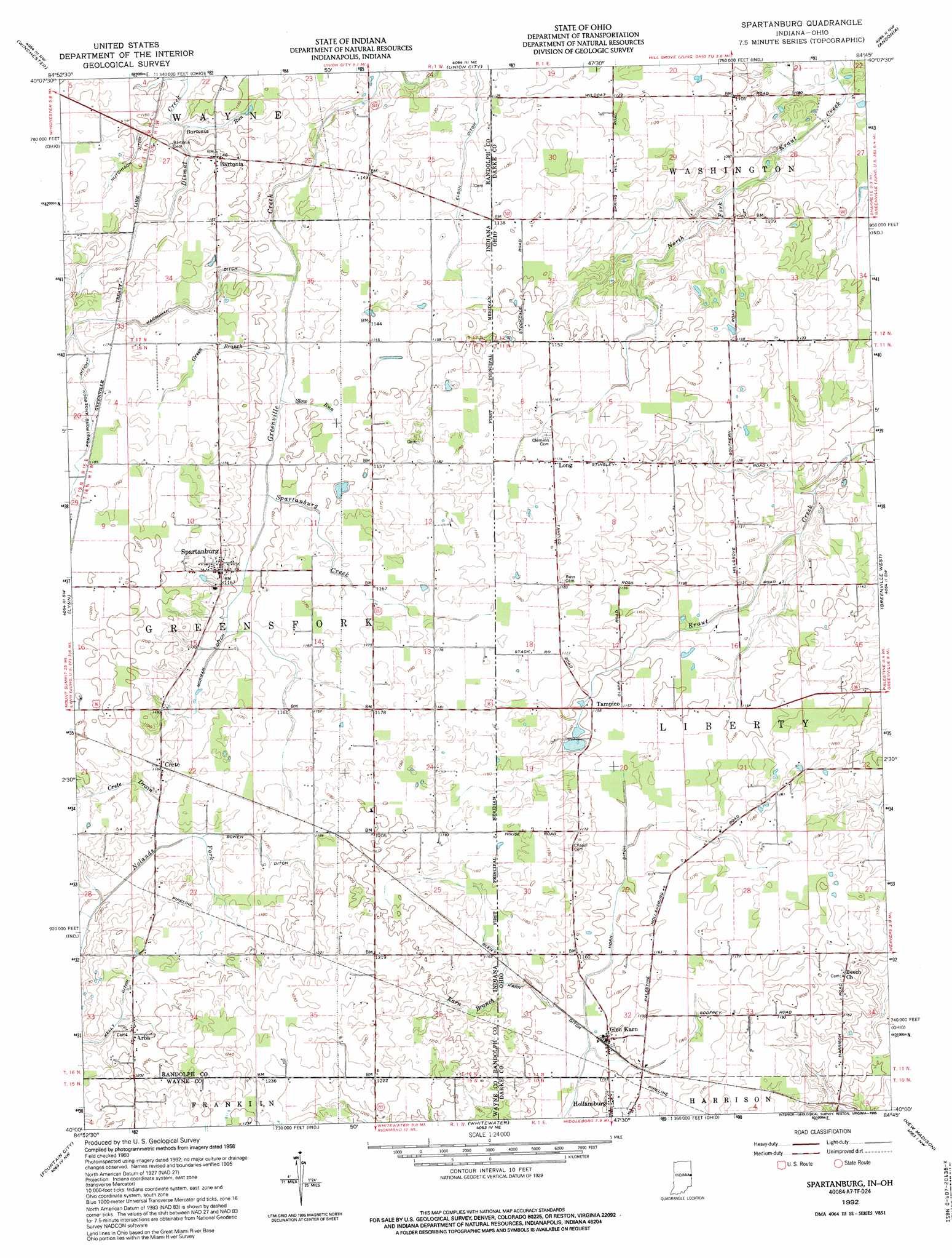
USGS Topo Quad 40084a7 - 1:24,000 scale
| Topo Map Name: | Spartanburg |
| USGS Topo Quad ID: | 40084a7 |
| Print Size: | ca. 21 1/4" wide x 27" high |
| Southeast Coordinates: | 40° N latitude / 84.75° W longitude |
| Map Center Coordinates: | 40.0625° N latitude / 84.8125° W longitude |
| U.S. States: | IN, OH |
| Filename: | o40084a7.jpg |
| Download Map JPG Image: | Spartanburg topo map 1:24,000 scale |
| Map Type: | Topographic |
| Topo Series: | 7.5´ |
| Map Scale: | 1:24,000 |
| Source of Map Images: | United States Geological Survey (USGS) |
| Alternate Map Versions: |
Spartanburg IN 1960, updated 1961 Download PDF Buy paper map Spartanburg IN 1960, updated 1973 Download PDF Buy paper map Spartanburg IN 1992, updated 1995 Download PDF Buy paper map Spartanburg IN 2010 Download PDF Buy paper map Spartanburg IN 2013 Download PDF Buy paper map Spartanburg IN 2016 Download PDF Buy paper map |
1:24,000 Topo Quads surrounding Spartanburg
Ridgeville |
Deerfield |
Cosmos |
Rossburg |
North Star |
Maxville |
Winchester |
Union City |
Ansonia |
Dawn |
Carlos |
Lynn |
Spartanburg |
Greenville West |
Greenville East |
Greens Fork |
Fountain City |
Whitewater |
New Madison |
Arcanum |
Jacksonburg |
Richmond |
New Paris |
Eaton North |
Lewisburg |
> Back to 40084a1 at 1:100,000 scale
> Back to 40084a1 at 1:250,000 scale
> Back to U.S. Topo Maps home
Spartanburg topo map: Gazetteer
Spartanburg: Canals
Armstrong Anderson Ditch elevation 359m 1177′Bowen Ditch elevation 355m 1164′
Elson Ditch elevation 343m 1125′
Glen Karn Ditch elevation 351m 1151′
Harshman Ditch elevation 352m 1154′
Horn Ditch elevation 350m 1148′
Hutchison Ditch elevation 348m 1141′
Morman Ditch elevation 352m 1154′
Spartanburg: Populated Places
Arba elevation 363m 1190′Bartonia elevation 351m 1151′
Crete elevation 362m 1187′
Glen Karn elevation 352m 1154′
Long elevation 357m 1171′
Spartanburg elevation 360m 1181′
Tampico elevation 351m 1151′
Spartanburg: Post Offices
Glenkarn Post Office (historical) elevation 352m 1154′Long Post Office (historical) elevation 357m 1171′
Tampico Post Office (historical) elevation 351m 1151′
Spartanburg: Streams
Bartonia Run elevation 344m 1128′Crete Drain elevation 350m 1148′
Green Branch elevation 344m 1128′
Karn Branch elevation 353m 1158′
Karn Branch elevation 353m 1158′
Slow Run elevation 347m 1138′
Spartanburg Creek elevation 347m 1138′
Spartanburg: Summits
Hoosier Hill elevation 381m 1250′Spartanburg digital topo map on disk
Buy this Spartanburg topo map showing relief, roads, GPS coordinates and other geographical features, as a high-resolution digital map file on DVD:
Northern Illinois, Northern Indiana & Southwestern Michigan
Buy digital topo maps: Northern Illinois, Northern Indiana & Southwestern Michigan