Versailles Topo Map Ohio
To zoom in, hover over the map of Versailles
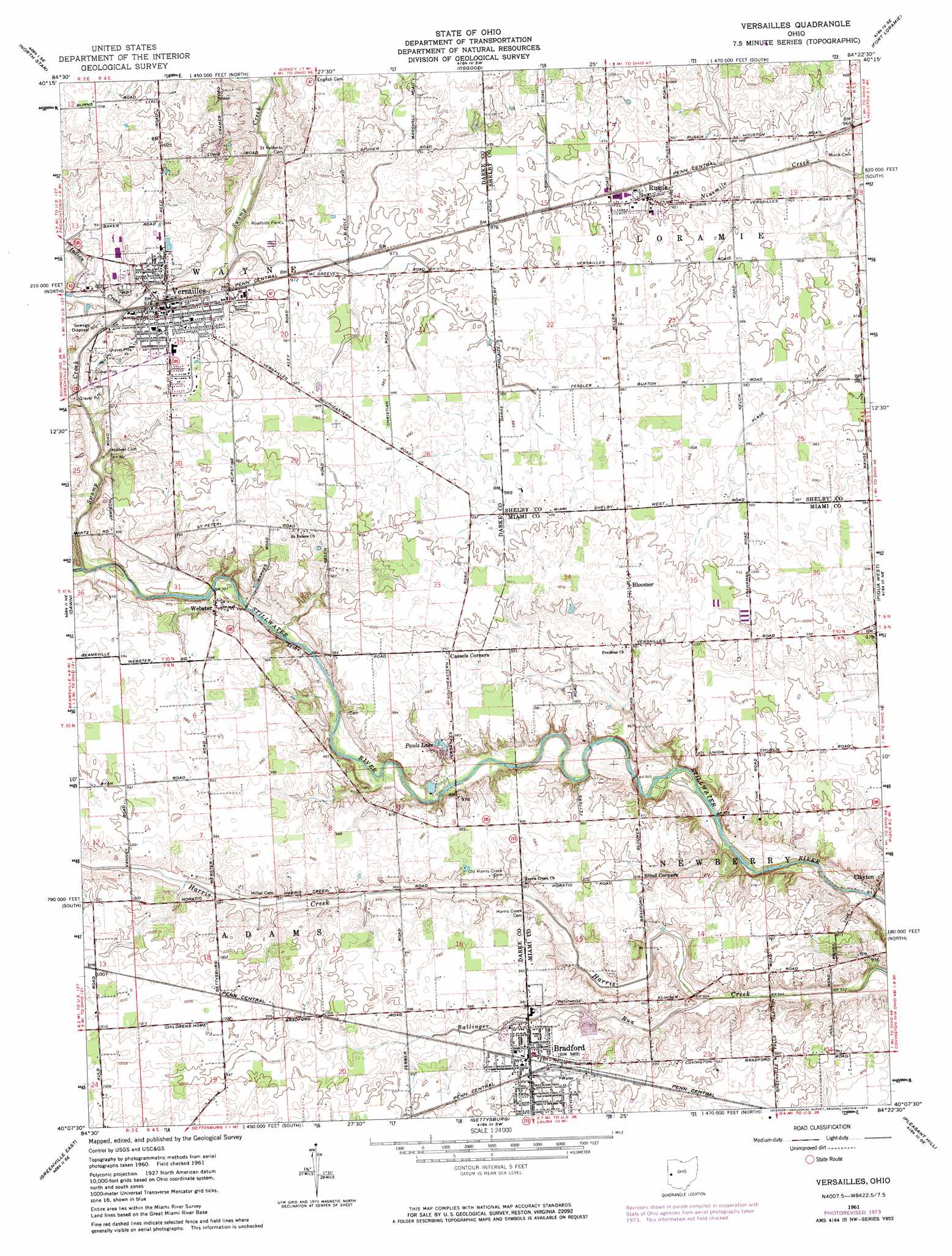
USGS Topo Quad 40084b4 - 1:24,000 scale
| Topo Map Name: | Versailles |
| USGS Topo Quad ID: | 40084b4 |
| Print Size: | ca. 21 1/4" wide x 27" high |
| Southeast Coordinates: | 40.125° N latitude / 84.375° W longitude |
| Map Center Coordinates: | 40.1875° N latitude / 84.4375° W longitude |
| U.S. State: | OH |
| Filename: | o40084b4.jpg |
| Download Map JPG Image: | Versailles topo map 1:24,000 scale |
| Map Type: | Topographic |
| Topo Series: | 7.5´ |
| Map Scale: | 1:24,000 |
| Source of Map Images: | United States Geological Survey (USGS) |
| Alternate Map Versions: |
Versailles OH 1961, updated 1962 Download PDF Buy paper map Versailles OH 1961, updated 1974 Download PDF Buy paper map Versailles OH 2010 Download PDF Buy paper map Versailles OH 2013 Download PDF Buy paper map Versailles OH 2016 Download PDF Buy paper map |
1:24,000 Topo Quads surrounding Versailles
Coldwater |
Montezuma |
New Bremen |
New Knoxville |
Botkins |
Rossburg |
North Star |
Osgood |
Fort Loramie |
Sidney |
Ansonia |
Dawn |
Versailles |
Piqua West |
Piqua East |
Greenville West |
Greenville East |
Gettysburg |
Pleasant Hill |
Troy |
New Madison |
Arcanum |
Laura |
West Milton |
Tipp City |
> Back to 40084a1 at 1:100,000 scale
> Back to 40084a1 at 1:250,000 scale
> Back to U.S. Topo Maps home
Versailles topo map: Gazetteer
Versailles: Canals
Klase Ditch elevation 294m 964′Versailles: Lakes
Pauls Lake elevation 295m 967′Versailles: Parks
Goode Prairie Preserve elevation 284m 931′Goode Prairie Reserve elevation 283m 928′
Indian Creek Park elevation 300m 984′
Poultry Days Park elevation 304m 997′
Stillwater Prairie Reserve elevation 296m 971′
Versailles: Populated Places
Bloomer elevation 311m 1020′Bradford elevation 301m 987′
Clayton elevation 283m 928′
North Jacksonville elevation 299m 980′
Russia elevation 295m 967′
Versailles elevation 300m 984′
Webster elevation 294m 964′
Versailles: Post Offices
Bloomer Post Office (historical) elevation 310m 1017′Bradford Post Office elevation 302m 990′
Russia Post Office elevation 295m 967′
Versailles Post Office elevation 300m 984′
Webster Post Office (historical) elevation 298m 977′
Versailles: Streams
Ballinger Run elevation 288m 944′Indian Creek elevation 291m 954′
Swamp Creek elevation 288m 944′
Versailles digital topo map on disk
Buy this Versailles topo map showing relief, roads, GPS coordinates and other geographical features, as a high-resolution digital map file on DVD:
Northern Illinois, Northern Indiana & Southwestern Michigan
Buy digital topo maps: Northern Illinois, Northern Indiana & Southwestern Michigan