Fort Loramie Topo Map Ohio
To zoom in, hover over the map of Fort Loramie
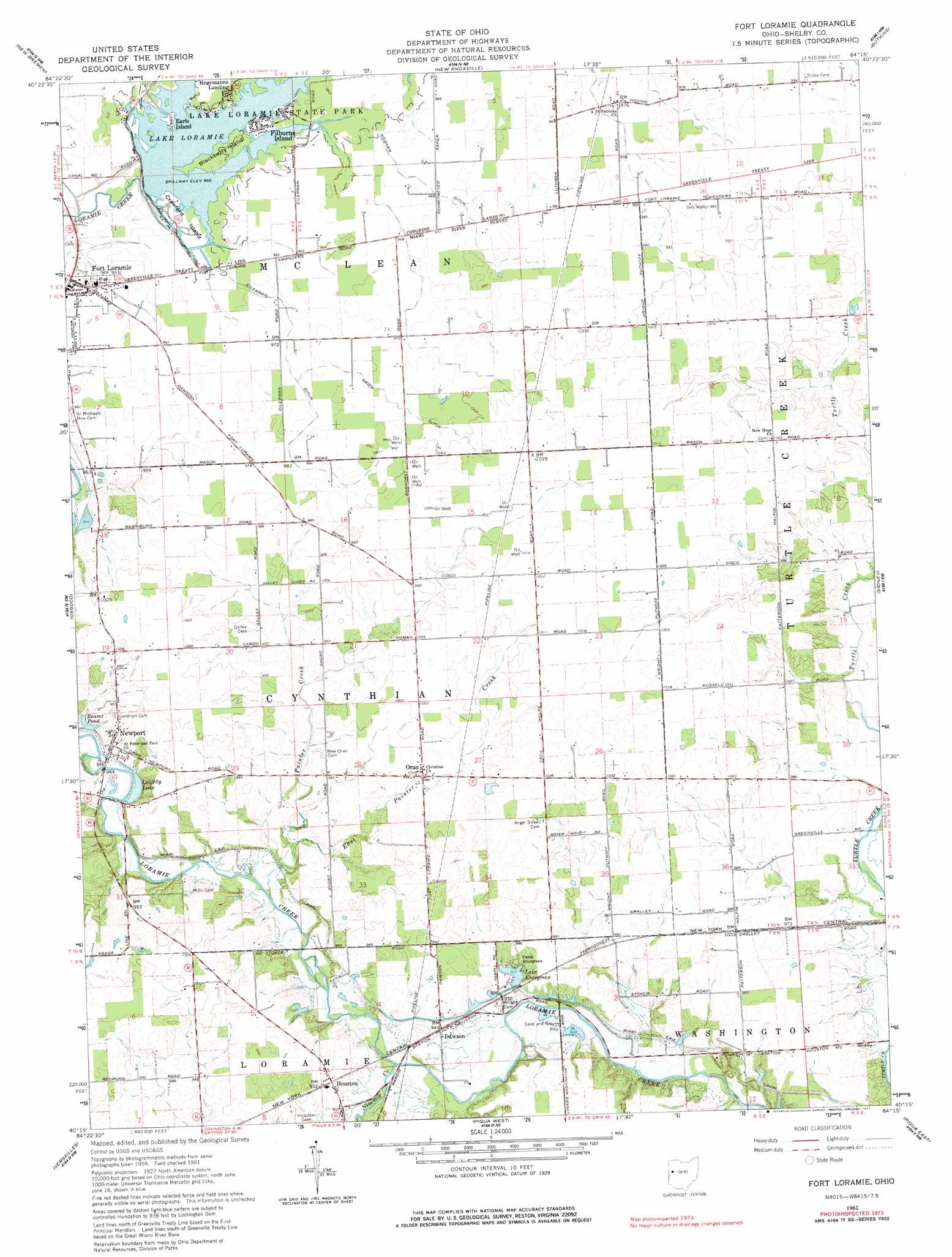
USGS Topo Quad 40084c3 - 1:24,000 scale
| Topo Map Name: | Fort Loramie |
| USGS Topo Quad ID: | 40084c3 |
| Print Size: | ca. 21 1/4" wide x 27" high |
| Southeast Coordinates: | 40.25° N latitude / 84.25° W longitude |
| Map Center Coordinates: | 40.3125° N latitude / 84.3125° W longitude |
| U.S. State: | OH |
| Filename: | o40084c3.jpg |
| Download Map JPG Image: | Fort Loramie topo map 1:24,000 scale |
| Map Type: | Topographic |
| Topo Series: | 7.5´ |
| Map Scale: | 1:24,000 |
| Source of Map Images: | United States Geological Survey (USGS) |
| Alternate Map Versions: |
Fort Loramie OH 1961, updated 1962 Download PDF Buy paper map Fort Loramie OH 1961, updated 1977 Download PDF Buy paper map Fort Loramie OH 2010 Download PDF Buy paper map Fort Loramie OH 2013 Download PDF Buy paper map Fort Loramie OH 2016 Download PDF Buy paper map |
1:24,000 Topo Quads surrounding Fort Loramie
Celina |
Saint Marys |
Moulton |
Wapakoneta |
Uniopolis |
Montezuma |
New Bremen |
New Knoxville |
Botkins |
Jackson Center |
North Star |
Osgood |
Fort Loramie |
Sidney |
Port Jefferson |
Dawn |
Versailles |
Piqua West |
Piqua East |
Fletcher |
Greenville East |
Gettysburg |
Pleasant Hill |
Troy |
Christiansburg |
> Back to 40084a1 at 1:100,000 scale
> Back to 40084a1 at 1:250,000 scale
> Back to U.S. Topo Maps home
Fort Loramie topo map: Gazetteer
Fort Loramie: Canals
Eilerman Ditch elevation 295m 967′Gaier Ditch elevation 299m 980′
Webner Ditch elevation 292m 958′
Fort Loramie: Dams
Lake Loramie Dam elevation 290m 951′Fort Loramie: Islands
Blackberry Island elevation 292m 958′Crawford Island elevation 289m 948′
Fort Loramie: Parks
Lake Loramie State Park elevation 292m 958′Fort Loramie: Populated Places
Dawson elevation 286m 938′Earls Island elevation 291m 954′
Filburns Island elevation 292m 958′
Fort Loramie elevation 289m 948′
Hegemanns Landing elevation 292m 958′
Houston elevation 292m 958′
Newport elevation 297m 974′
Oran elevation 300m 984′
Saint Patrick elevation 296m 971′
Uno elevation 308m 1010′
Fort Loramie: Post Offices
Dawson Post Office (historical) elevation 289m 948′Fort Loramie Post Office elevation 289m 948′
Houston Post Office elevation 292m 958′
Oran Post Office (historical) elevation 302m 990′
Saint Patricks Post Office (historical) elevation 296m 971′
Uno Post Office (historical) elevation 308m 1010′
Fort Loramie: Reservoirs
Lake Evergreen elevation 289m 948′Lake Loramie elevation 290m 951′
Leighty Lake elevation 294m 964′
Reams Pond elevation 290m 951′
Fort Loramie: Streams
East Painter Creek elevation 285m 935′Ninemile Creek elevation 277m 908′
Painter Creek elevation 280m 918′
Fort Loramie digital topo map on disk
Buy this Fort Loramie topo map showing relief, roads, GPS coordinates and other geographical features, as a high-resolution digital map file on DVD:
Northern Illinois, Northern Indiana & Southwestern Michigan
Buy digital topo maps: Northern Illinois, Northern Indiana & Southwestern Michigan