Osgood Topo Map Ohio
To zoom in, hover over the map of Osgood
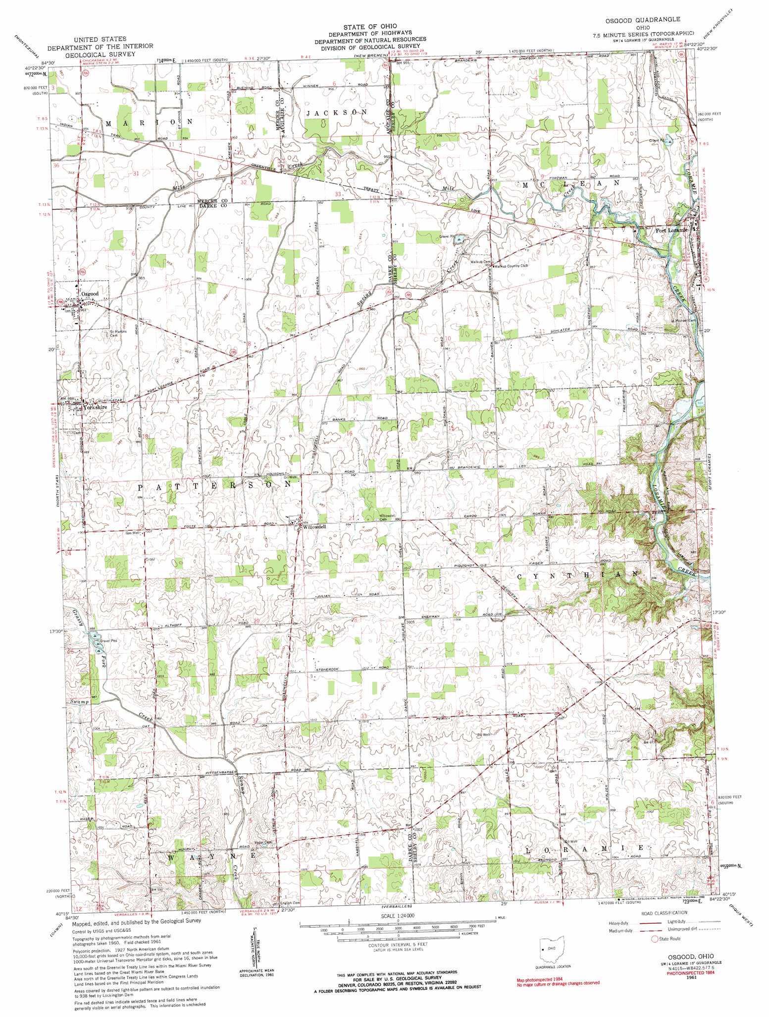
USGS Topo Quad 40084c4 - 1:24,000 scale
| Topo Map Name: | Osgood |
| USGS Topo Quad ID: | 40084c4 |
| Print Size: | ca. 21 1/4" wide x 27" high |
| Southeast Coordinates: | 40.25° N latitude / 84.375° W longitude |
| Map Center Coordinates: | 40.3125° N latitude / 84.4375° W longitude |
| U.S. State: | OH |
| Filename: | o40084c4.jpg |
| Download Map JPG Image: | Osgood topo map 1:24,000 scale |
| Map Type: | Topographic |
| Topo Series: | 7.5´ |
| Map Scale: | 1:24,000 |
| Source of Map Images: | United States Geological Survey (USGS) |
| Alternate Map Versions: |
Osgood OH 1961, updated 1963 Download PDF Buy paper map Osgood OH 1961, updated 1983 Download PDF Buy paper map Osgood OH 1961, updated 1990 Download PDF Buy paper map Osgood OH 2010 Download PDF Buy paper map Osgood OH 2013 Download PDF Buy paper map Osgood OH 2016 Download PDF Buy paper map |
1:24,000 Topo Quads surrounding Osgood
Erastus |
Celina |
Saint Marys |
Moulton |
Wapakoneta |
Coldwater |
Montezuma |
New Bremen |
New Knoxville |
Botkins |
Rossburg |
North Star |
Osgood |
Fort Loramie |
Sidney |
Ansonia |
Dawn |
Versailles |
Piqua West |
Piqua East |
Greenville West |
Greenville East |
Gettysburg |
Pleasant Hill |
Troy |
> Back to 40084a1 at 1:100,000 scale
> Back to 40084a1 at 1:250,000 scale
> Back to U.S. Topo Maps home
Osgood topo map: Gazetteer
Osgood: Dams
Barhorst Lake Dam elevation 288m 944′Osgood: Parks
Fort Loramie Park elevation 286m 938′Osgood: Populated Places
Osgood elevation 293m 961′Steinman (historical) elevation 291m 954′
Strakers (historical) elevation 306m 1003′
Willowdell elevation 303m 994′
Yorkshire elevation 299m 980′
Osgood: Post Offices
Osgood Post Office elevation 292m 958′Willowdell Post Office (historical) elevation 302m 990′
Yorkshire Post Office (historical) elevation 299m 980′
Osgood: Reservoirs
Barhorst Lake elevation 288m 944′Osgood: Streams
Grassy Fork elevation 297m 974′Lawrence Run elevation 283m 928′
Mile Creek elevation 286m 938′
Salt Lick elevation 283m 928′
Spring Creek elevation 285m 935′
Osgood digital topo map on disk
Buy this Osgood topo map showing relief, roads, GPS coordinates and other geographical features, as a high-resolution digital map file on DVD:
Northern Illinois, Northern Indiana & Southwestern Michigan
Buy digital topo maps: Northern Illinois, Northern Indiana & Southwestern Michigan