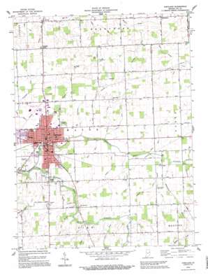
Portland Topo Map Indiana
To zoom in, hover over the map of Portland
USGS Topo Quad 40084d8 - 1:24,000 scale
| Topo Map Name: | Portland |
| USGS Topo Quad ID: | 40084d8 |
| Print Size: | ca. 21 1/4" wide x 27" high |
| Southeast Coordinates: | 40.375° N latitude / 84.875° W longitude |
| Map Center Coordinates: | 40.4375° N latitude / 84.9375° W longitude |
| U.S. State: | IN |
| Filename: | o40084d8.jpg |
| Download Map JPG Image: | Portland topo map 1:24,000 scale |
| Map Type: | Topographic |
| Topo Series: | 7.5´ |
| Map Scale: | 1:24,000 |
| Source of Map Images: | United States Geological Survey (USGS) |
| Alternate Map Versions: |
Portland IN 1960, updated 1961 Download PDF Buy paper map Portland IN 1960, updated 1988 Download PDF Buy paper map Portland IN 1992, updated 1995 Download PDF Buy paper map Portland IN 2010 Download PDF Buy paper map Portland IN 2013 Download PDF Buy paper map Portland IN 2016 Download PDF Buy paper map |
1:24,000 Topo Quads surrounding Portland
> Back to 40084a1 at 1:100,000 scale
> Back to 40084a1 at 1:250,000 scale
> Back to U.S. Topo Maps home
Portland topo map: Gazetteer
Portland: Airports
Steed Field elevation 278m 912′Portland: Canals
Alexander Ditch elevation 280m 918′Antiville Ditch elevation 273m 895′
Ashley Ditch elevation 287m 941′
Berger Ditch elevation 282m 925′
Bockoven Ditch elevation 269m 882′
Burkey Ditch elevation 280m 918′
Freemyer Ditch elevation 273m 895′
Hodge Ditch elevation 281m 921′
Houte Ditch elevation 282m 925′
Karnes Ditch elevation 272m 892′
McKinsey Ditch elevation 281m 921′
Scholer Ditch elevation 284m 931′
Young Ditch elevation 280m 918′
Portland: Parks
Haynes Park elevation 276m 905′John Cring Memorial Forest elevation 288m 944′
Portland: Populated Places
Antiville elevation 272m 892′Brice elevation 281m 921′
College Corner elevation 281m 921′
Liber elevation 284m 931′
Pleasant Ridge elevation 284m 931′
Portland elevation 276m 905′
Westchester elevation 275m 902′
Portland: Streams
Buckeye Creek elevation 280m 918′Golf Brook elevation 274m 898′
Little Salamonie River elevation 273m 895′
Millers Branch elevation 277m 908′
Old Run elevation 285m 935′
Race Run elevation 275m 902′
Rest Run elevation 281m 921′
Sale Run elevation 283m 928′
Saw Run elevation 278m 912′
Sycamore Fork elevation 280m 918′
Walnut Creek elevation 287m 941′
Portland digital topo map on disk
Buy this Portland topo map showing relief, roads, GPS coordinates and other geographical features, as a high-resolution digital map file on DVD:
Northern Illinois, Northern Indiana & Southwestern Michigan
Buy digital topo maps: Northern Illinois, Northern Indiana & Southwestern Michigan


