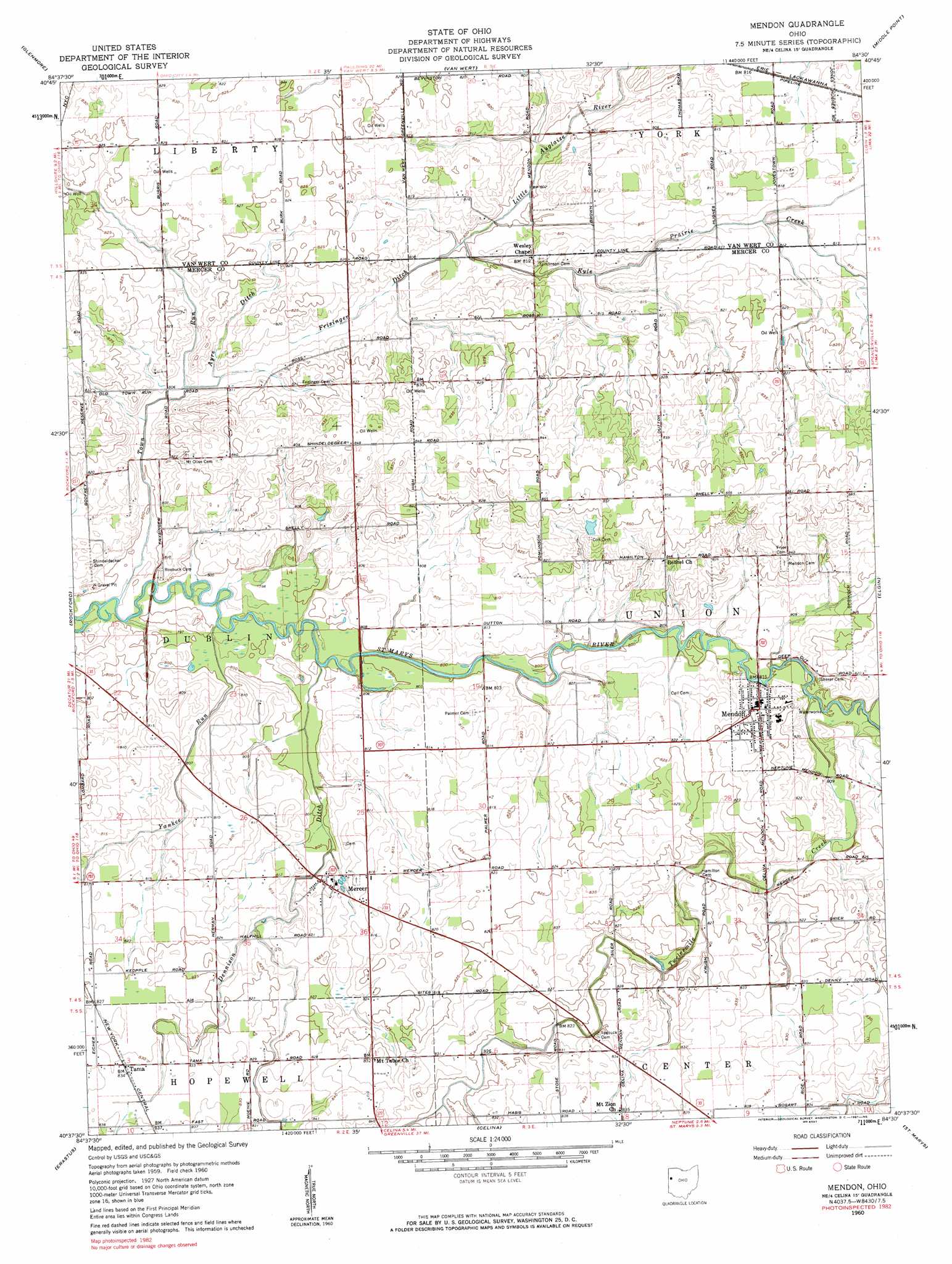
Mendon Topo Map Ohio
To zoom in, hover over the map of Mendon
USGS Topo Quad 40084f5 - 1:24,000 scale
| Topo Map Name: | Mendon |
| USGS Topo Quad ID: | 40084f5 |
| Print Size: | ca. 21 1/4" wide x 27" high |
| Southeast Coordinates: | 40.625° N latitude / 84.5° W longitude |
| Map Center Coordinates: | 40.6875° N latitude / 84.5625° W longitude |
| U.S. State: | OH |
| Filename: | o40084f5.jpg |
| Download Map JPG Image: | Mendon topo map 1:24,000 scale |
| Map Type: | Topographic |
| Topo Series: | 7.5´ |
| Map Scale: | 1:24,000 |
| Source of Map Images: | United States Geological Survey (USGS) |
| Alternate Map Versions: |
Mendon OH 1960, updated 1961 Download PDF Buy paper map Mendon OH 1960, updated 1982 Download PDF Buy paper map Mendon OH 2010 Download PDF Buy paper map Mendon OH 2013 Download PDF Buy paper map Mendon OH 2016 Download PDF Buy paper map |
1:24,000 Topo Quads surrounding Mendon
Dixon |
Convoy |
Scott |
Wetsel |
Ottoville |
Wren |
Glenmore |
Van Wert |
Middle Point |
Delphos |
Willshire |
Rockford |
Mendon |
Elgin |
Spencerville |
New Corydon |
Erastus |
Celina |
Saint Marys |
Moulton |
Fort Recovery |
Coldwater |
Montezuma |
New Bremen |
New Knoxville |
> Back to 40084e1 at 1:100,000 scale
> Back to 40084a1 at 1:250,000 scale
> Back to U.S. Topo Maps home
Mendon topo map: Gazetteer
Mendon: Populated Places
Mendon elevation 250m 820′Mercer elevation 246m 807′
Tama elevation 253m 830′
Mendon: Post Offices
Mendon Post Office elevation 250m 820′Mercer Post Office (historical) elevation 246m 807′
Tamah Post Office (historical) elevation 253m 830′
Mendon: Streams
Ayre Ditch elevation 245m 803′Dennison Ditch elevation 242m 793′
Frisinger Ditch elevation 242m 793′
Kyle Prairie Creek elevation 242m 793′
Town Run elevation 242m 793′
Twelvemile Creek elevation 244m 800′
Yankee Run elevation 242m 793′
Mendon digital topo map on disk
Buy this Mendon topo map showing relief, roads, GPS coordinates and other geographical features, as a high-resolution digital map file on DVD:
Northern Illinois, Northern Indiana & Southwestern Michigan
Buy digital topo maps: Northern Illinois, Northern Indiana & Southwestern Michigan