Berne Topo Map Indiana
To zoom in, hover over the map of Berne
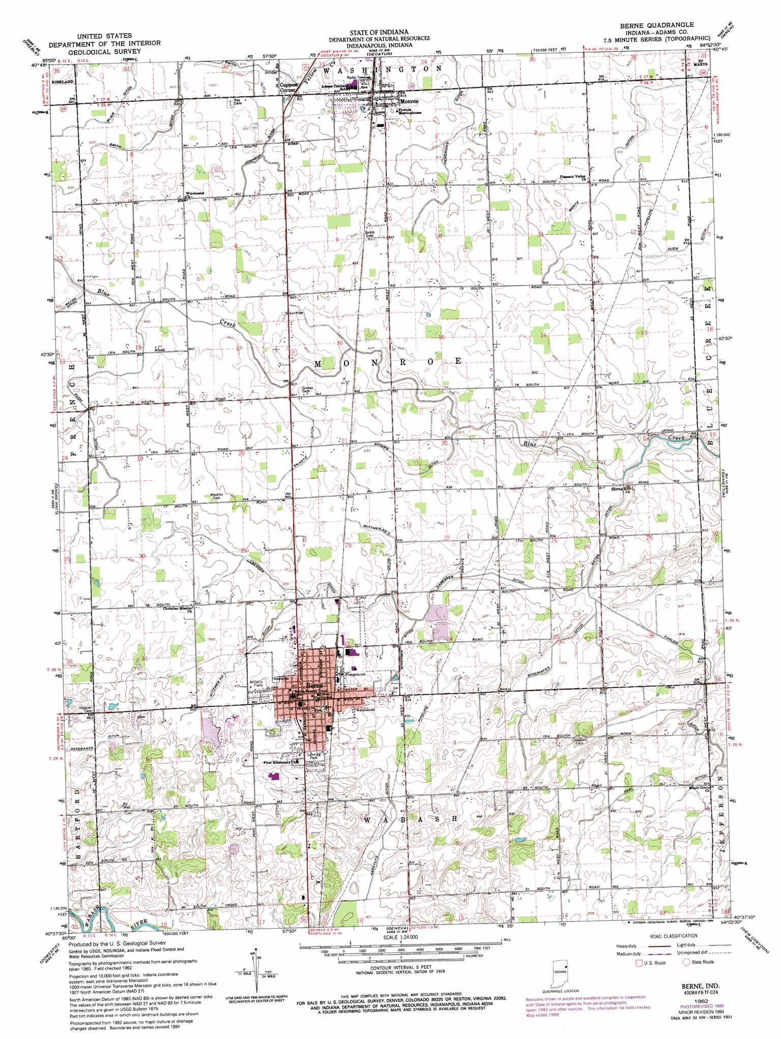
USGS Topo Quad 40084f8 - 1:24,000 scale
| Topo Map Name: | Berne |
| USGS Topo Quad ID: | 40084f8 |
| Print Size: | ca. 21 1/4" wide x 27" high |
| Southeast Coordinates: | 40.625° N latitude / 84.875° W longitude |
| Map Center Coordinates: | 40.6875° N latitude / 84.9375° W longitude |
| U.S. State: | IN |
| Filename: | o40084f8.jpg |
| Download Map JPG Image: | Berne topo map 1:24,000 scale |
| Map Type: | Topographic |
| Topo Series: | 7.5´ |
| Map Scale: | 1:24,000 |
| Source of Map Images: | United States Geological Survey (USGS) |
| Alternate Map Versions: |
Berne IN 1962, updated 1964 Download PDF Buy paper map Berne IN 1962, updated 1988 Download PDF Buy paper map Berne IN 1962, updated 1994 Download PDF Buy paper map Berne IN 2010 Download PDF Buy paper map Berne IN 2013 Download PDF Buy paper map Berne IN 2016 Download PDF Buy paper map |
1:24,000 Topo Quads surrounding Berne
Ossian |
Poe |
Hoagland |
Dixon |
Convoy |
Uniondale |
Preble |
Decatur |
Wren |
Glenmore |
Bluffton |
Linn Grove |
Berne |
Willshire |
Rockford |
Petroleum |
Domestic |
Geneva |
New Corydon |
Erastus |
Pennville |
Blaine |
Portland |
Fort Recovery |
Coldwater |
> Back to 40084e1 at 1:100,000 scale
> Back to 40084a1 at 1:250,000 scale
> Back to U.S. Topo Maps home
Berne topo map: Gazetteer
Berne: Airports
Sprungers South Adams County Airstrip elevation 258m 846′Berne: Canals
Duer Ditch elevation 249m 816′Farlow Ditch elevation 251m 823′
Fuch Ditch elevation 259m 849′
Gates Ditch elevation 249m 816′
Habegger Ditch elevation 252m 826′
Hendericks Ditch elevation 249m 816′
Jamstutz Ditch elevation 251m 823′
Johnson Ditch elevation 252m 826′
Martz Ditch elevation 249m 816′
Peel Ditch elevation 257m 843′
Schugg Ditch elevation 254m 833′
Smith Ditch elevation 252m 826′
Smith Shoemaker Ditch elevation 248m 813′
Sprunger Ditch elevation 252m 826′
Swartz Ditch elevation 256m 839′
Wittmer Number One Ditch elevation 259m 849′
Wittmer Number Two Ditch elevation 254m 833′
Berne: Parks
Four-H Park elevation 251m 823′Lehman Park elevation 262m 859′
Berne: Populated Places
Berne elevation 258m 846′Coppess Corner elevation 251m 823′
Monroe elevation 251m 823′
Berne digital topo map on disk
Buy this Berne topo map showing relief, roads, GPS coordinates and other geographical features, as a high-resolution digital map file on DVD:
Northern Illinois, Northern Indiana & Southwestern Michigan
Buy digital topo maps: Northern Illinois, Northern Indiana & Southwestern Michigan