Scott Topo Map Ohio
To zoom in, hover over the map of Scott
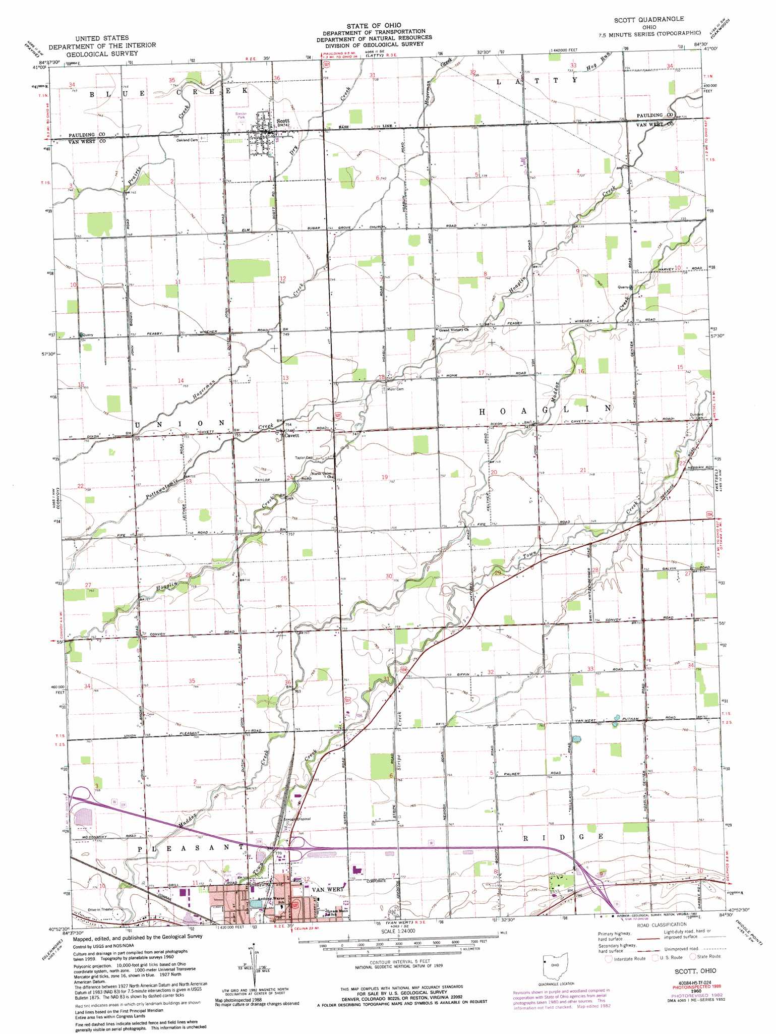
USGS Topo Quad 40084h5 - 1:24,000 scale
| Topo Map Name: | Scott |
| USGS Topo Quad ID: | 40084h5 |
| Print Size: | ca. 21 1/4" wide x 27" high |
| Southeast Coordinates: | 40.875° N latitude / 84.5° W longitude |
| Map Center Coordinates: | 40.9375° N latitude / 84.5625° W longitude |
| U.S. State: | OH |
| Filename: | o40084h5.jpg |
| Download Map JPG Image: | Scott topo map 1:24,000 scale |
| Map Type: | Topographic |
| Topo Series: | 7.5´ |
| Map Scale: | 1:24,000 |
| Source of Map Images: | United States Geological Survey (USGS) |
| Alternate Map Versions: |
Scott OH 1960, updated 1961 Download PDF Buy paper map Scott OH 1960, updated 1972 Download PDF Buy paper map Scott OH 1960, updated 1983 Download PDF Buy paper map Scott OH 1960, updated 1992 Download PDF Buy paper map Scott OH 2010 Download PDF Buy paper map Scott OH 2013 Download PDF Buy paper map Scott OH 2016 Download PDF Buy paper map |
1:24,000 Topo Quads surrounding Scott
Woodburn North |
Antwerp |
Paulding |
Junction |
Ayersville |
Woodburn South |
Payne |
Latty |
Oakwood |
Continental |
Dixon |
Convoy |
Scott |
Wetsel |
Ottoville |
Wren |
Glenmore |
Van Wert |
Middle Point |
Delphos |
Willshire |
Rockford |
Mendon |
Elgin |
Spencerville |
> Back to 40084e1 at 1:100,000 scale
> Back to 40084a1 at 1:250,000 scale
> Back to U.S. Topo Maps home
Scott topo map: Gazetteer
Scott: Canals
Wilmore Ditch elevation 231m 757′Scott: Parks
Bresler Park elevation 225m 738′Jubilee Park elevation 235m 770′
Wesley Park elevation 236m 774′
Scott: Populated Places
Cavett elevation 230m 754′Scott elevation 224m 734′
Scott: Post Offices
Cavett Post Office (historical) elevation 230m 754′Scott: Streams
Pottawatomie Creek elevation 227m 744′Stripe Creek elevation 229m 751′
Scott digital topo map on disk
Buy this Scott topo map showing relief, roads, GPS coordinates and other geographical features, as a high-resolution digital map file on DVD:
Northern Illinois, Northern Indiana & Southwestern Michigan
Buy digital topo maps: Northern Illinois, Northern Indiana & Southwestern Michigan