Muncie East Topo Map Indiana
To zoom in, hover over the map of Muncie East
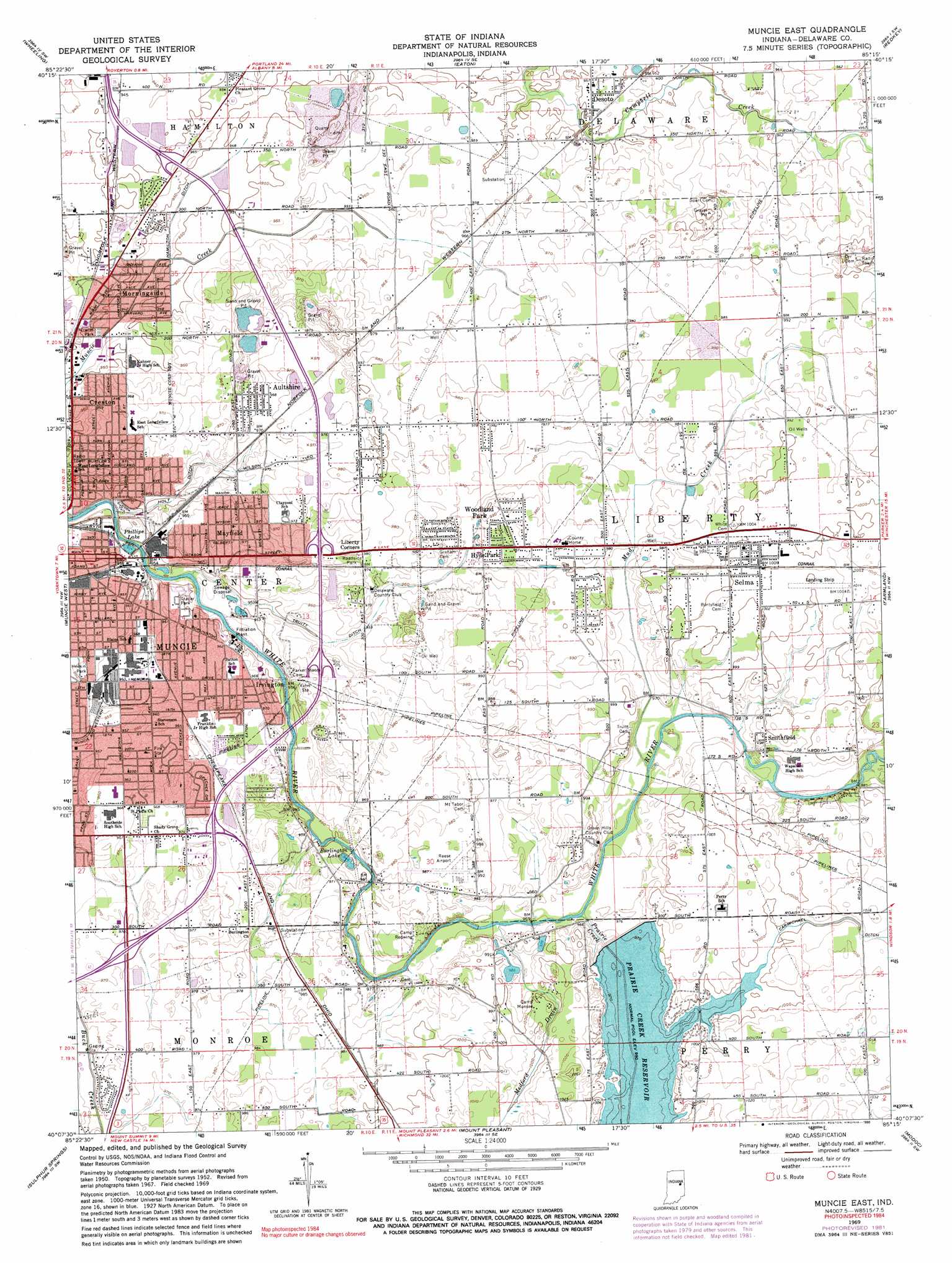
USGS Topo Quad 40085b3 - 1:24,000 scale
| Topo Map Name: | Muncie East |
| USGS Topo Quad ID: | 40085b3 |
| Print Size: | ca. 21 1/4" wide x 27" high |
| Southeast Coordinates: | 40.125° N latitude / 85.25° W longitude |
| Map Center Coordinates: | 40.1875° N latitude / 85.3125° W longitude |
| U.S. State: | IN |
| Filename: | o40085b3.jpg |
| Download Map JPG Image: | Muncie East topo map 1:24,000 scale |
| Map Type: | Topographic |
| Topo Series: | 7.5´ |
| Map Scale: | 1:24,000 |
| Source of Map Images: | United States Geological Survey (USGS) |
| Alternate Map Versions: |
Muncie East IN 1952, updated 1953 Download PDF Buy paper map Muncie East IN 1962, updated 1964 Download PDF Buy paper map Muncie East IN 1969, updated 1971 Download PDF Buy paper map Muncie East IN 1969, updated 1982 Download PDF Buy paper map Muncie East IN 1969, updated 1990 Download PDF Buy paper map Muncie East IN 2010 Download PDF Buy paper map Muncie East IN 2013 Download PDF Buy paper map Muncie East IN 2016 Download PDF Buy paper map |
1:24,000 Topo Quads surrounding Muncie East
Gas City |
Hartford City West |
Hartford City East |
Pennville |
Blaine |
Gaston |
Wheeling |
Eaton |
Redkey |
Ridgeville |
Gilman |
Muncie West |
Muncie East |
Farmland |
Maxville |
Middletown |
Sulphur Springs |
Mount Pleasant |
Modoc |
Carlos |
Shirley |
New Castle West |
New Castle East |
Hagerstown |
Greens Fork |
> Back to 40085a1 at 1:100,000 scale
> Back to 40084a1 at 1:250,000 scale
> Back to U.S. Topo Maps home
Muncie East topo map: Gazetteer
Muncie East: Airports
Reese Airport elevation 301m 987′Selma Airport elevation 305m 1000′
Muncie East: Canals
Carmichael Ditch elevation 307m 1007′Holt Ditch elevation 291m 954′
Muncie East: Dams
Prairie Creek Reservoir Dam elevation 303m 994′Muncie East: Lakes
Burlington Lake elevation 289m 948′Phillips Lake elevation 287m 941′
Muncie East: Parks
Camp Munsee elevation 302m 990′Camp Redwing elevation 296m 971′
McCullouch Park elevation 294m 964′
Riverview Park elevation 287m 941′
Muncie East: Populated Places
Aultshire elevation 297m 974′Creston elevation 291m 954′
Desoto elevation 292m 958′
Hyde Park elevation 300m 984′
Irvington elevation 296m 971′
Liberty Corners elevation 299m 980′
Mayfield elevation 293m 961′
Morningside elevation 289m 948′
Selma elevation 306m 1003′
Smithfield elevation 300m 984′
Woodland Park elevation 300m 984′
Muncie East: Reservoirs
Prairie Creek Reservoir elevation 304m 997′Muncie East: Streams
Hamilton Ditch elevation 289m 948′Medford Drain elevation 291m 954′
Mud Creek elevation 294m 964′
Prairie Creek elevation 291m 954′
Truitt Ditch elevation 286m 938′
Muncie East digital topo map on disk
Buy this Muncie East topo map showing relief, roads, GPS coordinates and other geographical features, as a high-resolution digital map file on DVD:
Northern Illinois, Northern Indiana & Southwestern Michigan
Buy digital topo maps: Northern Illinois, Northern Indiana & Southwestern Michigan