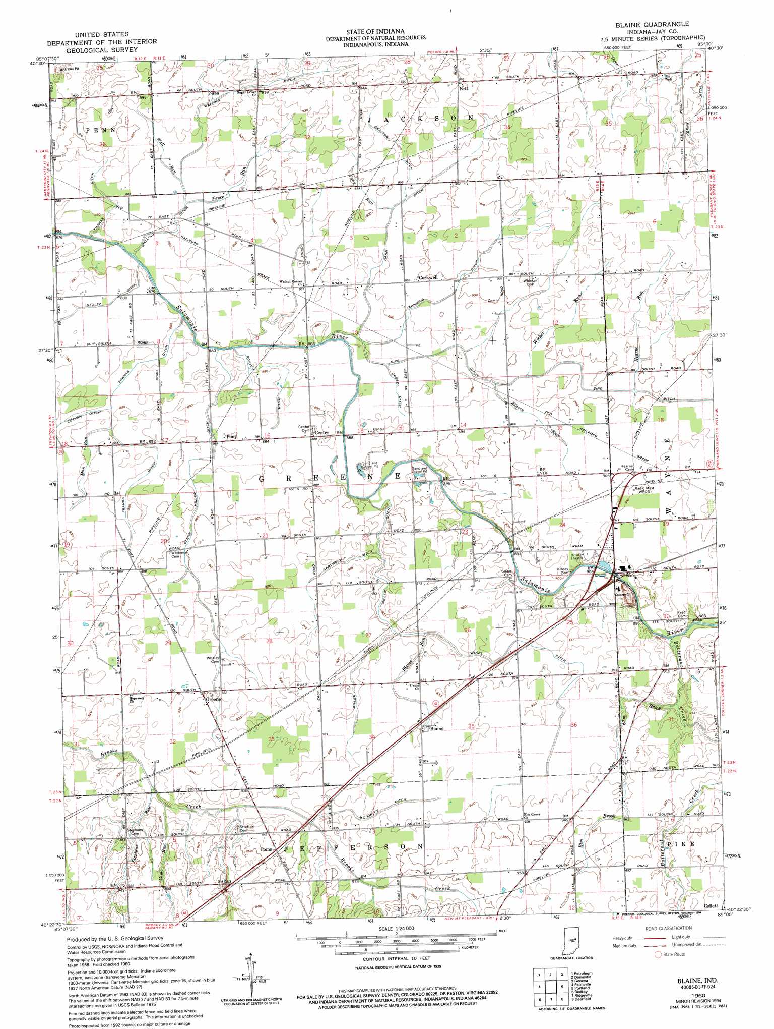
Blaine Topo Map Indiana
To zoom in, hover over the map of Blaine
USGS Topo Quad 40085d1 - 1:24,000 scale
| Topo Map Name: | Blaine |
| USGS Topo Quad ID: | 40085d1 |
| Print Size: | ca. 21 1/4" wide x 27" high |
| Southeast Coordinates: | 40.375° N latitude / 85° W longitude |
| Map Center Coordinates: | 40.4375° N latitude / 85.0625° W longitude |
| U.S. State: | IN |
| Filename: | o40085d1.jpg |
| Download Map JPG Image: | Blaine topo map 1:24,000 scale |
| Map Type: | Topographic |
| Topo Series: | 7.5´ |
| Map Scale: | 1:24,000 |
| Source of Map Images: | United States Geological Survey (USGS) |
| Alternate Map Versions: |
Blaine IN 1960, updated 1961 Download PDF Buy paper map Blaine IN 1960, updated 1961 Download PDF Buy paper map Blaine IN 1960, updated 1994 Download PDF Buy paper map Blaine IN 2010 Download PDF Buy paper map Blaine IN 2013 Download PDF Buy paper map Blaine IN 2016 Download PDF Buy paper map |
1:24,000 Topo Quads surrounding Blaine
Liberty Center |
Bluffton |
Linn Grove |
Berne |
Willshire |
Montpelier |
Petroleum |
Domestic |
Geneva |
New Corydon |
Hartford City East |
Pennville |
Blaine |
Portland |
Fort Recovery |
Eaton |
Redkey |
Ridgeville |
Deerfield |
Cosmos |
Muncie East |
Farmland |
Maxville |
Winchester |
Union City |
> Back to 40085a1 at 1:100,000 scale
> Back to 40084a1 at 1:250,000 scale
> Back to U.S. Topo Maps home
Blaine topo map: Gazetteer
Blaine: Canals
Bealton Ditch elevation 275m 902′Cartwright Ditch elevation 275m 902′
Cassell Ditch elevation 269m 882′
Dority Ditch elevation 267m 875′
Franks Ditch elevation 270m 885′
Glenn Miller Ditch elevation 273m 895′
Hahn Ditch elevation 270m 885′
Lanning Ditch elevation 273m 895′
May Ditch elevation 276m 905′
McKinley Ditch elevation 284m 931′
Miller Ditch elevation 279m 915′
Myran Ditch elevation 269m 882′
Priest Ditch elevation 276m 905′
Sipe Ditch elevation 270m 885′
Stultz Ditch elevation 268m 879′
Thomas Ditch elevation 269m 882′
Walling Ditch elevation 273m 895′
Wikel Ditch elevation 280m 918′
Blaine: Populated Places
Blaine elevation 283m 928′Center elevation 270m 885′
Collett elevation 293m 961′
Como elevation 288m 944′
Corkwell elevation 271m 889′
Greene elevation 281m 921′
Kitt elevation 283m 928′
Pony elevation 269m 882′
Blaine: Streams
Blaine Run elevation 276m 905′Butternut Creek elevation 282m 925′
Como Run elevation 279m 915′
Elm Brook elevation 282m 925′
Fence Run elevation 268m 879′
Hearne Run elevation 273m 895′
Kinsey Run elevation 270m 885′
Man Run elevation 268m 879′
New Mount Run elevation 285m 935′
Pony Run elevation 271m 889′
Stephens Run elevation 279m 915′
Wall Run elevation 269m 882′
Wicker Run elevation 271m 889′
Blaine digital topo map on disk
Buy this Blaine topo map showing relief, roads, GPS coordinates and other geographical features, as a high-resolution digital map file on DVD:
Northern Illinois, Northern Indiana & Southwestern Michigan
Buy digital topo maps: Northern Illinois, Northern Indiana & Southwestern Michigan