Domestic Topo Map Indiana
To zoom in, hover over the map of Domestic
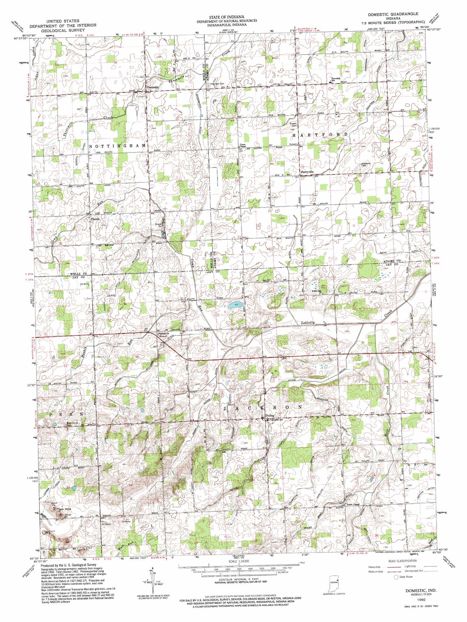
USGS Topo Quad 40085e1 - 1:24,000 scale
| Topo Map Name: | Domestic |
| USGS Topo Quad ID: | 40085e1 |
| Print Size: | ca. 21 1/4" wide x 27" high |
| Southeast Coordinates: | 40.5° N latitude / 85° W longitude |
| Map Center Coordinates: | 40.5625° N latitude / 85.0625° W longitude |
| U.S. State: | IN |
| Filename: | o40085e1.jpg |
| Download Map JPG Image: | Domestic topo map 1:24,000 scale |
| Map Type: | Topographic |
| Topo Series: | 7.5´ |
| Map Scale: | 1:24,000 |
| Source of Map Images: | United States Geological Survey (USGS) |
| Alternate Map Versions: |
Domestic IN 1962, updated 1964 Download PDF Buy paper map Domestic IN 1992, updated 1995 Download PDF Buy paper map Domestic IN 2010 Download PDF Buy paper map Domestic IN 2013 Download PDF Buy paper map Domestic IN 2016 Download PDF Buy paper map |
1:24,000 Topo Quads surrounding Domestic
Markle |
Uniondale |
Preble |
Decatur |
Wren |
Liberty Center |
Bluffton |
Linn Grove |
Berne |
Willshire |
Montpelier |
Petroleum |
Domestic |
Geneva |
New Corydon |
Hartford City East |
Pennville |
Blaine |
Portland |
Fort Recovery |
Eaton |
Redkey |
Ridgeville |
Deerfield |
Cosmos |
> Back to 40085e1 at 1:100,000 scale
> Back to 40084a1 at 1:250,000 scale
> Back to U.S. Topo Maps home
Domestic topo map: Gazetteer
Domestic: Canals
Anderson Ditch elevation 253m 830′Bourne Williams Ditch elevation 262m 859′
Crampton Ditch elevation 269m 882′
Downing Ditch elevation 259m 849′
Egley Ditch elevation 256m 839′
Glendenning Ditch elevation 258m 846′
Hunt Ditch elevation 261m 856′
McAllister Ditch elevation 261m 856′
Myers West Ditch elevation 268m 879′
Powell Ditch elevation 267m 875′
Rankin Lewis Ditch elevation 264m 866′
Roth Ditch elevation 256m 839′
Rupel Ditch elevation 256m 839′
Schott Ditch elevation 262m 859′
Shirk Votaw Ditch elevation 257m 843′
Shoemaker Ditch elevation 255m 836′
Thomas Ditch elevation 271m 889′
Vandorn Ditch elevation 261m 856′
Votaw Ditch elevation 260m 853′
Weaver Ditch elevation 269m 882′
Domestic: Populated Places
Domestic elevation 263m 862′Perryville elevation 260m 853′
Phenix elevation 266m 872′
Poling elevation 264m 866′
Domestic: Reservoirs
Loew Lake elevation 269m 882′Domestic: Streams
Camp Run elevation 255m 836′Haskin Run elevation 256m 839′
Wolf Creek elevation 254m 833′
Domestic: Summits
Twin Hills elevation 287m 941′Domestic digital topo map on disk
Buy this Domestic topo map showing relief, roads, GPS coordinates and other geographical features, as a high-resolution digital map file on DVD:
Northern Illinois, Northern Indiana & Southwestern Michigan
Buy digital topo maps: Northern Illinois, Northern Indiana & Southwestern Michigan