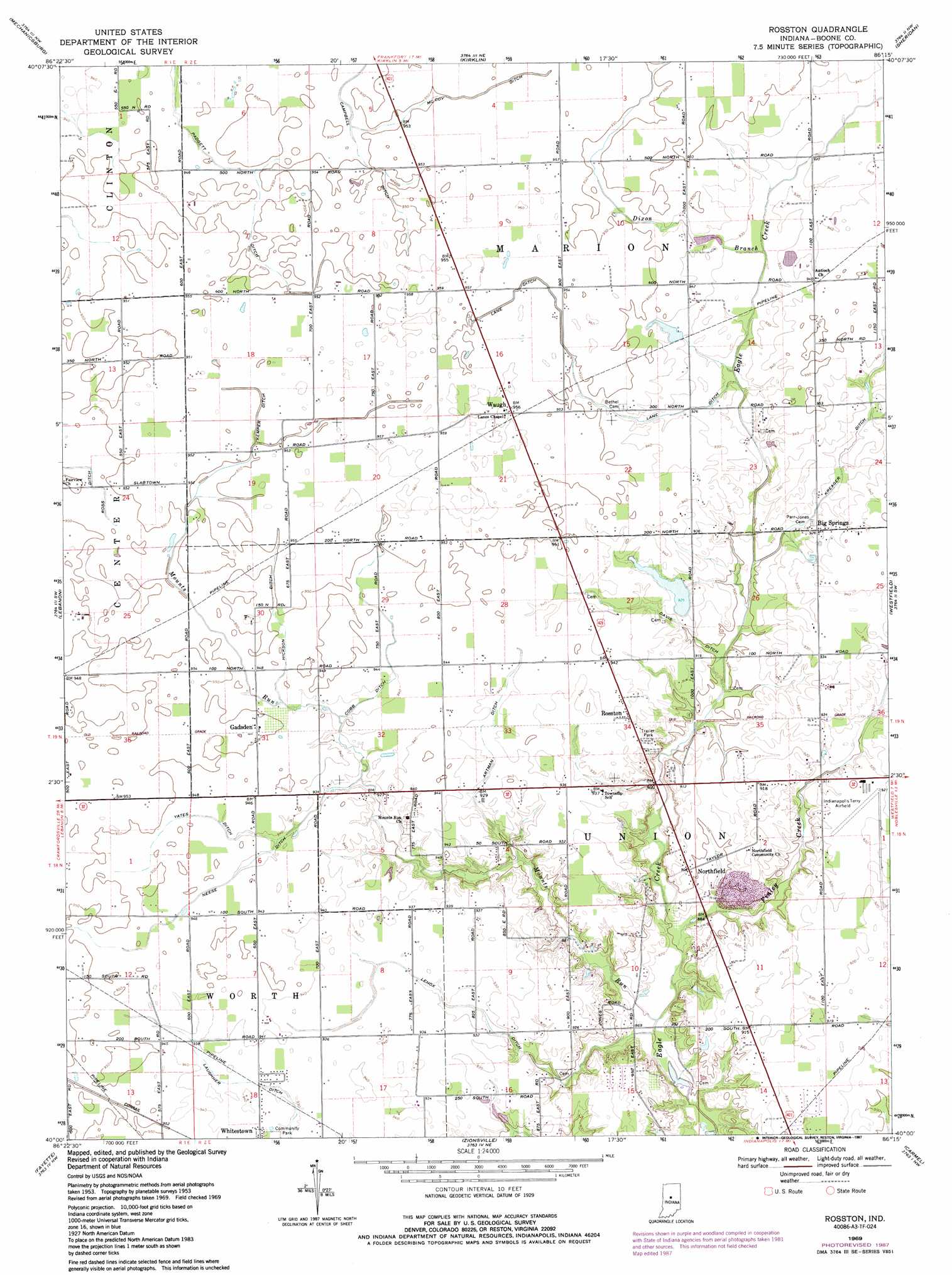
Rosston Topo Map Indiana
To zoom in, hover over the map of Rosston
USGS Topo Quad 40086a3 - 1:24,000 scale
| Topo Map Name: | Rosston |
| USGS Topo Quad ID: | 40086a3 |
| Print Size: | ca. 21 1/4" wide x 27" high |
| Southeast Coordinates: | 40° N latitude / 86.25° W longitude |
| Map Center Coordinates: | 40.0625° N latitude / 86.3125° W longitude |
| U.S. State: | IN |
| Filename: | o40086a3.jpg |
| Download Map JPG Image: | Rosston topo map 1:24,000 scale |
| Map Type: | Topographic |
| Topo Series: | 7.5´ |
| Map Scale: | 1:24,000 |
| Source of Map Images: | United States Geological Survey (USGS) |
| Alternate Map Versions: |
Rosston IN 1953, updated 1954 Download PDF Buy paper map Rosston IN 1969, updated 1972 Download PDF Buy paper map Rosston IN 1969, updated 1987 Download PDF Buy paper map Rosston IN 2010 Download PDF Buy paper map Rosston IN 2013 Download PDF Buy paper map Rosston IN 2016 Download PDF Buy paper map |
1:24,000 Topo Quads surrounding Rosston
Frankfort |
Michigantown |
Hillisburg |
Kempton |
Tipton |
Thorntown |
Mechanicsburg |
Kirklin |
Sheridan |
Arcadia |
Hazelrigg |
Lebanon |
Rosston |
Westfield |
Noblesville |
Lizton |
Fayette |
Zionsville |
Carmel |
Fishers |
Danville |
Brownsburg |
Clermont |
Indianapolis West |
Indianapolis East |
> Back to 40086a1 at 1:100,000 scale
> Back to 40086a1 at 1:250,000 scale
> Back to U.S. Topo Maps home
Rosston topo map: Gazetteer
Rosston: Airports
Indianapolis Terry Airport elevation 280m 918′Rosston: Canals
Artman Ditch elevation 286m 938′Campbell Ditch elevation 289m 948′
Cobb Ditch elevation 288m 944′
Davis Ditch elevation 280m 918′
Hickson Ditch elevation 289m 948′
Kemper Ditch elevation 289m 948′
Lane Ditch elevation 288m 944′
Laughner Ditch elevation 284m 931′
Lenox Ditch elevation 280m 918′
McCoy Ditch elevation 290m 951′
Neese Ditch elevation 288m 944′
Padgett Ditch elevation 289m 948′
Yates Ditch elevation 288m 944′
Rosston: Dams
Wurster Lake Dam elevation 280m 918′Rosston: Populated Places
Big Springs elevation 283m 928′Gadsden elevation 290m 951′
Northfield elevation 276m 905′
Rosston elevation 284m 931′
Waugh elevation 292m 958′
Rosston: Reservoirs
Wurster Lake elevation 280m 918′Rosston: Streams
Dixon Branch elevation 281m 921′Finley Creek elevation 265m 869′
Kreager Ditch elevation 279m 915′
Mounts Run elevation 262m 859′
Rosston digital topo map on disk
Buy this Rosston topo map showing relief, roads, GPS coordinates and other geographical features, as a high-resolution digital map file on DVD:
Northern Illinois, Northern Indiana & Southwestern Michigan
Buy digital topo maps: Northern Illinois, Northern Indiana & Southwestern Michigan