Sheridan Topo Map Indiana
To zoom in, hover over the map of Sheridan
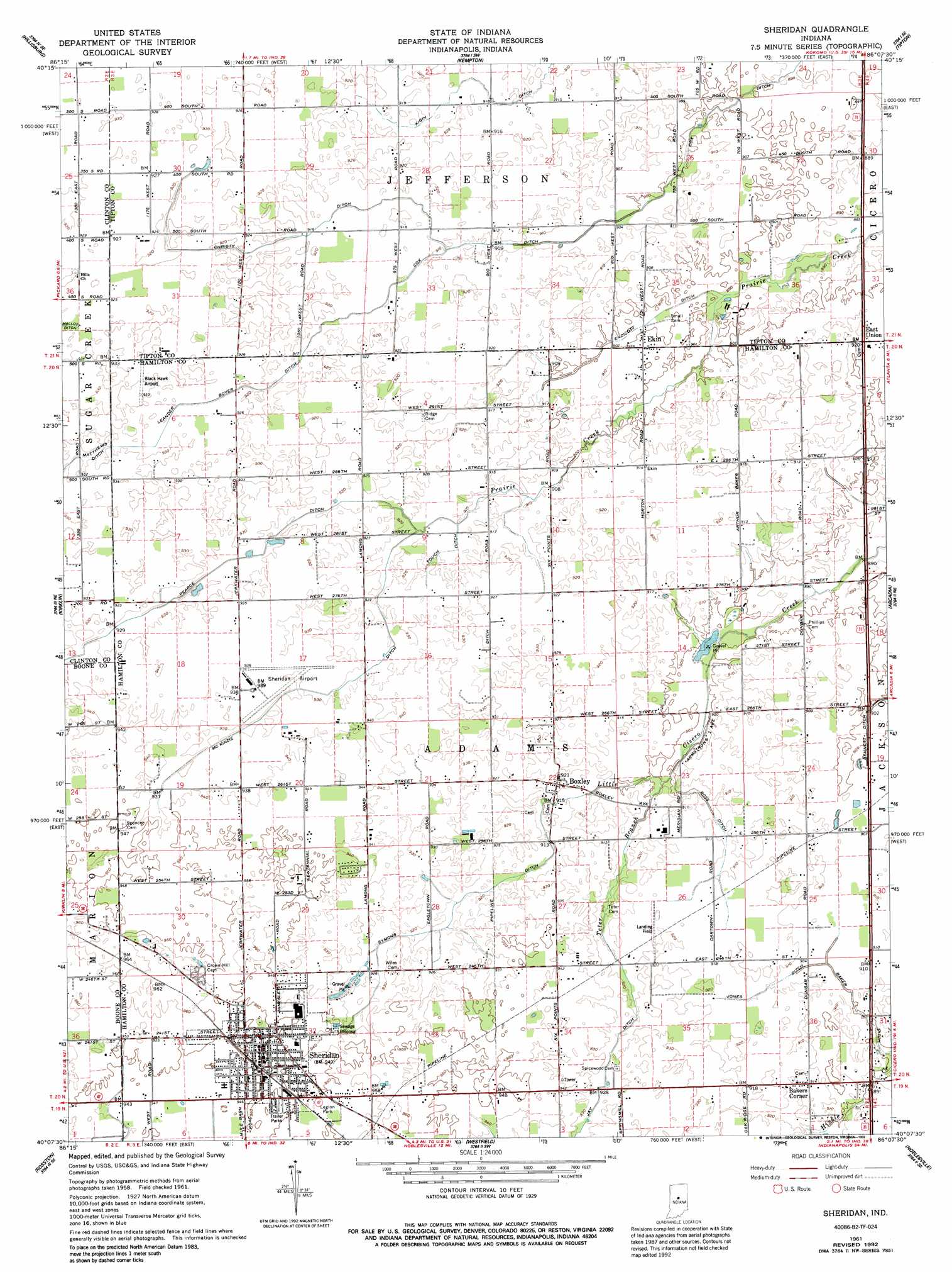
USGS Topo Quad 40086b2 - 1:24,000 scale
| Topo Map Name: | Sheridan |
| USGS Topo Quad ID: | 40086b2 |
| Print Size: | ca. 21 1/4" wide x 27" high |
| Southeast Coordinates: | 40.125° N latitude / 86.125° W longitude |
| Map Center Coordinates: | 40.1875° N latitude / 86.1875° W longitude |
| U.S. State: | IN |
| Filename: | o40086b2.jpg |
| Download Map JPG Image: | Sheridan topo map 1:24,000 scale |
| Map Type: | Topographic |
| Topo Series: | 7.5´ |
| Map Scale: | 1:24,000 |
| Source of Map Images: | United States Geological Survey (USGS) |
| Alternate Map Versions: |
Sheridan IN 1961, updated 1962 Download PDF Buy paper map Sheridan IN 1961, updated 1987 Download PDF Buy paper map Sheridan IN 1961, updated 1992 Download PDF Buy paper map Sheridan IN 2010 Download PDF Buy paper map Sheridan IN 2013 Download PDF Buy paper map Sheridan IN 2016 Download PDF Buy paper map |
1:24,000 Topo Quads surrounding Sheridan
Burlington |
Russiaville |
Kokomo West |
Kokomo East |
Greentown |
Michigantown |
Hillisburg |
Kempton |
Tipton |
Windfall |
Mechanicsburg |
Kirklin |
Sheridan |
Arcadia |
Omega |
Lebanon |
Rosston |
Westfield |
Noblesville |
Riverwood |
Fayette |
Zionsville |
Carmel |
Fishers |
Mccordsville |
> Back to 40086a1 at 1:100,000 scale
> Back to 40086a1 at 1:250,000 scale
> Back to U.S. Topo Maps home
Sheridan topo map: Gazetteer
Sheridan: Airports
Black Hawk Airport elevation 283m 928′Sheridan Airport elevation 283m 928′
Windy Knoll Airport elevation 280m 918′
Sheridan: Canals
Baker Ditch elevation 274m 898′Christy Ditch elevation 279m 915′
Cox Ditch elevation 273m 895′
Endicott Ditch elevation 273m 895′
Fouch Ditch elevation 279m 915′
Jay Ditch elevation 282m 925′
Jones Ditch elevation 277m 908′
Leander Boyer Ditch elevation 280m 918′
McKinzie Ditch elevation 283m 928′
Pearce Ditch elevation 282m 925′
Ross Ditch elevation 277m 908′
Symons Ditch elevation 280m 918′
Sheridan: Parks
Legion Park elevation 290m 951′Sheridan: Populated Places
Bakers Corner elevation 279m 915′Boxley elevation 280m 918′
East Union elevation 278m 912′
Ekin elevation 276m 905′
Sheridan elevation 289m 948′
Sheridan: Streams
Teter Branch elevation 274m 898′Sheridan digital topo map on disk
Buy this Sheridan topo map showing relief, roads, GPS coordinates and other geographical features, as a high-resolution digital map file on DVD:
Northern Illinois, Northern Indiana & Southwestern Michigan
Buy digital topo maps: Northern Illinois, Northern Indiana & Southwestern Michigan