Kokomo East Topo Map Indiana
To zoom in, hover over the map of Kokomo East
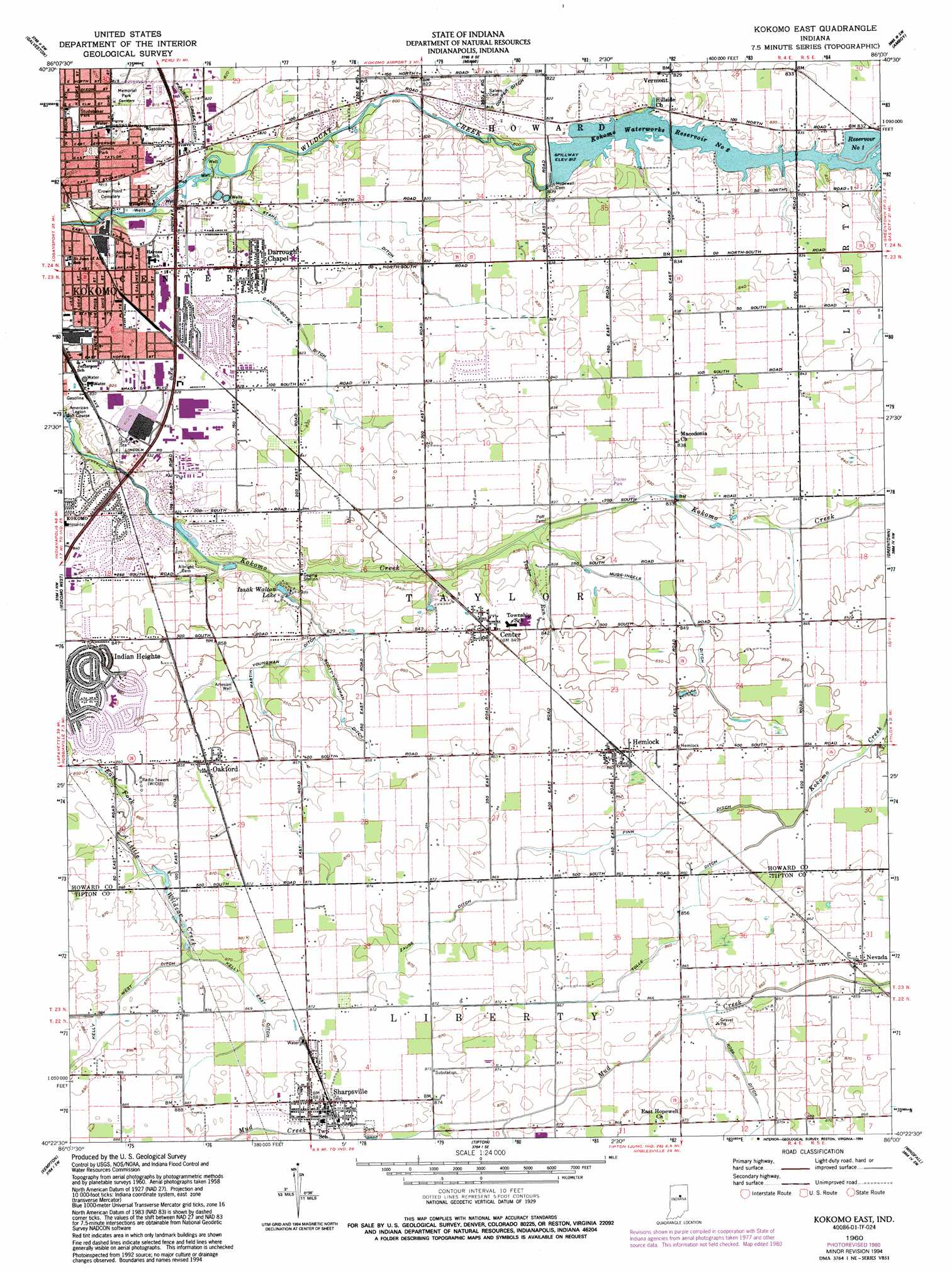
USGS Topo Quad 40086d1 - 1:24,000 scale
| Topo Map Name: | Kokomo East |
| USGS Topo Quad ID: | 40086d1 |
| Print Size: | ca. 21 1/4" wide x 27" high |
| Southeast Coordinates: | 40.375° N latitude / 86° W longitude |
| Map Center Coordinates: | 40.4375° N latitude / 86.0625° W longitude |
| U.S. State: | IN |
| Filename: | o40086d1.jpg |
| Download Map JPG Image: | Kokomo East topo map 1:24,000 scale |
| Map Type: | Topographic |
| Topo Series: | 7.5´ |
| Map Scale: | 1:24,000 |
| Source of Map Images: | United States Geological Survey (USGS) |
| Alternate Map Versions: |
Kokomo East IN 1960, updated 1961 Download PDF Buy paper map Kokomo East IN 1960, updated 1980 Download PDF Buy paper map Kokomo East IN 1960, updated 1994 Download PDF Buy paper map Kokomo East IN 2010 Download PDF Buy paper map Kokomo East IN 2013 Download PDF Buy paper map Kokomo East IN 2016 Download PDF Buy paper map |
1:24,000 Topo Quads surrounding Kokomo East
Anoka |
Onward |
Bunker Hill |
Peoria |
Somerset |
Young America |
Galveston |
Miami |
Amboy |
Sweetser |
Russiaville |
Kokomo West |
Kokomo East |
Greentown |
Point Isabel |
Hillisburg |
Kempton |
Tipton |
Windfall |
Elwood |
Kirklin |
Sheridan |
Arcadia |
Omega |
Frankton |
> Back to 40086a1 at 1:100,000 scale
> Back to 40086a1 at 1:250,000 scale
> Back to U.S. Topo Maps home
Kokomo East topo map: Gazetteer
Kokomo East: Airports
Medallion Field elevation 253m 830′Kokomo East: Canals
Cannon-Goyer Ditch elevation 250m 820′Copper Ditch elevation 247m 810′
Finn Ditch elevation 261m 856′
Kelly East Ditch elevation 266m 872′
Martin-Youngman Ditch elevation 252m 826′
Mugg-Ingels Ditch elevation 255m 836′
Ross Ditch elevation 263m 862′
Scott-Youngman Ditch elevation 256m 839′
Stahl Ditch elevation 249m 816′
Tolle Ditch elevation 259m 849′
Zauss Ditch elevation 263m 862′
Kokomo East: Dams
Kokomo Waterworks Dam Number 2 elevation 248m 813′Kokomo East: Parks
Somers Park elevation 244m 800′Studebaker Park elevation 250m 820′
Kokomo East: Populated Places
Center elevation 258m 846′Darrough Chapel elevation 250m 820′
Hemlock elevation 263m 862′
Nevada elevation 263m 862′
Oakford elevation 262m 859′
Sharpsville elevation 268m 879′
Vermont elevation 253m 830′
Kokomo East: Reservoirs
Kokomo Reservoir Number One elevation 254m 833′Kokomo Waterworks Reservoir Number Two elevation 248m 813′
Kokomo East: Streams
North Creek elevation 263m 862′Taylor Run elevation 250m 820′
Kokomo East digital topo map on disk
Buy this Kokomo East topo map showing relief, roads, GPS coordinates and other geographical features, as a high-resolution digital map file on DVD:
Northern Illinois, Northern Indiana & Southwestern Michigan
Buy digital topo maps: Northern Illinois, Northern Indiana & Southwestern Michigan