Pyrmont Topo Map Indiana
To zoom in, hover over the map of Pyrmont
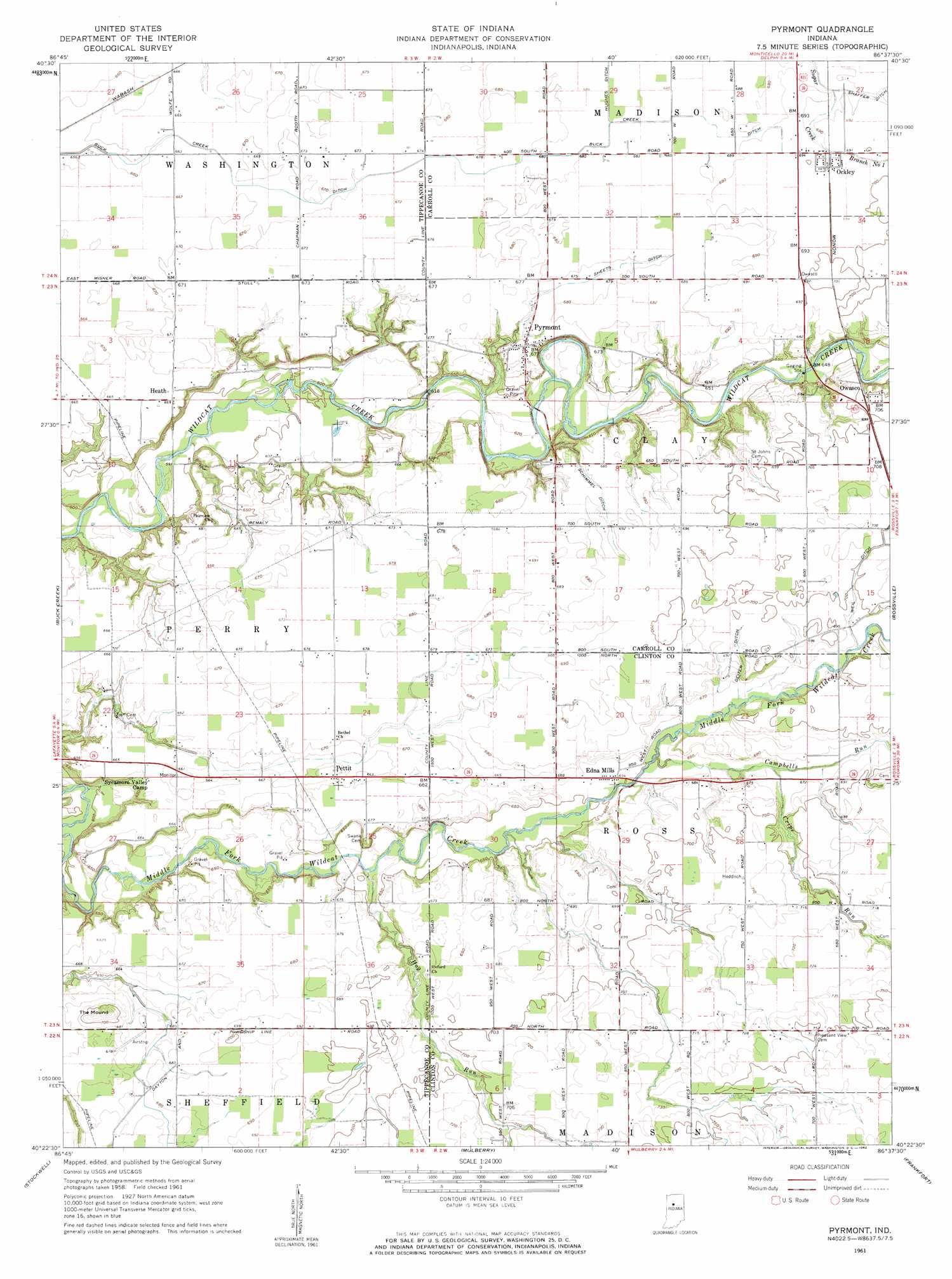
USGS Topo Quad 40086d6 - 1:24,000 scale
| Topo Map Name: | Pyrmont |
| USGS Topo Quad ID: | 40086d6 |
| Print Size: | ca. 21 1/4" wide x 27" high |
| Southeast Coordinates: | 40.375° N latitude / 86.625° W longitude |
| Map Center Coordinates: | 40.4375° N latitude / 86.6875° W longitude |
| U.S. State: | IN |
| Filename: | o40086d6.jpg |
| Download Map JPG Image: | Pyrmont topo map 1:24,000 scale |
| Map Type: | Topographic |
| Topo Series: | 7.5´ |
| Map Scale: | 1:24,000 |
| Source of Map Images: | United States Geological Survey (USGS) |
| Alternate Map Versions: |
Pyrmont IN 1961, updated 1962 Download PDF Buy paper map Pyrmont IN 1961, updated 1962 Download PDF Buy paper map Pyrmont IN 2010 Download PDF Buy paper map Pyrmont IN 2013 Download PDF Buy paper map Pyrmont IN 2016 Download PDF Buy paper map |
1:24,000 Topo Quads surrounding Pyrmont
Brookston Nw |
Monticello South |
Yeoman |
Burrows |
Clymers |
Brookston Sw |
Brookston |
Delphi |
Flora |
Deer Creek |
Lafayette West |
Lafayette East |
Pyrmont |
Rossville |
Burlington |
Romney |
Stockwell |
Mulberry |
Frankfort |
Michigantown |
Linden |
Kirkpatrick |
Colfax |
Thorntown |
Mechanicsburg |
> Back to 40086a1 at 1:100,000 scale
> Back to 40086a1 at 1:250,000 scale
> Back to U.S. Topo Maps home
Pyrmont topo map: Gazetteer
Pyrmont: Airports
Barnhart Strip Airport elevation 212m 695′Pyrmont: Canals
Buck Creek Ditch elevation 205m 672′Deiter Ditch elevation 208m 682′
Schimnel Ditch elevation 206m 675′
Shaftey Ditch elevation 209m 685′
Sheets Ditch elevation 205m 672′
Weil Ditch elevation 212m 695′
Pyrmont: Parks
Sycamore Valley Camp elevation 186m 610′Pyrmont: Populated Places
Edna Mills elevation 199m 652′Heath elevation 204m 669′
Ockley elevation 211m 692′
Owasco elevation 215m 705′
Pettit elevation 205m 672′
Pyrmont elevation 207m 679′
Pyrmont: Streams
Campbells Run elevation 198m 649′Cripe Run elevation 203m 666′
Dunk Creek elevation 196m 643′
Hog Run elevation 191m 626′
Pyrmont: Summits
The Mound elevation 222m 728′Pyrmont digital topo map on disk
Buy this Pyrmont topo map showing relief, roads, GPS coordinates and other geographical features, as a high-resolution digital map file on DVD:
Northern Illinois, Northern Indiana & Southwestern Michigan
Buy digital topo maps: Northern Illinois, Northern Indiana & Southwestern Michigan