Danville Sw Topo Map Illinois
To zoom in, hover over the map of Danville Sw
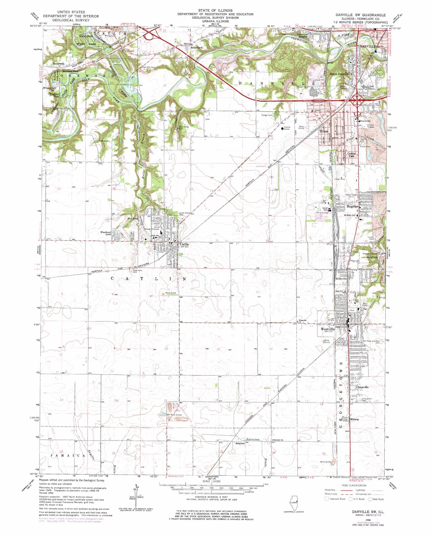
USGS Topo Quad 40087a6 - 1:24,000 scale
| Topo Map Name: | Danville Sw |
| USGS Topo Quad ID: | 40087a6 |
| Print Size: | ca. 21 1/4" wide x 27" high |
| Southeast Coordinates: | 40° N latitude / 87.625° W longitude |
| Map Center Coordinates: | 40.0625° N latitude / 87.6875° W longitude |
| U.S. State: | IL |
| Filename: | o40087a6.jpg |
| Download Map JPG Image: | Danville Sw topo map 1:24,000 scale |
| Map Type: | Topographic |
| Topo Series: | 7.5´ |
| Map Scale: | 1:24,000 |
| Source of Map Images: | United States Geological Survey (USGS) |
| Alternate Map Versions: |
Danville SW IL 1949, updated 1960 Download PDF Buy paper map Danville SW IL 1949, updated 1965 Download PDF Buy paper map Danville SW IL 1950 Download PDF Buy paper map Danville SW IL 1966, updated 1967 Download PDF Buy paper map Danville SW IL 1966, updated 1978 Download PDF Buy paper map Danville SW IL 2012 Download PDF Buy paper map Danville SW IL 2015 Download PDF Buy paper map |
1:24,000 Topo Quads surrounding Danville Sw
Penfield |
Potomac |
Henning |
Bismarck |
West Lebanon |
Royal |
Collison |
Danville Nw |
Danville Ne |
Covington |
Homer |
Oakwood |
Danville Sw |
Danville Se |
Perrysville |
Allerton |
Sidell |
Georgetown |
Humrick |
Newport |
Newman |
Hume |
Chrisman |
Scottland |
Dana |
> Back to 40087a1 at 1:100,000 scale
> Back to 40086a1 at 1:250,000 scale
> Back to U.S. Topo Maps home
Danville Sw topo map: Gazetteer
Danville Sw: Crossings
Interchange 210 elevation 197m 646′Interchange 214 elevation 198m 649′
Interchange 215 elevation 187m 613′
Danville Sw: Lakes
Doughnut Pond elevation 166m 544′Highway Pond elevation 165m 541′
Missionfield Pond elevation 166m 544′
Peelman Pond elevation 166m 544′
Rice Lake elevation 190m 623′
Woodland Lake elevation 197m 646′
Danville Sw: Mines
Deep Valley Mine elevation 181m 593′V-Day Mine elevation 198m 649′
Danville Sw: Parks
Central Park elevation 197m 646′Danville Stadium elevation 191m 626′
Kickapoo State Park elevation 188m 616′
Danville Sw: Populated Places
Batestown elevation 198m 649′Belgium elevation 199m 652′
Bucktown elevation 196m 643′
Catlin elevation 201m 659′
Danville elevation 183m 600′
Hegeler elevation 199m 652′
Kellyville elevation 204m 669′
Midway elevation 207m 679′
South Danville elevation 195m 639′
Steelton elevation 204m 669′
Tilton elevation 196m 643′
Unionville elevation 206m 675′
Vandercook elevation 196m 643′
Vermilion Heights elevation 184m 603′
Westville elevation 204m 669′
Danville Sw: Post Offices
Catlin Post Office elevation 201m 659′Westville Post Office elevation 204m 669′
Danville Sw: Streams
Butler Branch elevation 162m 531′Middle Fork Vermilion River elevation 163m 534′
North Fork Vermilion River elevation 158m 518′
Salt Fork elevation 163m 534′
Danville Sw: Valleys
Thompson Hollow elevation 161m 528′Danville Sw digital topo map on disk
Buy this Danville Sw topo map showing relief, roads, GPS coordinates and other geographical features, as a high-resolution digital map file on DVD:
Northern Illinois, Northern Indiana & Southwestern Michigan
Buy digital topo maps: Northern Illinois, Northern Indiana & Southwestern Michigan