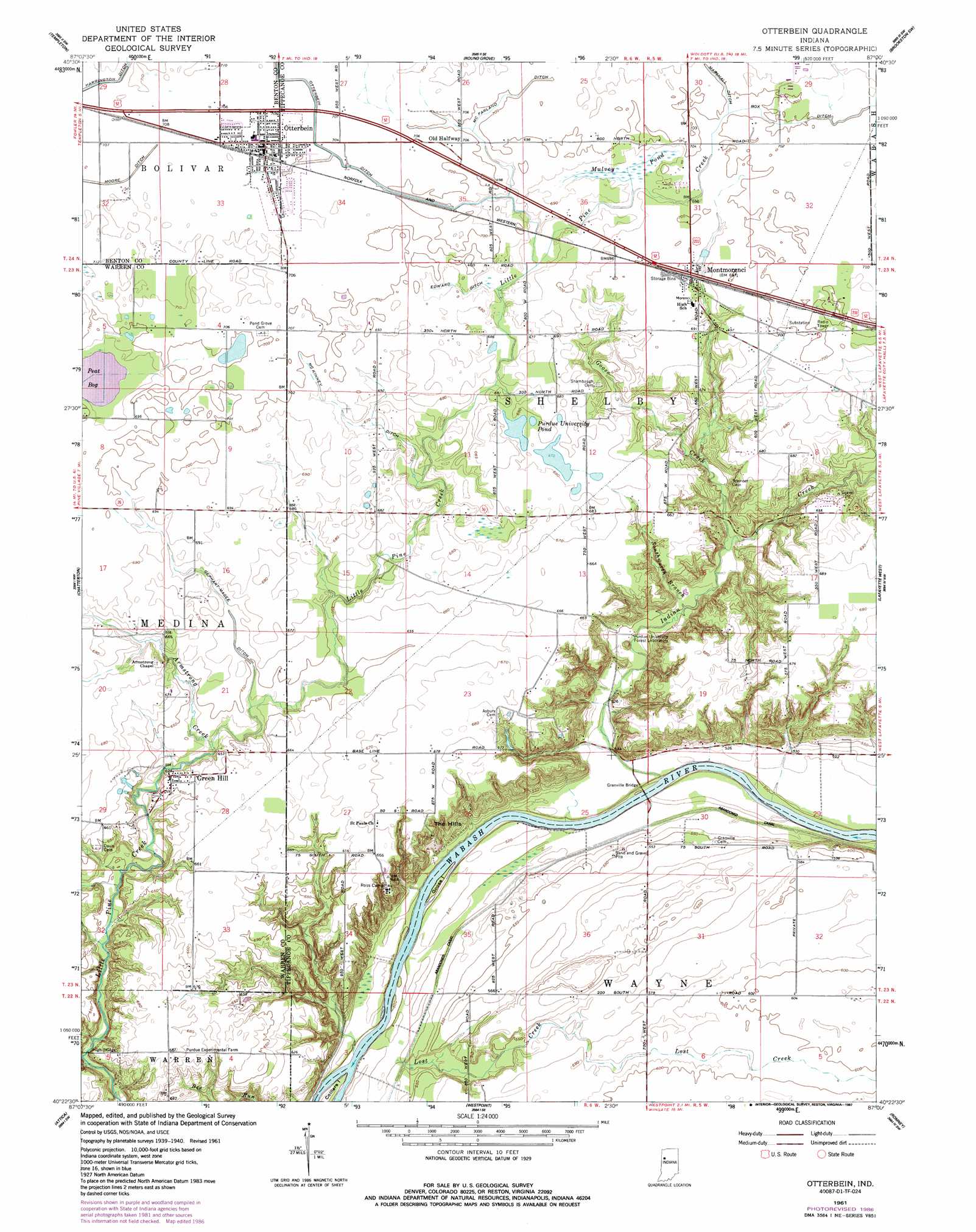
Otterbein Topo Map Indiana
To zoom in, hover over the map of Otterbein
USGS Topo Quad 40087d1 - 1:24,000 scale
| Topo Map Name: | Otterbein |
| USGS Topo Quad ID: | 40087d1 |
| Print Size: | ca. 21 1/4" wide x 27" high |
| Southeast Coordinates: | 40.375° N latitude / 87° W longitude |
| Map Center Coordinates: | 40.4375° N latitude / 87.0625° W longitude |
| U.S. State: | IN |
| Filename: | o40087d1.jpg |
| Download Map JPG Image: | Otterbein topo map 1:24,000 scale |
| Map Type: | Topographic |
| Topo Series: | 7.5´ |
| Map Scale: | 1:24,000 |
| Source of Map Images: | United States Geological Survey (USGS) |
| Alternate Map Versions: |
Otterbein IN 1942 Download PDF Buy paper map Otterbein IN 1951 Download PDF Buy paper map Otterbein IN 1961, updated 1963 Download PDF Buy paper map Otterbein IN 1961, updated 1963 Download PDF Buy paper map Otterbein IN 1961, updated 1987 Download PDF Buy paper map Otterbein IN 2010 Download PDF Buy paper map Otterbein IN 2013 Download PDF Buy paper map Otterbein IN 2016 Download PDF Buy paper map |
1:24,000 Topo Quads surrounding Otterbein
Wadena |
Mount Gilboa |
Templeton Ne |
Brookston Nw |
Monticello South |
Fowler |
Templeton |
Round Grove |
Brookston Sw |
Brookston |
Pine Village |
Chatterton |
Otterbein |
Lafayette West |
Lafayette East |
Williamsport |
Attica |
Westpoint |
Romney |
Stockwell |
Stone Bluff |
Mellott |
Wingate |
Linden |
Kirkpatrick |
> Back to 40087a1 at 1:100,000 scale
> Back to 40086a1 at 1:250,000 scale
> Back to U.S. Topo Maps home
Otterbein topo map: Gazetteer
Otterbein: Bridges
Grandville Bridge elevation 156m 511′Granville Bridge elevation 155m 508′
High Bridge elevation 174m 570′
Otterbein: Canals
Box Ditch elevation 213m 698′Edward Ditch elevation 211m 692′
Gephart-Mageet Ditch elevation 200m 656′
McFarland Ditch elevation 213m 698′
McKinney Ditch elevation 204m 669′
Otterbein Ditch elevation 215m 705′
Otterbein: Islands
Colliers Island elevation 155m 508′Goose Island elevation 156m 511′
Otterbein: Parks
Ross Camp elevation 201m 659′Otterbein: Populated Places
Green Hill elevation 200m 656′Montmorenci elevation 213m 698′
Old Halfway elevation 214m 702′
Otterbein elevation 216m 708′
Otterbein: Reservoirs
Purdue University Pond elevation 205m 672′Otterbein: Streams
Armstrong Creek elevation 191m 626′Goose Creek elevation 172m 564′
Indian Creek elevation 154m 505′
Lost Creek elevation 156m 511′
Southworth Branch elevation 166m 544′
Otterbein: Swamps
Mulvey Pond elevation 208m 682′Otterbein digital topo map on disk
Buy this Otterbein topo map showing relief, roads, GPS coordinates and other geographical features, as a high-resolution digital map file on DVD:
Northern Illinois, Northern Indiana & Southwestern Michigan
Buy digital topo maps: Northern Illinois, Northern Indiana & Southwestern Michigan