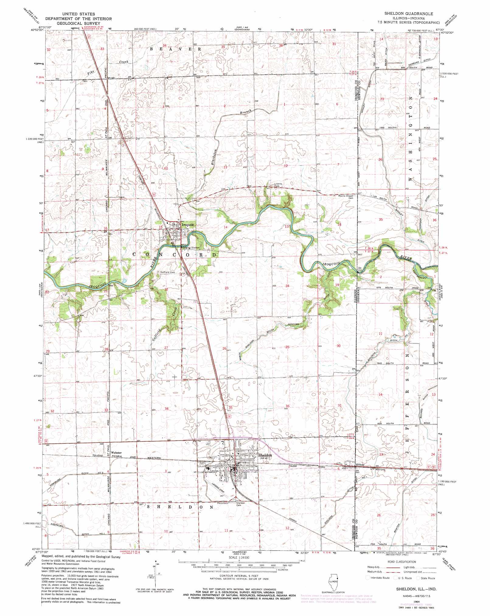
Sheldon Topo Map Illinois
To zoom in, hover over the map of Sheldon
USGS Topo Quad 40087g5 - 1:24,000 scale
| Topo Map Name: | Sheldon |
| USGS Topo Quad ID: | 40087g5 |
| Print Size: | ca. 21 1/4" wide x 27" high |
| Southeast Coordinates: | 40.75° N latitude / 87.5° W longitude |
| Map Center Coordinates: | 40.8125° N latitude / 87.5625° W longitude |
| U.S. States: | IL, IN |
| Filename: | o40087g5.jpg |
| Download Map JPG Image: | Sheldon topo map 1:24,000 scale |
| Map Type: | Topographic |
| Topo Series: | 7.5´ |
| Map Scale: | 1:24,000 |
| Source of Map Images: | United States Geological Survey (USGS) |
| Alternate Map Versions: |
Sheldon IL 1964, updated 1965 Download PDF Buy paper map Sheldon IL 1964, updated 1978 Download PDF Buy paper map Sheldon IL 1964, updated 1981 Download PDF Buy paper map Sheldon IL 2010 Download PDF Buy paper map Sheldon IL 2012 Download PDF Buy paper map Sheldon IL 2015 Download PDF Buy paper map |
1:24,000 Topo Quads surrounding Sheldon
Kankakee |
Saint Anne |
Leesville |
Enos |
Fair Oaks |
L'Erable |
Beaverville |
Donovan |
Morocco |
Mount Ayr |
Crescent |
Watseka |
Sheldon |
Kentland |
Goodland |
Woodworth |
Milford |
Darrow |
Earl Park |
Wadena |
Claytonville |
Wellington |
Stockland |
Boswell |
Fowler |
> Back to 40087e1 at 1:100,000 scale
> Back to 40086a1 at 1:250,000 scale
> Back to U.S. Topo Maps home
Sheldon topo map: Gazetteer
Sheldon: Airports
Zoomer Field elevation 205m 672′Sheldon: Canals
Baird Ditch elevation 201m 659′Bowton Ditch elevation 207m 679′
Eastburn Ditch Number 1 elevation 206m 675′
Eastburn Ditch Number 2 elevation 206m 675′
North Sheldon South Concord Ditch elevation 196m 643′
S Garrard Ditch elevation 200m 656′
Sheldon Ditch elevation 203m 666′
Sheldon Ditch Number 1 elevation 202m 662′
Whaley Ditch elevation 200m 656′
Sheldon: Populated Places
Effner elevation 207m 679′Effner elevation 208m 682′
Iroquois elevation 201m 659′
Sheldon elevation 208m 682′
Webster elevation 208m 682′
Sheldon: Streams
Blackston Branch elevation 190m 623′Gaffield Creek elevation 189m 620′
Sheldon digital topo map on disk
Buy this Sheldon topo map showing relief, roads, GPS coordinates and other geographical features, as a high-resolution digital map file on DVD:
Northern Illinois, Northern Indiana & Southwestern Michigan
Buy digital topo maps: Northern Illinois, Northern Indiana & Southwestern Michigan