Monticello Topo Map Illinois
To zoom in, hover over the map of Monticello
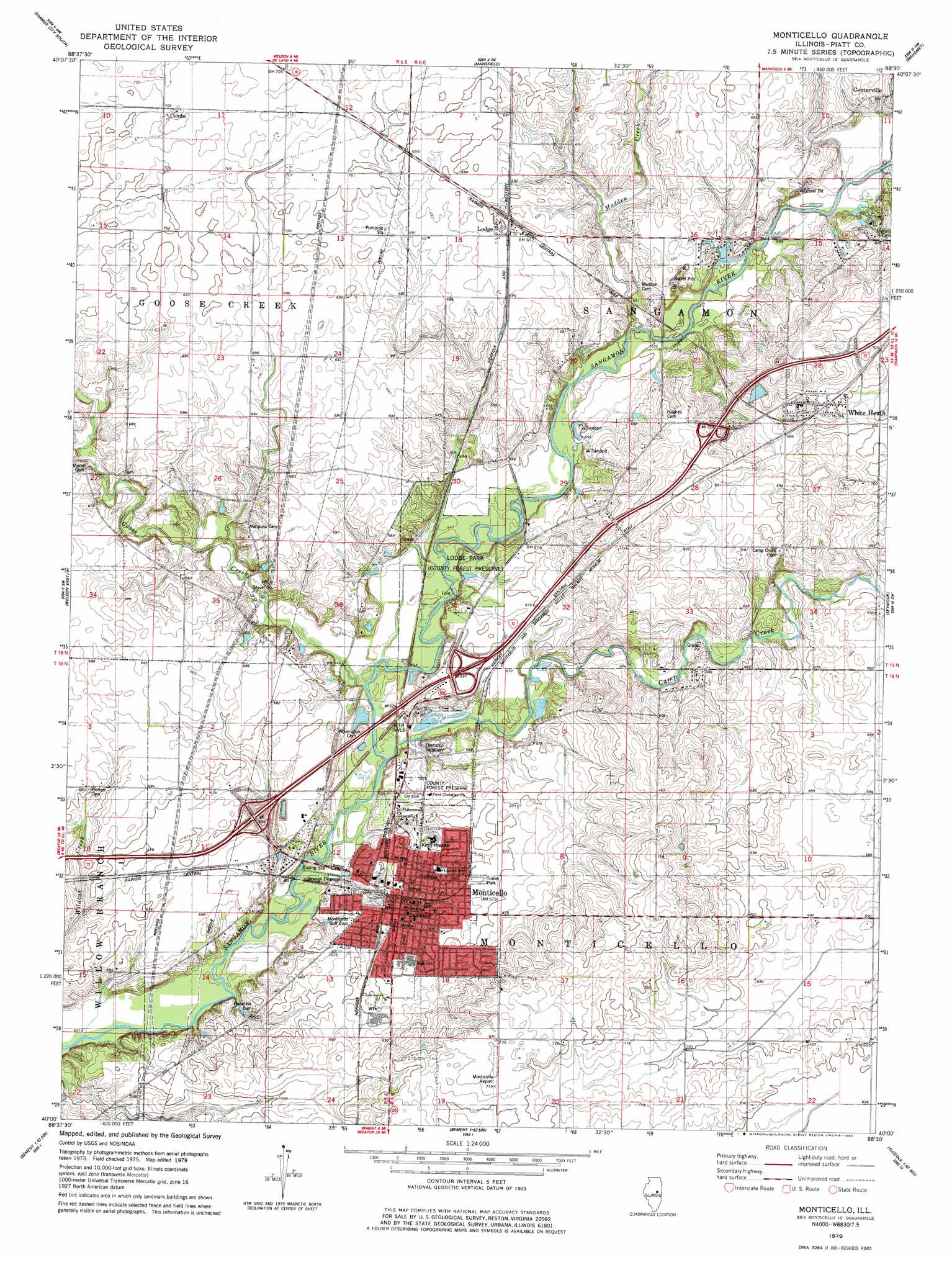
USGS Topo Quad 40088a5 - 1:24,000 scale
| Topo Map Name: | Monticello |
| USGS Topo Quad ID: | 40088a5 |
| Print Size: | ca. 21 1/4" wide x 27" high |
| Southeast Coordinates: | 40° N latitude / 88.5° W longitude |
| Map Center Coordinates: | 40.0625° N latitude / 88.5625° W longitude |
| U.S. State: | IL |
| Filename: | o40088a5.jpg |
| Download Map JPG Image: | Monticello topo map 1:24,000 scale |
| Map Type: | Topographic |
| Topo Series: | 7.5´ |
| Map Scale: | 1:24,000 |
| Source of Map Images: | United States Geological Survey (USGS) |
| Alternate Map Versions: |
Monticello IL 1979, updated 1980 Download PDF Buy paper map Monticello IL 2012 Download PDF Buy paper map Monticello IL 2015 Download PDF Buy paper map |
1:24,000 Topo Quads surrounding Monticello
Le Roy |
Farmer City North |
Belleflower |
Foosland |
Fisher |
De Witt |
Farmer City South |
Mansfield |
Mahomet |
Rising |
Weldon West |
Weldon East |
Monticello |
Seymour |
Bondville |
Argenta |
Cerro Gordo |
Bement |
Ivesdale |
Tolono |
Long Creek |
La Place |
Hammond |
Atwood |
Tuscola |
> Back to 40088a1 at 1:100,000 scale
> Back to 40088a1 at 1:250,000 scale
> Back to U.S. Topo Maps home
Monticello topo map: Gazetteer
Monticello: Airports
Piatt County Airport elevation 224m 734′Monticello: Canals
Washington Elementary School elevation 206m 675′Monticello: Crossings
Interchange 61 elevation 205m 672′Interchange 63 elevation 206m 675′
Interchange 66 elevation 215m 705′
Monticello: Lakes
Buck Pond (historical) elevation 194m 636′Monticello: Parks
Forest Preserve Park elevation 204m 669′Lodge Park elevation 201m 659′
Monticello: Populated Places
Combs elevation 216m 708′Lodge elevation 213m 698′
Monticello elevation 201m 659′
White Heath elevation 220m 721′
Monticello: Post Offices
Monticello Post Office elevation 201m 659′White Heath Post Office elevation 215m 705′
Monticello: Streams
Camp Creek elevation 194m 636′Goose Creek elevation 194m 636′
Madden Creek elevation 196m 643′
Monticello digital topo map on disk
Buy this Monticello topo map showing relief, roads, GPS coordinates and other geographical features, as a high-resolution digital map file on DVD:
Northern Illinois, Northern Indiana & Southwestern Michigan
Buy digital topo maps: Northern Illinois, Northern Indiana & Southwestern Michigan