Bloomington East Topo Map Illinois
To zoom in, hover over the map of Bloomington East
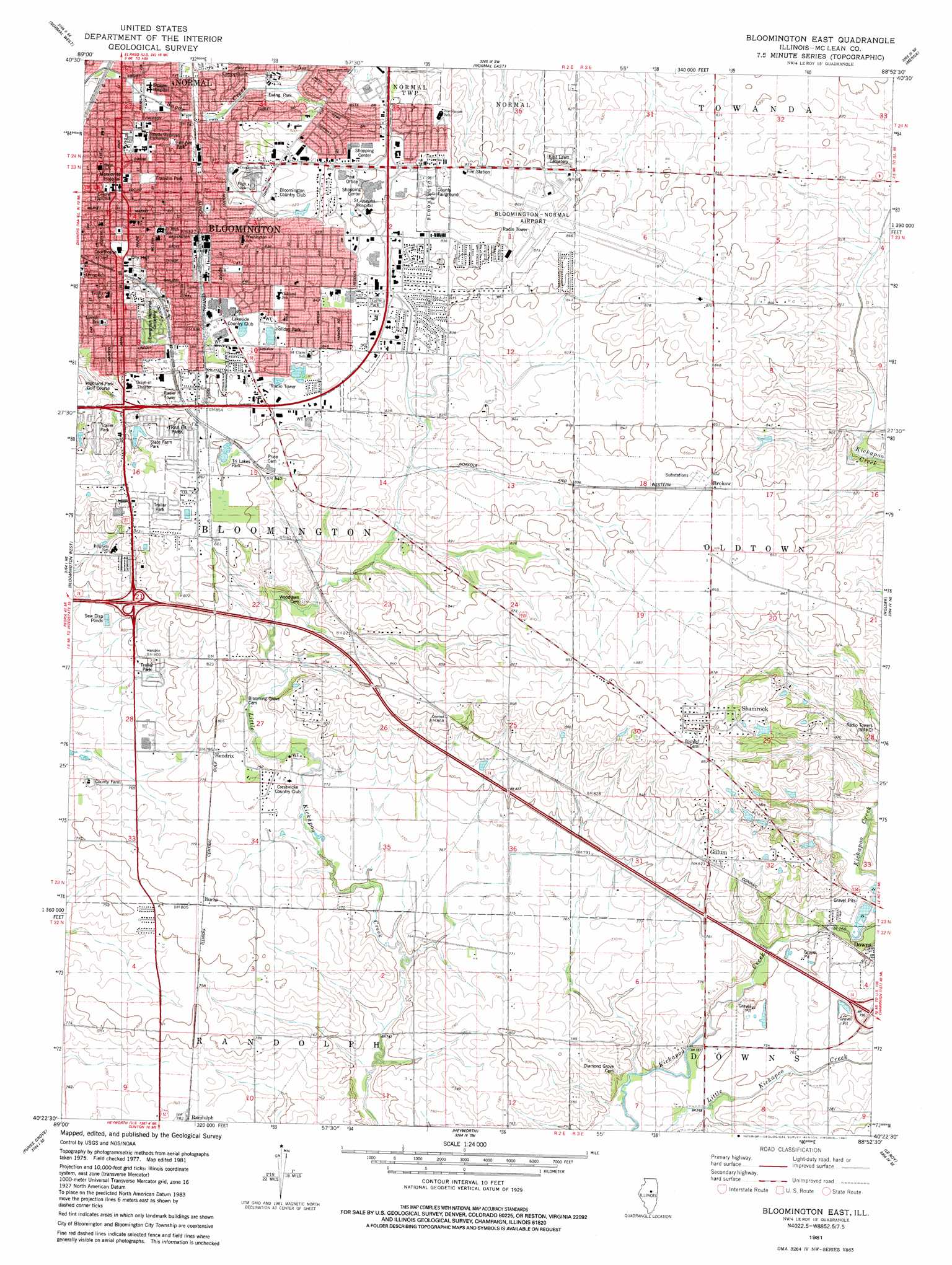
USGS Topo Quad 40088d8 - 1:24,000 scale
| Topo Map Name: | Bloomington East |
| USGS Topo Quad ID: | 40088d8 |
| Print Size: | ca. 21 1/4" wide x 27" high |
| Southeast Coordinates: | 40.375° N latitude / 88.875° W longitude |
| Map Center Coordinates: | 40.4375° N latitude / 88.9375° W longitude |
| U.S. State: | IL |
| Filename: | o40088d8.jpg |
| Download Map JPG Image: | Bloomington East topo map 1:24,000 scale |
| Map Type: | Topographic |
| Topo Series: | 7.5´ |
| Map Scale: | 1:24,000 |
| Source of Map Images: | United States Geological Survey (USGS) |
| Alternate Map Versions: |
Bloomington East IL 1981, updated 1981 Download PDF Buy paper map Bloomington East IL 1998, updated 2000 Download PDF Buy paper map Bloomington East IL 2012 Download PDF Buy paper map Bloomington East IL 2015 Download PDF Buy paper map |
1:24,000 Topo Quads surrounding Bloomington East
Secor |
El Paso |
Gridley |
Lexington |
Chenoa |
Danvers |
Normal West |
Normal East |
Merna |
Cooksville |
Stanford |
Bloomington West |
Bloomington East |
Holder |
Arrowsmith |
Mclean |
Funks Grove |
Heyworth |
Le Roy |
Farmer City North |
Waynesville West |
Waynesville East |
Clinton |
De Witt |
Farmer City South |
> Back to 40088a1 at 1:100,000 scale
> Back to 40088a1 at 1:250,000 scale
> Back to U.S. Topo Maps home
Bloomington East topo map: Gazetteer
Bloomington East: Airports
Bloomington-Normal Airport elevation 264m 866′Davis RLA Heliport elevation 255m 836′
Saint Joseph Medical Center Heliport elevation 260m 853′
Bloomington East: Crossings
Interchange 135 elevation 251m 823′Interchange 142 elevation 238m 780′
Bloomington East: Parks
Ewing Park elevation 237m 777′Fell Avenue Park elevation 240m 787′
Franklin Park elevation 249m 816′
Holiday Park elevation 256m 839′
Mercherle Park elevation 258m 846′
Rollingbrook Park elevation 259m 849′
State Farm Park elevation 259m 849′
Tri Lakes Park elevation 259m 849′
White Place Historic District elevation 244m 800′
Wilder Field elevation 233m 764′
Bloomington East: Populated Places
Bloomington elevation 243m 797′Brokaw elevation 262m 859′
Burns elevation 245m 803′
Colonial Meadows elevation 259m 849′
Gillum elevation 254m 833′
Hendrix elevation 241m 790′
Hilltop Trailer Park elevation 259m 849′
Randolph elevation 238m 780′
Shamrock elevation 268m 879′
Southgate Estates Trailer Park elevation 267m 875′
Bloomington East: Post Offices
Bloomington Post Office elevation 255m 836′Bloomington East digital topo map on disk
Buy this Bloomington East topo map showing relief, roads, GPS coordinates and other geographical features, as a high-resolution digital map file on DVD:
Northern Illinois, Northern Indiana & Southwestern Michigan
Buy digital topo maps: Northern Illinois, Northern Indiana & Southwestern Michigan