Morton Topo Map Illinois
To zoom in, hover over the map of Morton
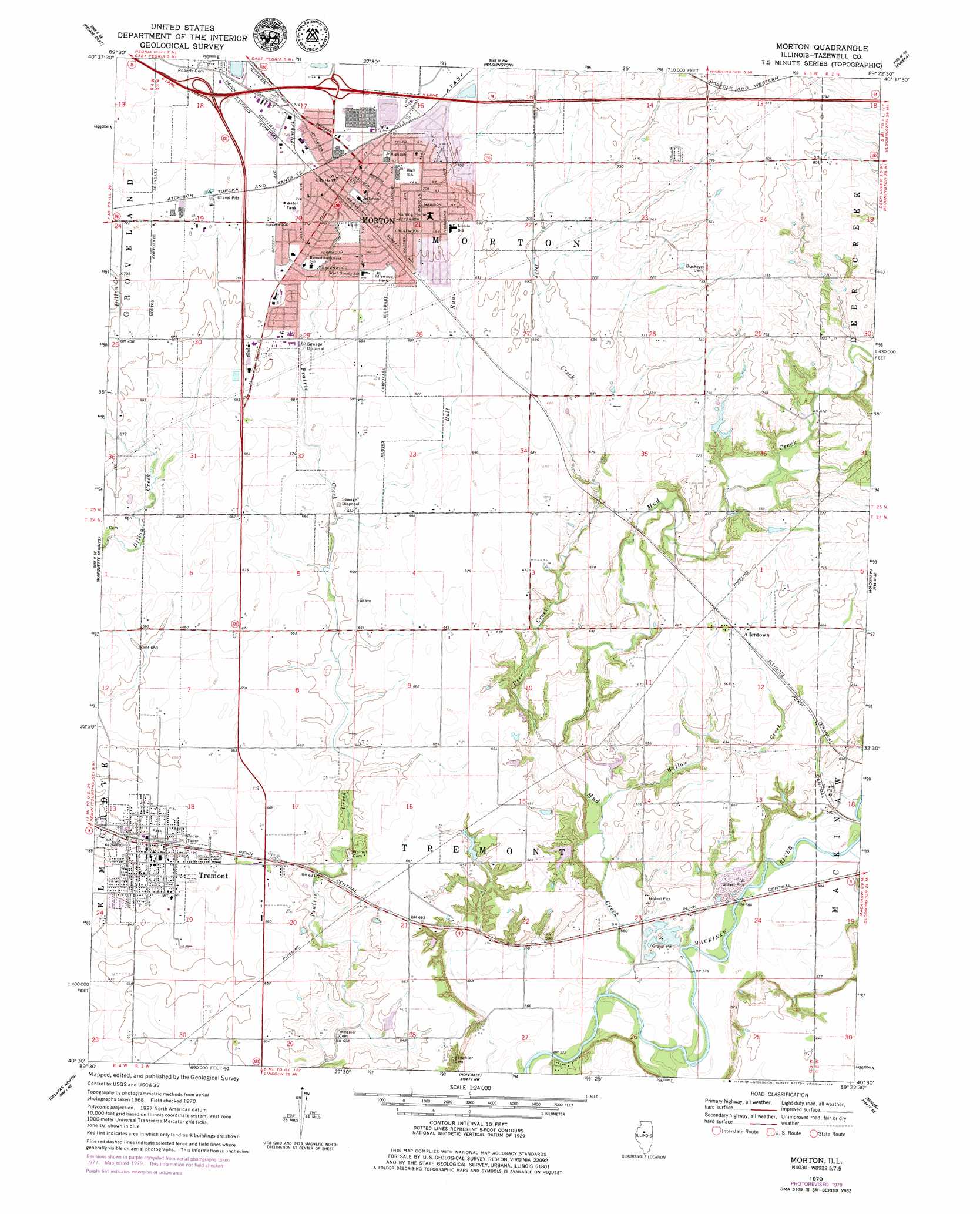
USGS Topo Quad 40089e4 - 1:24,000 scale
| Topo Map Name: | Morton |
| USGS Topo Quad ID: | 40089e4 |
| Print Size: | ca. 21 1/4" wide x 27" high |
| Southeast Coordinates: | 40.5° N latitude / 89.375° W longitude |
| Map Center Coordinates: | 40.5625° N latitude / 89.4375° W longitude |
| U.S. State: | IL |
| Filename: | o40089e4.jpg |
| Download Map JPG Image: | Morton topo map 1:24,000 scale |
| Map Type: | Topographic |
| Topo Series: | 7.5´ |
| Map Scale: | 1:24,000 |
| Source of Map Images: | United States Geological Survey (USGS) |
| Alternate Map Versions: |
Morton IL 1970, updated 1972 Download PDF Buy paper map Morton IL 1995, updated 1996 Download PDF Buy paper map Morton IL 2012 Download PDF Buy paper map Morton IL 2015 Download PDF Buy paper map |
1:24,000 Topo Quads surrounding Morton
Dunlap |
Spring Bay |
Germantown Hills |
Metamora |
Roanoke |
Peoria West |
Peoria East |
Washington |
Eureka |
Secor |
Pekin |
Marquette Heights |
Morton |
Mackinaw |
Danvers |
South Pekin |
Delavan North |
Hopedale |
Minier |
Stanford |
Natrona |
Delavan South |
Emden |
Armington |
Mclean |
> Back to 40089e1 at 1:100,000 scale
> Back to 40088a1 at 1:250,000 scale
> Back to U.S. Topo Maps home
Morton topo map: Gazetteer
Morton: Bridges
Vaughter Bridge elevation 173m 567′Morton: Crossings
Interchange 101 elevation 227m 744′Interchange 102 elevation 219m 718′
Interchange 28 elevation 207m 679′
Interchange 29 elevation 210m 688′
Interchange 30 elevation 214m 702′
Interchange 31 elevation 219m 718′
Morton: Dams
Boyles Lake Dam elevation 180m 590′Sutton Pond Dam elevation 199m 652′
Wilman Sportsman Club East Lake Dam elevation 213m 698′
Wilman Sportsman Club West Lake Dam elevation 213m 698′
Morton: Parks
Birchwood Park elevation 218m 715′Idlewood Park elevation 214m 702′
Southwood Park elevation 211m 692′
Morton: Populated Places
Allentown elevation 207m 679′Mayfair elevation 241m 790′
Morton elevation 218m 715′
Tremont elevation 196m 643′
Morton: Post Offices
Morton Post Office elevation 217m 711′Tremont Post Office elevation 199m 652′
Morton: Reservoirs
Boyles Lake elevation 180m 590′Sutton Pond elevation 199m 652′
Wilman Sportsman Club East Lake elevation 213m 698′
Wilman Sportsman Club West Lake elevation 213m 698′
Morton: Streams
Bull Run elevation 198m 649′Deer Creek elevation 181m 593′
Mud Creek elevation 171m 561′
Springhill Creek elevation 189m 620′
Willow Creek elevation 177m 580′
Morton digital topo map on disk
Buy this Morton topo map showing relief, roads, GPS coordinates and other geographical features, as a high-resolution digital map file on DVD:
Northern Illinois, Northern Indiana & Southwestern Michigan
Buy digital topo maps: Northern Illinois, Northern Indiana & Southwestern Michigan