Havana Topo Map Illinois
To zoom in, hover over the map of Havana
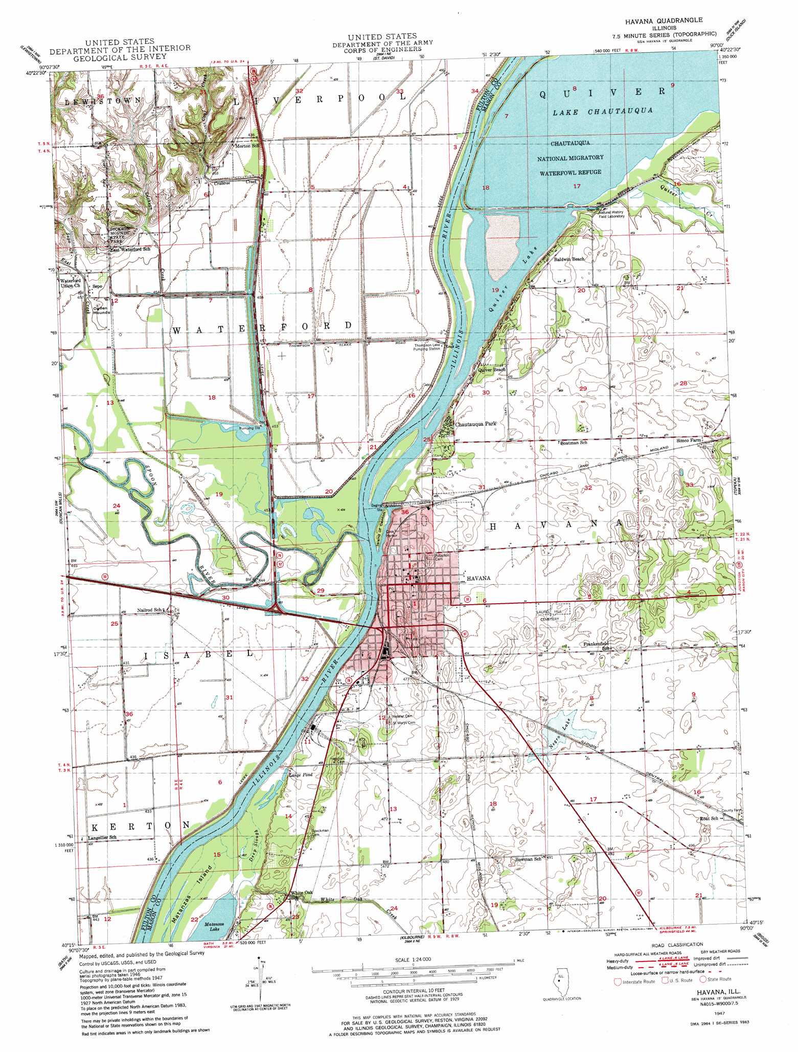
USGS Topo Quad 40090c1 - 1:24,000 scale
| Topo Map Name: | Havana |
| USGS Topo Quad ID: | 40090c1 |
| Print Size: | ca. 21 1/4" wide x 27" high |
| Southeast Coordinates: | 40.25° N latitude / 90° W longitude |
| Map Center Coordinates: | 40.3125° N latitude / 90.0625° W longitude |
| U.S. State: | IL |
| Filename: | o40090c1.jpg |
| Download Map JPG Image: | Havana topo map 1:24,000 scale |
| Map Type: | Topographic |
| Topo Series: | 7.5´ |
| Map Scale: | 1:24,000 |
| Source of Map Images: | United States Geological Survey (USGS) |
| Alternate Map Versions: |
Havana IL 1947, updated 1984 Download PDF Buy paper map Havana IL 1948 Download PDF Buy paper map Havana IL 2012 Download PDF Buy paper map Havana IL 2015 Download PDF Buy paper map |
1:24,000 Topo Quads surrounding Havana
Blyton |
Fiatt |
Canton |
Banner |
Glasford |
Smithfield |
Lewiston |
Saint David |
Duck Island |
Manito |
Ipava |
Duncan Mills |
Havana |
Topeka |
Forest City |
Astoria |
Bath |
Kilbourne |
Biggs |
Easton |
Clear Lake |
Chandlerville |
Newmansville |
Oakford |
Petersburg |
> Back to 40090a1 at 1:100,000 scale
> Back to 40090a1 at 1:250,000 scale
> Back to U.S. Topo Maps home
Havana topo map: Gazetteer
Havana: Airports
G Bray Airport elevation 154m 505′Mason District Hospital Heliport elevation 141m 462′
Norris Farms Airport elevation 132m 433′
Havana: Bays
Cook Harbor elevation 135m 442′Havana: Guts
Deep Slough elevation 135m 442′Havana: Islands
Island of Canton elevation 135m 442′Matanzas Island elevation 135m 442′
Havana: Lakes
Lange Pond elevation 135m 442′Negro Lake elevation 146m 479′
Quiver Lake elevation 136m 446′
Thompson Lake (historical) elevation 128m 419′
Havana: Parks
Chautaugua National Wildlife Refuge elevation 136m 446′Chautauqua National Migratory Waterfowl Refuge elevation 136m 446′
Dickson Mounds State Park elevation 166m 544′
H G Rice Park elevation 143m 469′
Riverfront Park elevation 136m 446′
Rockwell Park elevation 143m 469′
Havana: Populated Places
Baldwin Beach elevation 146m 479′Chautauqua Park elevation 145m 475′
Havana elevation 145m 475′
Quiver Beach elevation 142m 465′
Sepo elevation 138m 452′
Havana: Post Offices
Havana Post Office elevation 143m 469′Quiver Lake Post Office (historical) elevation 143m 469′
Havana: Streams
Coal Creek elevation 135m 442′Dickson Creek elevation 135m 442′
Quiver Creek elevation 136m 446′
Sepo Creek elevation 137m 449′
Spoon River elevation 135m 442′
White Oak Creek elevation 135m 442′
Havana digital topo map on disk
Buy this Havana topo map showing relief, roads, GPS coordinates and other geographical features, as a high-resolution digital map file on DVD: