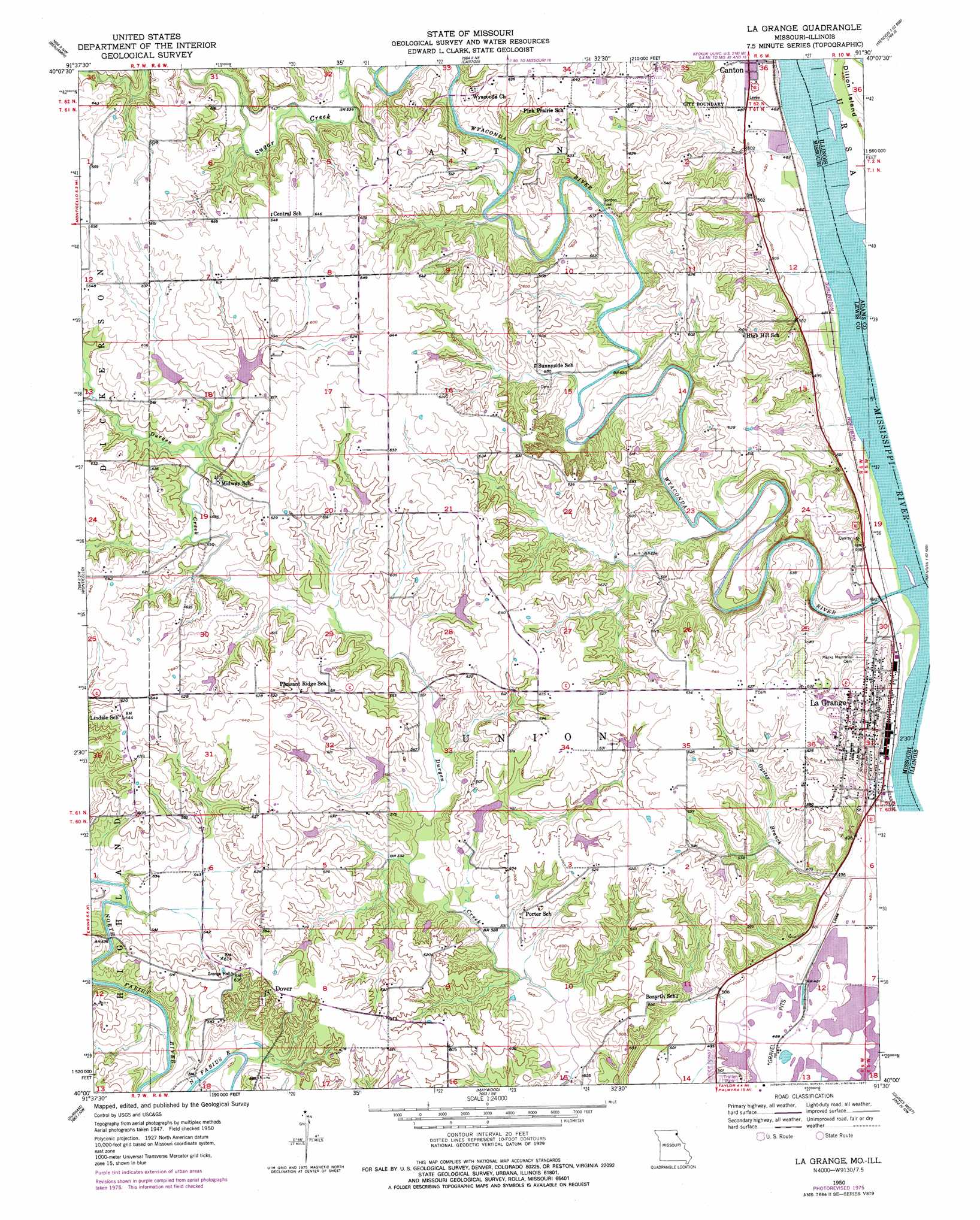
La Grange Topo Map Missouri
To zoom in, hover over the map of La Grange
USGS Topo Quad 40091a5 - 1:24,000 scale
| Topo Map Name: | La Grange |
| USGS Topo Quad ID: | 40091a5 |
| Print Size: | ca. 21 1/4" wide x 27" high |
| Southeast Coordinates: | 40° N latitude / 91.5° W longitude |
| Map Center Coordinates: | 40.0625° N latitude / 91.5625° W longitude |
| U.S. States: | MO, IL |
| Filename: | o40091a5.jpg |
| Download Map JPG Image: | La Grange topo map 1:24,000 scale |
| Map Type: | Topographic |
| Topo Series: | 7.5´ |
| Map Scale: | 1:24,000 |
| Source of Map Images: | United States Geological Survey (USGS) |
| Alternate Map Versions: |
La Grange MO 1950, updated 1959 Download PDF Buy paper map La Grange MO 1950, updated 1977 Download PDF Buy paper map La Grange MO 1951 Download PDF Buy paper map La Grange MO 2012 Download PDF Buy paper map La Grange MO 2015 Download PDF Buy paper map |
1:24,000 Topo Quads surrounding La Grange
Neeper |
Saint Patrick |
Kahoka Se |
Warsaw |
Sutter |
Williamstown |
Benjamin |
Canton |
Lima |
Tioga |
Lewistown |
Monticello |
La Grange |
Long Island |
Mendon |
Nelsonville |
Durham |
Maywood |
Quincy West |
Quincy East |
Emden |
Philadelphia |
Palmyra |
Quincy Sw |
Marblehead |
> Back to 40091a1 at 1:100,000 scale
> Back to 40090a1 at 1:250,000 scale
> Back to U.S. Topo Maps home
La Grange topo map: Gazetteer
La Grange: Airports
Windy Hill Airport elevation 164m 538′La Grange: Bridges
Wyaconda Church Bridge elevation 159m 521′La Grange: Crossings
Gordon Ford elevation 157m 515′La Grange: Dams
Durgens Creek Watershed Dam Number 1 A elevation 181m 593′Durgens Creek Watershed Dam Number 24 elevation 178m 583′
Durgens Creek Watershed Dam Number 32 elevation 171m 561′
Durgens Creek Watershed Dam Number 4 elevation 176m 577′
Durgens Creek Watershed Dam Number 5 elevation 168m 551′
Durgens Creek Watershed Dam Number 7 elevation 168m 551′
Durgens Creek Watershed Lake 1 B Dam elevation 183m 600′
Durgens Creek Watershed Number 23 Dam elevation 170m 557′
Durgens Creek Watershed Number 33 Dam elevation 178m 583′
Durgens Creek Watershed Number 34 Dam elevation 175m 574′
Durgens Creek Watershed Number 37 Dam elevation 183m 600′
Lewis County Number 38 Dam elevation 171m 561′
Solter Lake Dam elevation 181m 593′
La Grange: Parks
Wakonda State Park elevation 154m 505′La Grange: Populated Places
Dover elevation 190m 623′Weber elevation 181m 593′
La Grange: Reservoirs
Durgens Creek Watershed Lake 1 B elevation 183m 600′Durgens Creek Watershed Lake Number 1 A elevation 181m 593′
Durgens Creek Watershed Lake Number 4 elevation 176m 577′
Garkie Lake Section 32 elevation 168m 551′
Garkie Lake Section 8 elevation 171m 561′
Lake O'Vaughn elevation 170m 557′
Lewis County Number 33 Lake elevation 178m 583′
Scott Shaffer Lake Number 7 elevation 168m 551′
Solter Lake elevation 181m 593′
Todd Lake elevation 175m 574′
Tracy Lake elevation 178m 583′
Waganer Lake elevation 183m 600′
La Grange: Streams
Linn Branch elevation 156m 511′Sugar Creek elevation 159m 521′
La Grange digital topo map on disk
Buy this La Grange topo map showing relief, roads, GPS coordinates and other geographical features, as a high-resolution digital map file on DVD: