Lima Topo Map Illinois
To zoom in, hover over the map of Lima
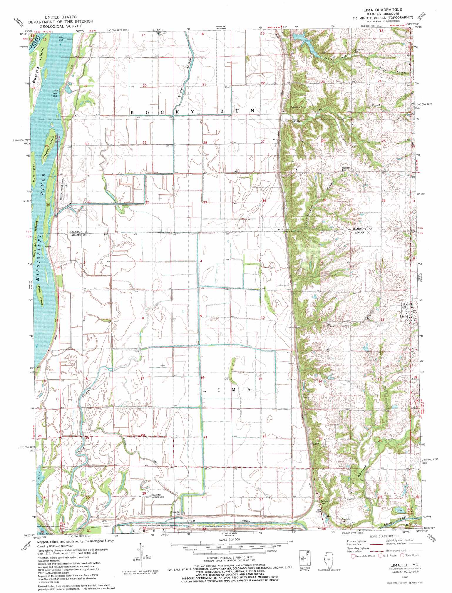
USGS Topo Quad 40091b4 - 1:24,000 scale
| Topo Map Name: | Lima |
| USGS Topo Quad ID: | 40091b4 |
| Print Size: | ca. 21 1/4" wide x 27" high |
| Southeast Coordinates: | 40.125° N latitude / 91.375° W longitude |
| Map Center Coordinates: | 40.1875° N latitude / 91.4375° W longitude |
| U.S. States: | IL, MO |
| Filename: | o40091b4.jpg |
| Download Map JPG Image: | Lima topo map 1:24,000 scale |
| Map Type: | Topographic |
| Topo Series: | 7.5´ |
| Map Scale: | 1:24,000 |
| Source of Map Images: | United States Geological Survey (USGS) |
| Alternate Map Versions: |
Lima IL 1981, updated 1981 Download PDF Buy paper map Lima IL 2012 Download PDF Buy paper map Lima IL 2015 Download PDF Buy paper map |
1:24,000 Topo Quads surrounding Lima
Kahoka |
Wayland |
Keokuk |
Hamilton |
Carthage West |
Saint Patrick |
Kahoka Se |
Warsaw |
Sutter |
West Point |
Benjamin |
Canton |
Lima |
Tioga |
Loraine |
Monticello |
La Grange |
Long Island |
Mendon |
Coatsburg |
Durham |
Maywood |
Quincy West |
Quincy East |
Columbus |
> Back to 40091a1 at 1:100,000 scale
> Back to 40090a1 at 1:250,000 scale
> Back to U.S. Topo Maps home
Lima topo map: Gazetteer
Lima: Airports
McAllister Landing Strip elevation 145m 475′Meeker Airport elevation 145m 475′
Lima: Canals
Bluff Canal elevation 154m 505′Seepage Ditch elevation 145m 475′
Lima: Dams
Jennifer Creek Reservoir Dam elevation 165m 541′Scheuermann Lake Dam elevation 177m 580′
Sill Lake Dam elevation 186m 610′
Lima: Guts
Cutoff Slough elevation 146m 479′Lima Slough elevation 143m 469′
Lima: Islands
Blue Goose Island elevation 149m 488′Buzzard Island elevation 148m 485′
Huff Island elevation 148m 485′
Hunt Island elevation 149m 488′
Mud Island elevation 149m 488′
Polly Island elevation 149m 488′
Lima: Lakes
Lima Lake (historical) elevation 143m 469′Martin Lake elevation 145m 475′
Lima: Mines
Lima Quarry elevation 153m 501′Lima: Populated Places
Lima elevation 199m 652′Lima: Reservoirs
Jennifer Creek Reservoir elevation 165m 541′Scheuermann Lake elevation 177m 580′
Sill Lake elevation 186m 610′
Lima: Streams
Bear Creek elevation 146m 479′Buel Branch elevation 152m 498′
County Line Branch elevation 153m 501′
Jenifer Creek elevation 153m 501′
Petit Creek elevation 157m 515′
Shipe Creek elevation 184m 603′
Whiteoak Creek elevation 151m 495′
Lima digital topo map on disk
Buy this Lima topo map showing relief, roads, GPS coordinates and other geographical features, as a high-resolution digital map file on DVD: