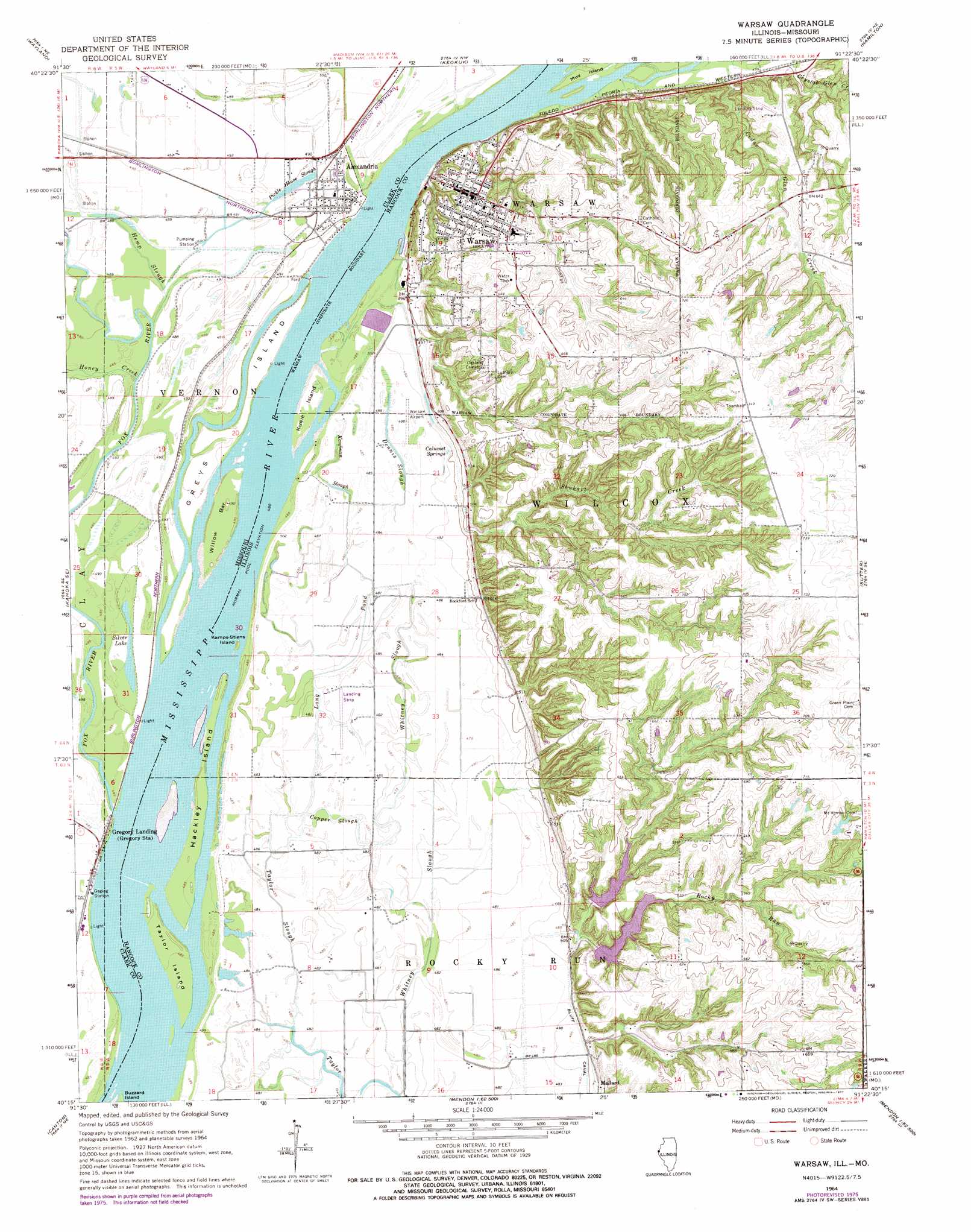
Warsaw Topo Map Illinois
To zoom in, hover over the map of Warsaw
USGS Topo Quad 40091c4 - 1:24,000 scale
| Topo Map Name: | Warsaw |
| USGS Topo Quad ID: | 40091c4 |
| Print Size: | ca. 21 1/4" wide x 27" high |
| Southeast Coordinates: | 40.25° N latitude / 91.375° W longitude |
| Map Center Coordinates: | 40.3125° N latitude / 91.4375° W longitude |
| U.S. States: | IL, MO |
| Filename: | o40091c4.jpg |
| Download Map JPG Image: | Warsaw topo map 1:24,000 scale |
| Map Type: | Topographic |
| Topo Series: | 7.5´ |
| Map Scale: | 1:24,000 |
| Source of Map Images: | United States Geological Survey (USGS) |
| Alternate Map Versions: |
Warsaw IL 1964, updated 1966 Download PDF Buy paper map Warsaw IL 1964, updated 1970 Download PDF Buy paper map Warsaw IL 1964, updated 1977 Download PDF Buy paper map Warsaw IL 2012 Download PDF Buy paper map Warsaw IL 2015 Download PDF Buy paper map |
1:24,000 Topo Quads surrounding Warsaw
Croton |
Argyle |
Nauvoo |
Niota |
Colusa |
Kahoka |
Wayland |
Keokuk |
Hamilton |
Carthage West |
Saint Patrick |
Kahoka Se |
Warsaw |
Sutter |
West Point |
Benjamin |
Canton |
Lima |
Tioga |
Loraine |
Monticello |
La Grange |
Long Island |
Mendon |
Coatsburg |
> Back to 40091a1 at 1:100,000 scale
> Back to 40090a1 at 1:250,000 scale
> Back to U.S. Topo Maps home
Warsaw topo map: Gazetteer
Warsaw: Airports
H Meeker Airport elevation 147m 482′Warsaw Airport elevation 148m 485′
Warsaw: Bars
Willow Bar elevation 149m 488′Warsaw: Dams
Fishback Lake Dam elevation 205m 672′Limkemann Pond Dam elevation 209m 685′
Little Rocky Run Lake Dam elevation 159m 521′
Pickens Lake Dam elevation 148m 485′
Rocky Run Lake Dam elevation 172m 564′
Warsaw: Guts
Copper Slough elevation 145m 475′Dennis Slough elevation 145m 475′
Hemp Slough elevation 149m 488′
Kaufman Slough elevation 146m 479′
Long Pond elevation 145m 475′
Pickle House Slough elevation 148m 485′
Taylor Slough elevation 144m 472′
Whitney Slough elevation 145m 475′
Warsaw: Islands
Fox Island (historical) elevation 147m 482′Greys Island elevation 149m 488′
Hackley Island elevation 149m 488′
Kamps-Stiens Island elevation 147m 482′
Kusie Island elevation 149m 488′
Taylor Island elevation 149m 488′
Warsaw: Lakes
Mud Slough (historical) elevation 146m 479′Silver Lake elevation 147m 482′
Warsaw: Parks
Cedar Glen Nature Preserve elevation 196m 643′Mississippi River Sand Hills Nature Preserve elevation 156m 511′
Warsaw Historic District elevation 176m 577′
Warsaw: Populated Places
Alexandria elevation 149m 488′Gregory Landing elevation 147m 482′
Warsaw elevation 177m 580′
Warsaw: Reservoirs
Limkemann Pond elevation 209m 685′Little Rocky Run Lake elevation 159m 521′
Rocky Run Lake elevation 172m 564′
Warsaw: Springs
Calumet Springs elevation 148m 485′Warsaw: Streams
Fox River elevation 147m 482′Honey Creek elevation 146m 479′
Rocky Run elevation 155m 508′
Shuhart Creek elevation 148m 485′
Warsaw digital topo map on disk
Buy this Warsaw topo map showing relief, roads, GPS coordinates and other geographical features, as a high-resolution digital map file on DVD: