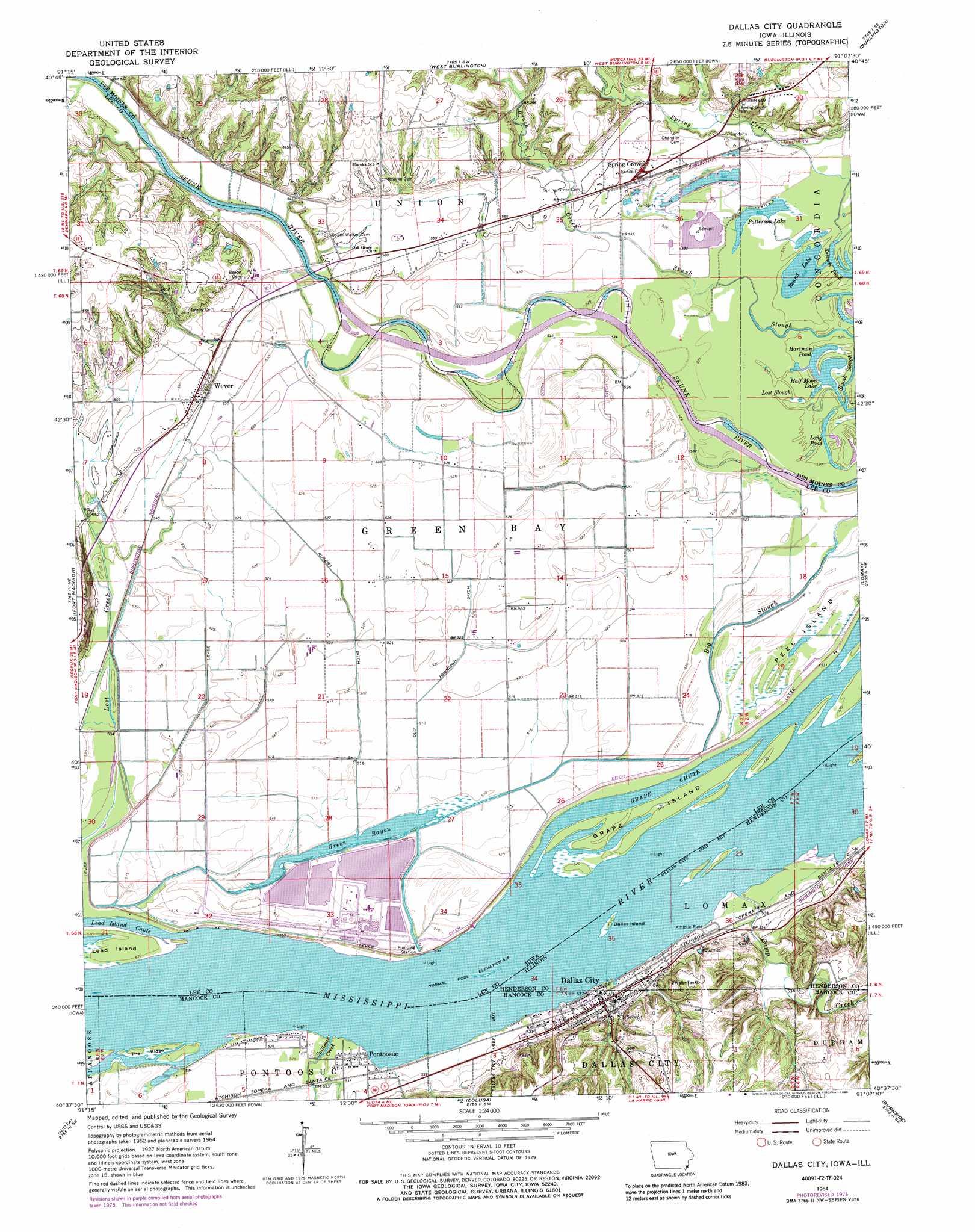
Dallas City Topo Map Iowa
To zoom in, hover over the map of Dallas City
USGS Topo Quad 40091f2 - 1:24,000 scale
| Topo Map Name: | Dallas City |
| USGS Topo Quad ID: | 40091f2 |
| Print Size: | ca. 21 1/4" wide x 27" high |
| Southeast Coordinates: | 40.625° N latitude / 91.125° W longitude |
| Map Center Coordinates: | 40.6875° N latitude / 91.1875° W longitude |
| U.S. States: | IA, IL |
| Filename: | o40091f2.jpg |
| Download Map JPG Image: | Dallas City topo map 1:24,000 scale |
| Map Type: | Topographic |
| Topo Series: | 7.5´ |
| Map Scale: | 1:24,000 |
| Source of Map Images: | United States Geological Survey (USGS) |
| Alternate Map Versions: |
Dallas City IL 1964, updated 1965 Download PDF Buy paper map Dallas City IL 1964, updated 1975 Download PDF Buy paper map Dallas City IL 1964, updated 1977 Download PDF Buy paper map Dallas City IL 1964, updated 1986 Download PDF Buy paper map Dallas City IL 2010 Download PDF Buy paper map Dallas City IL 2012 Download PDF Buy paper map Dallas City IL 2015 Download PDF Buy paper map |
1:24,000 Topo Quads surrounding Dallas City
New London |
Pleasant Grove |
Sperry |
Kingston |
Oquawka |
Lowell |
Danville |
West Burlington |
Burlington |
Gladstone |
West Point |
Fort Madison |
Dallas City |
Lomax |
Stronghurst |
Nauvoo |
Niota |
Colusa |
Burnside |
La Harpe |
Keokuk |
Hamilton |
Carthage West |
Carthage East |
Fountain Green |
> Back to 40091e1 at 1:100,000 scale
> Back to 40090a1 at 1:250,000 scale
> Back to U.S. Topo Maps home
Dallas City topo map: Gazetteer
Dallas City: Canals
Old Township Ditch elevation 158m 518′Rogers Ditch elevation 160m 524′
Dallas City: Guts
Green Bayou elevation 155m 508′Dallas City: Islands
Dallas Island elevation 159m 521′Grape Island elevation 159m 521′
Lead Island elevation 157m 515′
Peel Island elevation 158m 518′
The Ridge elevation 160m 524′
Dallas City: Lakes
Half Moon Lake elevation 159m 521′Hartman Pond elevation 158m 518′
Long Pond elevation 159m 521′
Lost Slough elevation 159m 521′
Patterson Lake elevation 159m 521′
Roscum Pond elevation 159m 521′
Round Lake elevation 159m 521′
Dallas City: Mines
Dallas City Quarry elevation 175m 574′Dallas City: Parks
Blackhawk Bottoms elevation 159m 521′Burk's Run Wildlife Area elevation 164m 538′
Indian Path Park elevation 181m 593′
Dallas City: Populated Places
Dallas City elevation 166m 544′Patterson elevation 166m 544′
Pontoosuc elevation 162m 531′
Skunk River elevation 169m 554′
Spring Grove elevation 171m 561′
Wever elevation 173m 567′
Dallas City: Post Offices
Jollyville Post Office (historical) elevation 202m 662′Wever Post Office elevation 173m 567′
Dallas City: Streams
Big Slough elevation 154m 505′Brush Creek elevation 161m 528′
Camp Creek elevation 159m 521′
Grape Chute elevation 159m 521′
Long Creek elevation 162m 531′
Opossum Creek elevation 161m 528′
Spillman Creek elevation 159m 521′
Dallas City: Summits
Jollyville Hill elevation 162m 531′Dallas City digital topo map on disk
Buy this Dallas City topo map showing relief, roads, GPS coordinates and other geographical features, as a high-resolution digital map file on DVD: