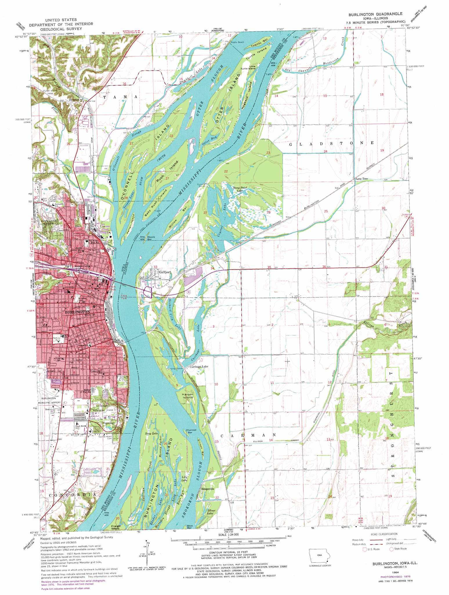
Burlington Topo Map Illinois
To zoom in, hover over the map of Burlington
USGS Topo Quad 40091g1 - 1:24,000 scale
| Topo Map Name: | Burlington |
| USGS Topo Quad ID: | 40091g1 |
| Print Size: | ca. 21 1/4" wide x 27" high |
| Southeast Coordinates: | 40.75° N latitude / 91° W longitude |
| Map Center Coordinates: | 40.8125° N latitude / 91.0625° W longitude |
| U.S. States: | IL, IA |
| Filename: | o40091g1.jpg |
| Download Map JPG Image: | Burlington topo map 1:24,000 scale |
| Map Type: | Topographic |
| Topo Series: | 7.5´ |
| Map Scale: | 1:24,000 |
| Source of Map Images: | United States Geological Survey (USGS) |
| Alternate Map Versions: |
Burlington IA 1964, updated 1965 Download PDF Buy paper map Burlington IA 1964, updated 1972 Download PDF Buy paper map Burlington IA 1964, updated 1977 Download PDF Buy paper map Burlington IA 2010 Download PDF Buy paper map Burlington IA 2013 Download PDF Buy paper map Burlington IA 2015 Download PDF Buy paper map |
1:24,000 Topo Quads surrounding Burlington
Morning Sun |
Mediapolis |
Oakville |
Keithsburg |
Seaton |
Pleasant Grove |
Sperry |
Kingston |
Oquawka |
Rozetta |
Danville |
West Burlington |
Burlington |
Gladstone |
Kirkwood West |
Fort Madison |
Dallas City |
Lomax |
Stronghurst |
Raritan |
Niota |
Colusa |
Burnside |
La Harpe |
Blandinsville |
> Back to 40091e1 at 1:100,000 scale
> Back to 40090a1 at 1:250,000 scale
> Back to U.S. Topo Maps home
Burlington topo map: Gazetteer
Burlington: Airports
Burlington Medical Center Emergency Medical Heliport elevation 183m 600′Burlington: Bars
Charcoal Bar elevation 160m 524′Ellison Bar elevation 160m 524′
Moore Bar elevation 160m 524′
Willow Bar elevation 161m 528′
Burlington: Basins
Mooney Pocket elevation 159m 521′Burlington: Bays
Otter Bay elevation 160m 524′Burlington: Bridges
Cascade Bridge elevation 185m 606′MacArthur Bridge elevation 160m 524′
Sixth Street Viaduct elevation 169m 554′
Burlington: Canals
Ellison Creek Diverson Ditch elevation 160m 524′Burlington: Channels
Jordan Chute elevation 155m 508′Burlington: Guts
Bass Run elevation 159m 521′Marsden Slough elevation 159m 521′
Sullivan Slough elevation 159m 521′
Burlington: Islands
Baby Rush Island elevation 163m 534′Fetter Island elevation 160m 524′
Harper Island elevation 160m 524′
Hogback Island elevation 161m 528′
Little Turtle Island elevation 161m 528′
O'connell Island elevation 160m 524′
Otter Island elevation 160m 524′
Rush Island elevation 160m 524′
Trienes Bar elevation 160m 524′
Turtle Island elevation 161m 528′
Burlington: Lakes
Carthage Lake elevation 156m 511′Crystal Lake elevation 159m 521′
Dumbbell Lake elevation 157m 515′
Lily Lake elevation 159m 521′
Long Lake elevation 159m 521′
Orchard City Lake elevation 157m 515′
Rhodes Lake elevation 159m 521′
Silver Lake elevation 159m 521′
Snag Lake elevation 160m 524′
Stony Point Lake elevation 160m 524′
Yeager Lake elevation 160m 524′
Burlington: Parks
Black Hawk Springs Historical Marker elevation 209m 685′Bradwell Stadium elevation 181m 593′
Clark Fieldhouse elevation 177m 580′
Crapo Park elevation 210m 688′
First Legislative Assembly of Iowa Territory Historical Marker elevation 171m 561′
Flint Hills Park elevation 200m 656′
James Wilson Grimes Homesite Historical Marker elevation 211m 692′
Lieutenant Zebulon Pike's Landing Historical Marker elevation 209m 685′
Mosquito Park elevation 198m 649′
Perkins Park elevation 211m 692′
Riverwalk Park elevation 163m 534′
Seven Revolutionary Soldiers Buried in Des Moines County Historical Museum elevation 170m 557′
Solar Eclipse of 1869 Historical Marker elevation 206m 675′
Burlington: Populated Places
Burlington elevation 185m 606′Carthage Lake elevation 159m 521′
Green Acres Mobile Home Park elevation 166m 544′
Gulfport elevation 159m 521′
Heapsville elevation 160m 524′
Lone Tree elevation 162m 531′
Silver Lake (historical) elevation 161m 528′
Burlington: Post Offices
Burlington Post Office elevation 165m 541′Crystal Springs Golf Club Post Office (historical) elevation 207m 679′
The Willow Patch Post Office (historical) elevation 160m 524′
Burlington: Streams
Dry Branch elevation 160m 524′Ellison Creek elevation 159m 521′
Flint Creek elevation 160m 524′
O'Connell Slough elevation 160m 524′
Otter Slough elevation 160m 524′
Rush Chute elevation 160m 524′
Burlington digital topo map on disk
Buy this Burlington topo map showing relief, roads, GPS coordinates and other geographical features, as a high-resolution digital map file on DVD: