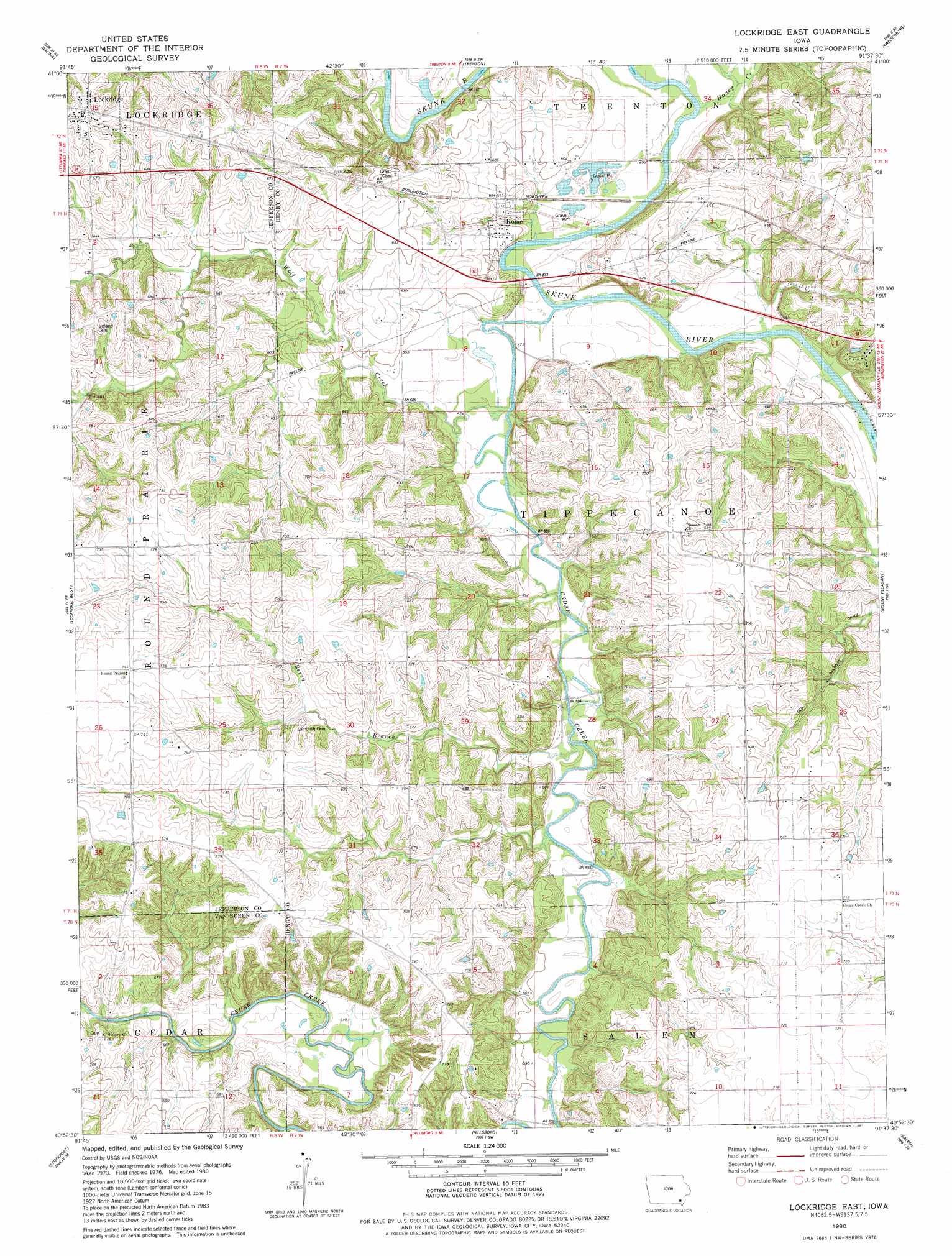
Lockridge East Topo Map Iowa
To zoom in, hover over the map of Lockridge East
USGS Topo Quad 40091h6 - 1:24,000 scale
| Topo Map Name: | Lockridge East |
| USGS Topo Quad ID: | 40091h6 |
| Print Size: | ca. 21 1/4" wide x 27" high |
| Southeast Coordinates: | 40.875° N latitude / 91.625° W longitude |
| Map Center Coordinates: | 40.9375° N latitude / 91.6875° W longitude |
| U.S. State: | IA |
| Filename: | o40091h6.jpg |
| Download Map JPG Image: | Lockridge East topo map 1:24,000 scale |
| Map Type: | Topographic |
| Topo Series: | 7.5´ |
| Map Scale: | 1:24,000 |
| Source of Map Images: | United States Geological Survey (USGS) |
| Alternate Map Versions: |
Lockridge East IA 1980, updated 1981 Download PDF Buy paper map Lockridge East IA 2010 Download PDF Buy paper map Lockridge East IA 2013 Download PDF Buy paper map Lockridge East IA 2015 Download PDF Buy paper map |
1:24,000 Topo Quads surrounding Lockridge East
Richland |
Brighton |
Wayland |
Crawfordsville |
Winfield North |
Fairfield North |
Salina |
Trenton |
Swedesburg |
Winfield South |
Fairfield South |
Lockridge West |
Lockridge East |
Mount Pleasant |
New London |
Mount Zion |
Stockport |
Hillsboro |
Salem |
Lowell |
Keosauqua |
Bonaparte |
Farmington |
Donnellson |
West Point |
> Back to 40091e1 at 1:100,000 scale
> Back to 40090a1 at 1:250,000 scale
> Back to U.S. Topo Maps home
Lockridge East topo map: Gazetteer
Lockridge East: Parks
Gibson Recreation Area elevation 174m 570′O'Laughlin Recreation Wildlife Area elevation 177m 580′
Lockridge East: Populated Places
Belfast (historical) elevation 188m 616′Denova elevation 218m 715′
Lockridge elevation 222m 728′
Rome elevation 182m 597′
Lockridge East: Post Offices
Denova Post Office (historical) elevation 218m 715′Finis Post Office (historical) elevation 216m 708′
Lockridge Post Office elevation 219m 718′
Rome Post Office (historical) elevation 182m 597′
Vega Post Office (historical) elevation 198m 649′
Vega Post Office (historical) elevation 215m 705′
Lockridge East: Streams
Berry Branch elevation 177m 580′Cedar Creek Church elevation 218m 715′
Honey Creek elevation 174m 570′
Wolf Creek elevation 174m 570′
Lockridge East digital topo map on disk
Buy this Lockridge East topo map showing relief, roads, GPS coordinates and other geographical features, as a high-resolution digital map file on DVD: