Le Roy Topo Map Iowa
To zoom in, hover over the map of Le Roy
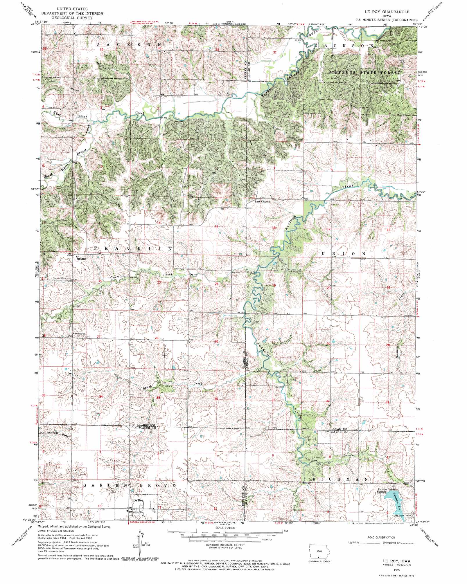
USGS Topo Quad 40093h5 - 1:24,000 scale
| Topo Map Name: | Le Roy |
| USGS Topo Quad ID: | 40093h5 |
| Print Size: | ca. 21 1/4" wide x 27" high |
| Southeast Coordinates: | 40.875° N latitude / 93.5° W longitude |
| Map Center Coordinates: | 40.9375° N latitude / 93.5625° W longitude |
| U.S. State: | IA |
| Filename: | o40093h5.jpg |
| Download Map JPG Image: | Le Roy topo map 1:24,000 scale |
| Map Type: | Topographic |
| Topo Series: | 7.5´ |
| Map Scale: | 1:24,000 |
| Source of Map Images: | United States Geological Survey (USGS) |
| Alternate Map Versions: |
Le Roy IA 1965, updated 1966 Download PDF Buy paper map Le Roy IA 2010 Download PDF Buy paper map Le Roy IA 2013 Download PDF Buy paper map Le Roy IA 2015 Download PDF Buy paper map |
1:24,000 Topo Quads surrounding Le Roy
Truro |
New Virginia |
Medora |
Lacona |
Newbern |
Osceola |
Jamison |
Woodburn |
Lucas |
Chariton |
Lacelle |
Weldon |
Le Roy |
Derby |
Corydon Ne |
Van Wert |
Garden Grove Sw |
Garden Grove |
Humeston |
Corydon |
Davis City |
Leon |
Woodland |
Clio |
Allerton |
> Back to 40093e1 at 1:100,000 scale
> Back to 40092a1 at 1:250,000 scale
> Back to U.S. Topo Maps home
Le Roy topo map: Gazetteer
Le Roy: Forests
Stephens State Forest - White Breast Unit elevation 321m 1053′Le Roy: Parks
Humeston Park elevation 332m 1089′Le Roy: Populated Places
Last Chance elevation 328m 1076′Le Roy elevation 340m 1115′
Smyrna elevation 334m 1095′
Le Roy: Post Offices
Last Chance Post Office (historical) elevation 328m 1076′Le Roy Post Office (historical) elevation 340m 1115′
Selma Post Office (historical) elevation 334m 1095′
Smyrna Post Office (historical) elevation 334m 1095′
Le Roy: Reservoirs
Humeston Reservoir elevation 327m 1072′Le Roy: Streams
Brush Creek elevation 311m 1020′Chariton Creek elevation 308m 1010′
South White Breast Creek elevation 283m 928′
Le Roy digital topo map on disk
Buy this Le Roy topo map showing relief, roads, GPS coordinates and other geographical features, as a high-resolution digital map file on DVD: