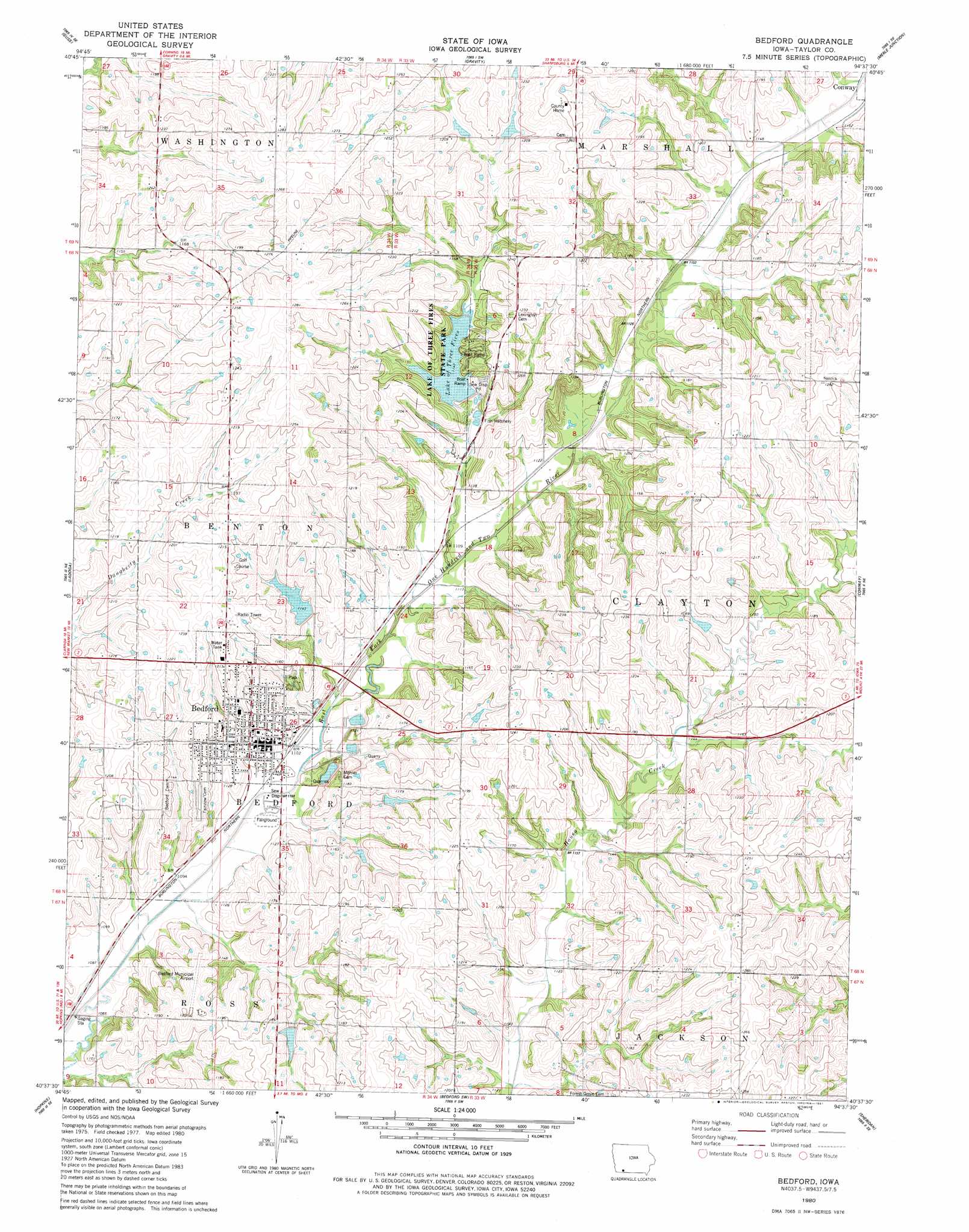
Bedford Topo Map Iowa
To zoom in, hover over the map of Bedford
USGS Topo Quad 40094f6 - 1:24,000 scale
| Topo Map Name: | Bedford |
| USGS Topo Quad ID: | 40094f6 |
| Print Size: | ca. 21 1/4" wide x 27" high |
| Southeast Coordinates: | 40.625° N latitude / 94.625° W longitude |
| Map Center Coordinates: | 40.6875° N latitude / 94.6875° W longitude |
| U.S. State: | IA |
| Filename: | o40094f6.jpg |
| Download Map JPG Image: | Bedford topo map 1:24,000 scale |
| Map Type: | Topographic |
| Topo Series: | 7.5´ |
| Map Scale: | 1:24,000 |
| Source of Map Images: | United States Geological Survey (USGS) |
| Alternate Map Versions: |
Bedford IA 1980, updated 1981 Download PDF Buy paper map Bedford IA 2010 Download PDF Buy paper map Bedford IA 2013 Download PDF Buy paper map Bedford IA 2015 Download PDF Buy paper map |
1:24,000 Topo Quads surrounding Bedford
Villisca |
Brooks |
Corning South |
Lenox |
Kent |
Hawleyville |
Guss |
Gravity |
Merle Junction |
Clearfield |
New Market |
Ladoga |
Bedford |
Conway |
Maloy |
Hopkins Sw |
Hopkins |
Bedford Sw |
Sheridan |
Blockton |
Wilcox |
Pickering |
Parnell West |
Parnell East |
Grant City |
> Back to 40094e1 at 1:100,000 scale
> Back to 40094a1 at 1:250,000 scale
> Back to U.S. Topo Maps home
Bedford topo map: Gazetteer
Bedford: Airports
Bedford Municipal Airport elevation 364m 1194′Bedford: Dams
Bedford Water Supply Dam elevation 348m 1141′Lake of the Three Fires Dam elevation 341m 1118′
Bedford: Lakes
Lake of Three Fires elevation 348m 1141′Bedford: Parks
Bedford City Park elevation 346m 1135′Lake Binder Park elevation 348m 1141′
Lake of Three Fires State Park elevation 348m 1141′
Simmons Tract Park elevation 365m 1197′
Bedford: Populated Places
Bedford elevation 344m 1128′Bedford: Post Offices
Bedford Post Office elevation 344m 1128′Harmony Post Office (historical) elevation 352m 1154′
Lexington Post Office (historical) elevation 356m 1167′
Bedford: Reservoirs
Bedford Water Supply Lake elevation 348m 1141′Lake of the Three Fires elevation 341m 1118′
Bedford digital topo map on disk
Buy this Bedford topo map showing relief, roads, GPS coordinates and other geographical features, as a high-resolution digital map file on DVD: