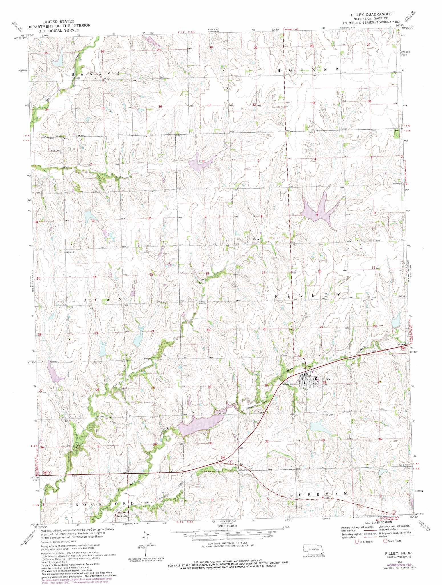
Filley Topo Map Nebraska
To zoom in, hover over the map of Filley
USGS Topo Quad 40096c5 - 1:24,000 scale
| Topo Map Name: | Filley |
| USGS Topo Quad ID: | 40096c5 |
| Print Size: | ca. 21 1/4" wide x 27" high |
| Southeast Coordinates: | 40.25° N latitude / 96.5° W longitude |
| Map Center Coordinates: | 40.3125° N latitude / 96.5625° W longitude |
| U.S. State: | NE |
| Filename: | O40096c5.jpg |
| Download Map JPG Image: | Filley topo map 1:24,000 scale |
| Map Type: | Topographic |
| Topo Series: | 7.5´ |
| Map Scale: | 1:24,000 |
| Source of Map Images: | United States Geological Survey (USGS) |
| Alternate Map Versions: |
Filley NE 1970, updated 1972 Download PDF Buy paper map Filley NE 1970, updated 1980 Download PDF Buy paper map Filley NE 2011 Download PDF Buy paper map Filley NE 2014 Download PDF Buy paper map |
1:24,000 Topo Quads surrounding Filley
Hallam |
Cortland |
Firth |
Douglas |
Burr |
Clatonia |
Pickrell |
Adams |
Sterling |
Saint Mary |
Beatrice West |
Beatrice East |
Filley |
Crab Orchard |
Vesta |
Odell Ne |
Blue Springs |
Wymore Ne |
Lewiston |
Burchard |
Odell |
Wymore |
Barneston |
Liberty |
Liberty Se |
> Back to 40096a1 at 1:100,000 scale
> Back to 40096a1 at 1:250,000 scale
> Back to U.S. Topo Maps home
Filley topo map: Gazetteer
Filley: Dams
Bear Creek Dam 7-C elevation 423m 1387′Bear Creek Dam 7-D elevation 412m 1351′
Bear Creek Dam 8-B elevation 419m 1374′
Bear Creek Dam 8-C elevation 424m 1391′
Cedar Creek Dam 9-A elevation 424m 1391′
Cedar Creek Dam 9-B elevation 416m 1364′
Cedar Creek Dam 9-C elevation 415m 1361′
Cedar Creek Dam 9-E elevation 416m 1364′
Cedar Creek Dam 9-F elevation 421m 1381′
Mud Creek Dam 2-A elevation 409m 1341′
Mud Creek Dam 2-C elevation 433m 1420′
Mud Creek Dam 5-1 elevation 439m 1440′
Mud Creek Dam 5-A elevation 428m 1404′
Filley: Parks
Iron Horse Trail State Wildlife Management Area elevation 425m 1394′Filley: Populated Places
Filley elevation 428m 1404′Rockford elevation 408m 1338′
Filley: Post Offices
Filley Post Office elevation 428m 1404′Rockford Post Office (historical) elevation 408m 1338′
Filley: Reservoirs
Bear Creek Reservoir 7-C elevation 423m 1387′Bear Creek Reservoir 7-D elevation 412m 1351′
Bear Creek Reservoir 8-B elevation 419m 1374′
Bear Creek Reservoir 8-C elevation 424m 1391′
Cedar Creek Reservoir 9-A elevation 424m 1391′
Cedar Creek Reservoir 9-B elevation 416m 1364′
Cedar Creek Reservoir 9-C elevation 415m 1361′
Cedar Creek Reservoir 9-E elevation 416m 1364′
Cedar Creek Reservoir 9-F elevation 421m 1381′
Mud Creek Reservoir 2-A elevation 409m 1341′
Mud Creek Reservoir 2-C elevation 433m 1420′
Mud Creek Reservoir 5-1 elevation 439m 1440′
Mud Creek Reservoir 5-A elevation 428m 1404′
Filley digital topo map on disk
Buy this Filley topo map showing relief, roads, GPS coordinates and other geographical features, as a high-resolution digital map file on DVD: