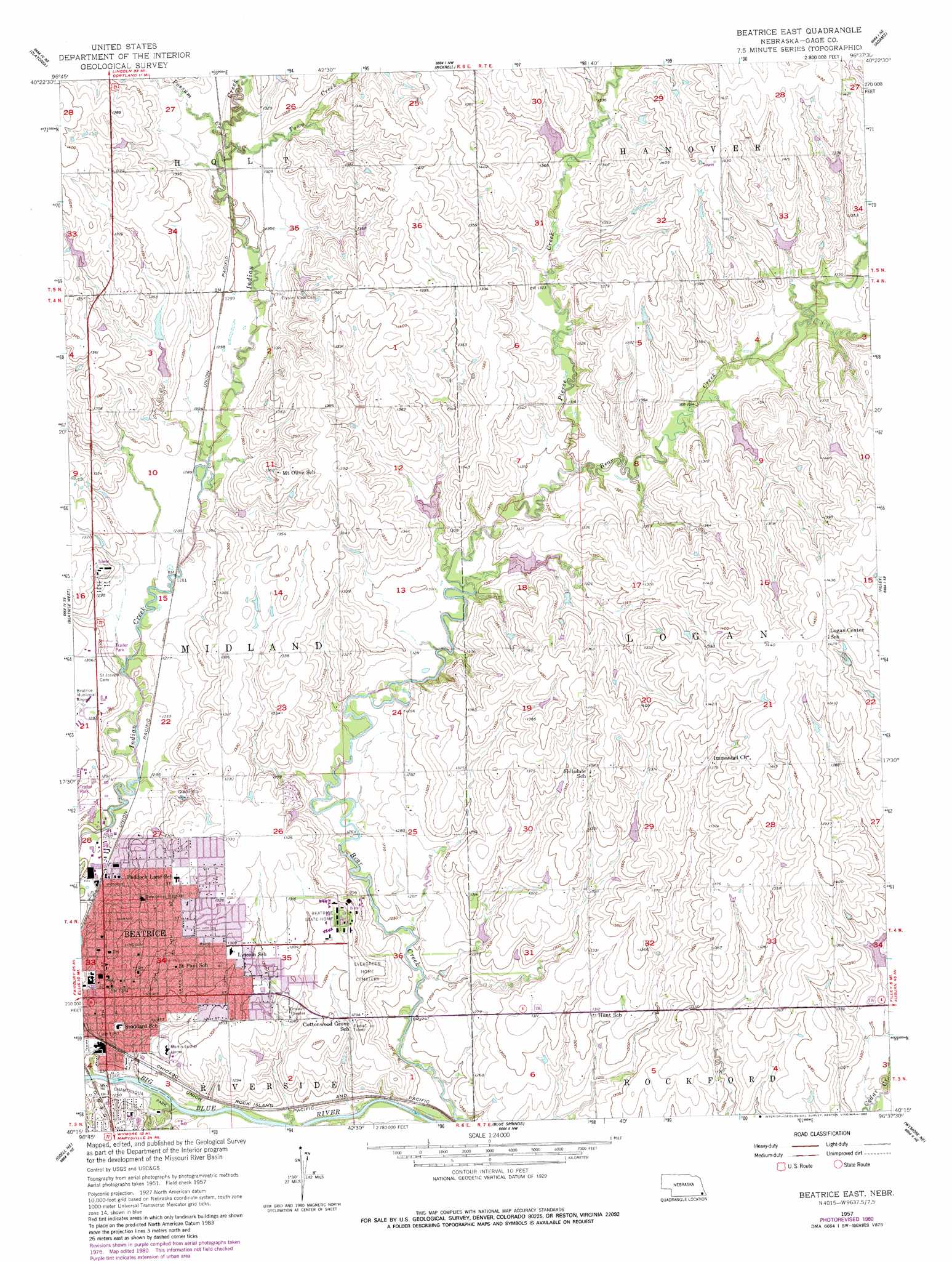
Beatrice East Topo Map Nebraska
To zoom in, hover over the map of Beatrice East
USGS Topo Quad 40096c6 - 1:24,000 scale
| Topo Map Name: | Beatrice East |
| USGS Topo Quad ID: | 40096c6 |
| Print Size: | ca. 21 1/4" wide x 27" high |
| Southeast Coordinates: | 40.25° N latitude / 96.625° W longitude |
| Map Center Coordinates: | 40.3125° N latitude / 96.6875° W longitude |
| U.S. State: | NE |
| Filename: | O40096c6.jpg |
| Download Map JPG Image: | Beatrice East topo map 1:24,000 scale |
| Map Type: | Topographic |
| Topo Series: | 7.5´ |
| Map Scale: | 1:24,000 |
| Source of Map Images: | United States Geological Survey (USGS) |
| Alternate Map Versions: |
Beatrice East NE 1957, updated 1959 Download PDF Buy paper map Beatrice East NE 1957, updated 1980 Download PDF Buy paper map Beatrice East NE 2011 Download PDF Buy paper map Beatrice East NE 2014 Download PDF Buy paper map |
1:24,000 Topo Quads surrounding Beatrice East
Crete South |
Hallam |
Cortland |
Firth |
Douglas |
Wilber |
Clatonia |
Pickrell |
Adams |
Sterling |
Plymouth |
Beatrice West |
Beatrice East |
Filley |
Crab Orchard |
Harbine |
Odell Ne |
Blue Springs |
Wymore Ne |
Lewiston |
Diller |
Odell |
Wymore |
Barneston |
Liberty |
> Back to 40096a1 at 1:100,000 scale
> Back to 40096a1 at 1:250,000 scale
> Back to U.S. Topo Maps home
Beatrice East topo map: Gazetteer
Beatrice East: Dams
Barnard Dam elevation 401m 1315′Bear Creek Dam 2-1 elevation 411m 1348′
Bear Creek Dam 2-A elevation 396m 1299′
Bear Creek Dam 2-B elevation 393m 1289′
Bear Creek Dam 6-2 elevation 414m 1358′
Bear Creek Dam 6-3 elevation 414m 1358′
Bear Creek Dam 6-A elevation 412m 1351′
Bear Creek Dam 6-B elevation 401m 1315′
Cedar Creek Dam 9-D elevation 401m 1315′
Indian Creek Dam 11-A elevation 398m 1305′
Pierce Creek Dam 3-A elevation 407m 1335′
Beatrice East: Parks
Astro Park elevation 404m 1325′Charles Park elevation 391m 1282′
Chautauqua Park elevation 376m 1233′
Hannibal Park Softball Complex elevation 403m 1322′
Homestead Movement Historical Marker elevation 398m 1305′
Robertson Park elevation 393m 1289′
Beatrice East: Populated Places
Beatrice elevation 392m 1286′Hoyle North 77 Mobile Homes elevation 392m 1286′
Beatrice East: Post Offices
Beatrice Post Office elevation 394m 1292′Beatrice East: Reservoirs
Barnard Reservoir elevation 401m 1315′Bear Creek Reservoir 2-1 elevation 411m 1348′
Bear Creek Reservoir 2-A elevation 396m 1299′
Bear Creek Reservoir 2-B elevation 393m 1289′
Bear Creek Reservoir 6-2 elevation 414m 1358′
Bear Creek Reservoir 6-3 elevation 414m 1358′
Bear Creek Reservoir 6-A elevation 412m 1351′
Bear Creek Reservoir 6-B elevation 401m 1315′
Cedar Creek Reservoir 9-D elevation 401m 1315′
Indian Creek Reservoir 11-A elevation 398m 1305′
Pierce Creek Reservoir 3-A elevation 407m 1335′
Beatrice East: Streams
Crystal Creek elevation 375m 1230′Pierce Creek elevation 392m 1286′
Possum Creek elevation 394m 1292′
Town Creek elevation 395m 1295′
Beatrice East digital topo map on disk
Buy this Beatrice East topo map showing relief, roads, GPS coordinates and other geographical features, as a high-resolution digital map file on DVD: