Beatrice West Topo Map Nebraska
To zoom in, hover over the map of Beatrice West
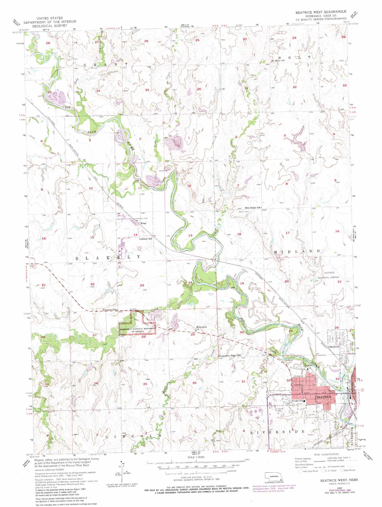
USGS Topo Quad 40096c7 - 1:24,000 scale
| Topo Map Name: | Beatrice West |
| USGS Topo Quad ID: | 40096c7 |
| Print Size: | ca. 21 1/4" wide x 27" high |
| Southeast Coordinates: | 40.25° N latitude / 96.75° W longitude |
| Map Center Coordinates: | 40.3125° N latitude / 96.8125° W longitude |
| U.S. State: | NE |
| Filename: | O40096c7.jpg |
| Download Map JPG Image: | Beatrice West topo map 1:24,000 scale |
| Map Type: | Topographic |
| Topo Series: | 7.5´ |
| Map Scale: | 1:24,000 |
| Source of Map Images: | United States Geological Survey (USGS) |
| Alternate Map Versions: |
Beatrice West NE 1957, updated 1958 Download PDF Buy paper map Beatrice West NE 1957, updated 1980 Download PDF Buy paper map Beatrice West NE 2011 Download PDF Buy paper map Beatrice West NE 2014 Download PDF Buy paper map |
1:24,000 Topo Quads surrounding Beatrice West
Pleasant Hill |
Crete South |
Hallam |
Cortland |
Firth |
Swanton |
Wilber |
Clatonia |
Pickrell |
Adams |
Western Se |
Plymouth |
Beatrice West |
Beatrice East |
Filley |
Jansen |
Harbine |
Odell Ne |
Blue Springs |
Wymore Ne |
Endicott |
Diller |
Odell |
Wymore |
Barneston |
> Back to 40096a1 at 1:100,000 scale
> Back to 40096a1 at 1:250,000 scale
> Back to U.S. Topo Maps home
Beatrice West topo map: Gazetteer
Beatrice West: Airports
Beatrice Municipal Airport elevation 398m 1305′Beatrice West: Dams
Cub Creek Dam G-1 elevation 399m 1309′Cub Creek Dam G-6 elevation 407m 1335′
Dusenbery-Doyle Dam elevation 378m 1240′
Ebbers Dam Number 1 elevation 410m 1345′
Beatrice West: Parks
Beatrice Speedway elevation 398m 1305′Christenson Field elevation 387m 1269′
Homestead National Monument of America elevation 386m 1266′
Nichols Park elevation 379m 1243′
Riverside Park elevation 381m 1250′
Roszell Park elevation 389m 1276′
Shrine Park elevation 381m 1250′
Beatrice West: Populated Places
Glenover elevation 388m 1272′Hoag elevation 387m 1269′
Beatrice West: Post Offices
Hoag Post Office (historical) elevation 387m 1269′Beatrice West: Reservoirs
Cub Creek Reservoir G-1 elevation 399m 1309′Cub Creek Reservoir G-6 elevation 407m 1335′
Dusenbery-Doyle Reservoir elevation 378m 1240′
Ebbers Reservoir Number 1 elevation 410m 1345′
Beatrice West: Streams
Bottle Creek elevation 376m 1233′Cub Creek elevation 379m 1243′
Indian Creek elevation 378m 1240′
Snake Creek elevation 380m 1246′
Snake Creek elevation 381m 1250′
Soap Creek elevation 383m 1256′
Beatrice West: Trails
Homestead Trail elevation 387m 1269′Beatrice West digital topo map on disk
Buy this Beatrice West topo map showing relief, roads, GPS coordinates and other geographical features, as a high-resolution digital map file on DVD: