Firth Topo Map Nebraska
To zoom in, hover over the map of Firth
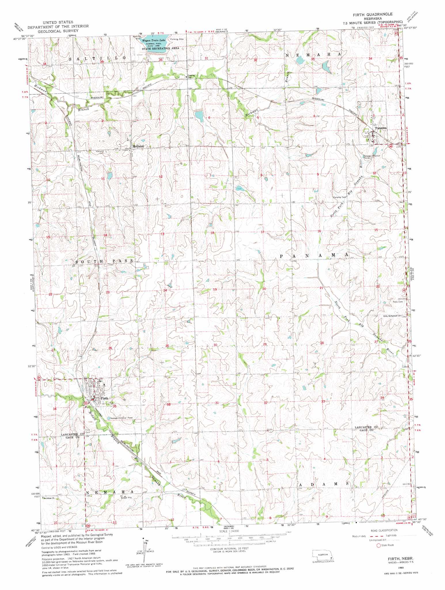
USGS Topo Quad 40096e5 - 1:24,000 scale
| Topo Map Name: | Firth |
| USGS Topo Quad ID: | 40096e5 |
| Print Size: | ca. 21 1/4" wide x 27" high |
| Southeast Coordinates: | 40.5° N latitude / 96.5° W longitude |
| Map Center Coordinates: | 40.5625° N latitude / 96.5625° W longitude |
| U.S. State: | NE |
| Filename: | O40096e5.jpg |
| Download Map JPG Image: | Firth topo map 1:24,000 scale |
| Map Type: | Topographic |
| Topo Series: | 7.5´ |
| Map Scale: | 1:24,000 |
| Source of Map Images: | United States Geological Survey (USGS) |
| Alternate Map Versions: |
Firth NE 1965, updated 1966 Download PDF Buy paper map Firth NE 2011 Download PDF Buy paper map Firth NE 2014 Download PDF Buy paper map |
1:24,000 Topo Quads surrounding Firth
Emerald |
Lincoln |
Walton |
Eagle |
Elmwood |
Denton |
Roca |
Bennet |
Palmyra |
Unadilla |
Hallam |
Cortland |
Firth |
Douglas |
Burr |
Clatonia |
Pickrell |
Adams |
Sterling |
Saint Mary |
Beatrice West |
Beatrice East |
Filley |
Crab Orchard |
Vesta |
> Back to 40096e1 at 1:100,000 scale
> Back to 40096a1 at 1:250,000 scale
> Back to U.S. Topo Maps home
Firth topo map: Gazetteer
Firth: Airports
Liesveld Airport elevation 419m 1374′Firth: Dams
Big Nemaha Dam 11-A elevation 407m 1335′Big Nemaha Dam L-4 elevation 414m 1358′
N F Big Nemaha Dam 23-B elevation 400m 1312′
N F Big Nemaha Dam 23-C elevation 399m 1309′
N F Big Nemaha Dam 23-D elevation 401m 1315′
Salt Creek Dam 10-4 elevation 408m 1338′
Salt Creek Dam 10-A elevation 394m 1292′
Salt Creek Dam 11-A elevation 398m 1305′
Salt Creek Dam 38-3 elevation 412m 1351′
Salt Creek Dam 38-A elevation 405m 1328′
Upper Big Nemaha Dam L-17 elevation 412m 1351′
Upper Big Nemaha Dam L-5 elevation 414m 1358′
Upper Salt Creek Dam 11-4 elevation 398m 1305′
Van Pelt Dam elevation 409m 1341′
Wagon Train Dam-Site 8 Dam elevation 392m 1286′
Firth: Parks
Hedgefield State Wildlife Management Area elevation 391m 1282′Firth: Populated Places
Firth elevation 404m 1325′Holland elevation 415m 1361′
Panama elevation 425m 1394′
Pella (historical) elevation 413m 1354′
Firth: Post Offices
Firth Post Office elevation 404m 1325′Holland Post Office elevation 415m 1361′
Panama Post Office elevation 425m 1394′
Pella Post Office (historical) elevation 413m 1354′
Firth: Reservoirs
Big Nemaha Reservoir 11-A elevation 407m 1335′Big Nemaha Reservoir 6-4 elevation 414m 1358′
Hedgefield Reservoir elevation 394m 1292′
N F Big Nemaha Reservoir 23-B elevation 400m 1312′
N F Big Nemaha Reservoir 23-C elevation 399m 1309′
N F Big Nemaha Reservoir 23-D elevation 401m 1315′
Salt Creek Reservoir 10-4 elevation 408m 1338′
Salt Creek Reservoir 11-A elevation 398m 1305′
Salt Creek Reservoir 38-3 elevation 412m 1351′
Salt Creek Reservoir 38-A elevation 405m 1328′
Upper Big Nemaha Reservoir L-17 elevation 412m 1351′
Upper Big Nemaha Reservoir L-5 elevation 414m 1358′
Upper Salt Creek Reservoir 11-4 elevation 398m 1305′
Van Pelt Reservoir elevation 409m 1341′
Wagon Train Lake elevation 391m 1282′
Firth digital topo map on disk
Buy this Firth topo map showing relief, roads, GPS coordinates and other geographical features, as a high-resolution digital map file on DVD: