Syracuse Topo Map Nebraska
To zoom in, hover over the map of Syracuse
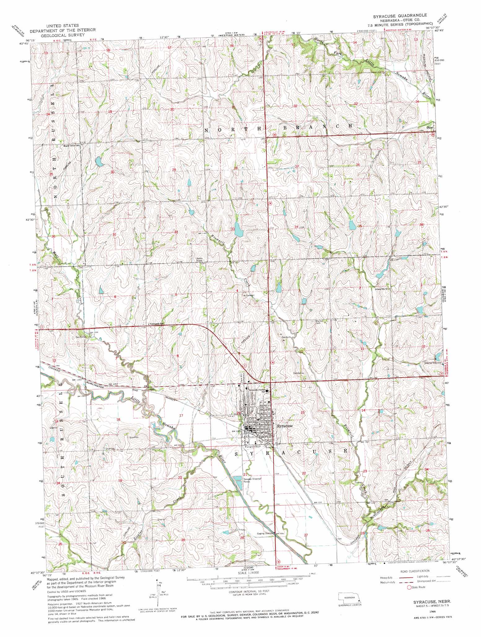
USGS Topo Quad 40096f2 - 1:24,000 scale
| Topo Map Name: | Syracuse |
| USGS Topo Quad ID: | 40096f2 |
| Print Size: | ca. 21 1/4" wide x 27" high |
| Southeast Coordinates: | 40.625° N latitude / 96.125° W longitude |
| Map Center Coordinates: | 40.6875° N latitude / 96.1875° W longitude |
| U.S. State: | NE |
| Filename: | O40096f2.jpg |
| Download Map JPG Image: | Syracuse topo map 1:24,000 scale |
| Map Type: | Topographic |
| Topo Series: | 7.5´ |
| Map Scale: | 1:24,000 |
| Source of Map Images: | United States Geological Survey (USGS) |
| Alternate Map Versions: |
Syracuse NE 1966, updated 1968 Download PDF Buy paper map Syracuse NE 2012 Download PDF Buy paper map Syracuse NE 2014 Download PDF Buy paper map |
1:24,000 Topo Quads surrounding Syracuse
Greenwood |
Murdock |
Manley |
Weeping Water Ne |
Murray |
Eagle |
Elmwood |
Weeping Water |
Avoca |
Nehawka |
Palmyra |
Unadilla |
Syracuse |
Dunbar |
Nebraska City Nw |
Douglas |
Burr |
Cook |
Talmage |
Paul |
Sterling |
Saint Mary |
Tecumseh Nw |
Tecumseh Ne |
Brock |
> Back to 40096e1 at 1:100,000 scale
> Back to 40096a1 at 1:250,000 scale
> Back to U.S. Topo Maps home
Syracuse topo map: Gazetteer
Syracuse: Airports
Syracuse Hospital Heliport elevation 342m 1122′Syracuse: Dams
Brehm Dam elevation 342m 1122′Brownell Creek Dam 10-2 elevation 320m 1049′
Brownell Creek Dam 11-6 elevation 345m 1131′
Brownell Creek Dam 11-A elevation 355m 1164′
Brownell Creek Dam 12-3 elevation 363m 1190′
Brownell Creek Dam 12-A elevation 356m 1167′
Brownell Creek Dam 1-4 elevation 363m 1190′
Brownell Creek Dam 1-A elevation 349m 1145′
Brownell Creek Dam 2-A elevation 341m 1118′
Brownell Creek Dam 3-6 elevation 331m 1085′
Brownell Creek Dam 6-A elevation 348m 1141′
Brownell Creek Dam 7-A elevation 357m 1171′
Brownell Creek Dam 8-3 elevation 369m 1210′
Brownell Creek Dam 8-A elevation 358m 1174′
Brownell Creek Dam 9-A elevation 356m 1167′
Fargo Dam elevation 350m 1148′
Janeke Dam elevation 368m 1207′
Wilson Creek Dam 9-1 elevation 344m 1128′
Wilson Creek Dam 9-6 elevation 367m 1204′
Wilson Creek Dam 9-C elevation 354m 1161′
Ziegler Creek Dam Z-1 elevation 335m 1099′
Ziegler Creek Dam Z-15 elevation 334m 1095′
Ziegler Creek Dam Z-16 elevation 321m 1053′
Ziegler Creek Dam Z-17 elevation 327m 1072′
Syracuse: Parks
Nebraska City - Fort Kearney Cutoff Historical Marker elevation 339m 1112′Syracuse: Populated Places
Syracuse elevation 320m 1049′Syracuse: Post Offices
Syracuse Post Office elevation 330m 1082′Syracuse: Reservoirs
Brehm Reservoir elevation 342m 1122′Brownell Creek Reservoir 10-2 elevation 320m 1049′
Brownell Creek Reservoir 11-6 elevation 345m 1131′
Brownell Creek Reservoir 11-A elevation 355m 1164′
Brownell Creek Reservoir 12-3 elevation 363m 1190′
Brownell Creek Reservoir 12-A elevation 356m 1167′
Brownell Creek Reservoir 1-4 elevation 363m 1190′
Brownell Creek Reservoir 1-A elevation 349m 1145′
Brownell Creek Reservoir 2-4 elevation 341m 1118′
Brownell Creek Reservoir 3-6 elevation 331m 1085′
Brownell Creek Reservoir 6-A elevation 348m 1141′
Brownell Creek Reservoir 7-A elevation 357m 1171′
Brownell Creek Reservoir 8-3 elevation 369m 1210′
Brownell Creek Reservoir 8-A elevation 358m 1174′
Chase Hoppe Reservoir 9-A elevation 356m 1167′
Fargo Reservoir elevation 350m 1148′
Janeke Reservoir elevation 368m 1207′
Wilson Creek Reservoir 9-1 elevation 344m 1128′
Wilson Creek Reservoir 9-6 elevation 367m 1204′
Wilson Creek Reservoir 9-C elevation 354m 1161′
Ziegler Creek Reservoir Z-1 elevation 335m 1099′
Ziegler Creek Reservoir Z-15 elevation 334m 1095′
Ziegler Creek Reservoir Z-16 elevation 321m 1053′
Ziegler Creek Reservoir Z-17 elevation 327m 1072′
Syracuse: Streams
Wolf Creek elevation 310m 1017′Ziegler Creek elevation 307m 1007′
Syracuse digital topo map on disk
Buy this Syracuse topo map showing relief, roads, GPS coordinates and other geographical features, as a high-resolution digital map file on DVD: