Denton Topo Map Nebraska
To zoom in, hover over the map of Denton
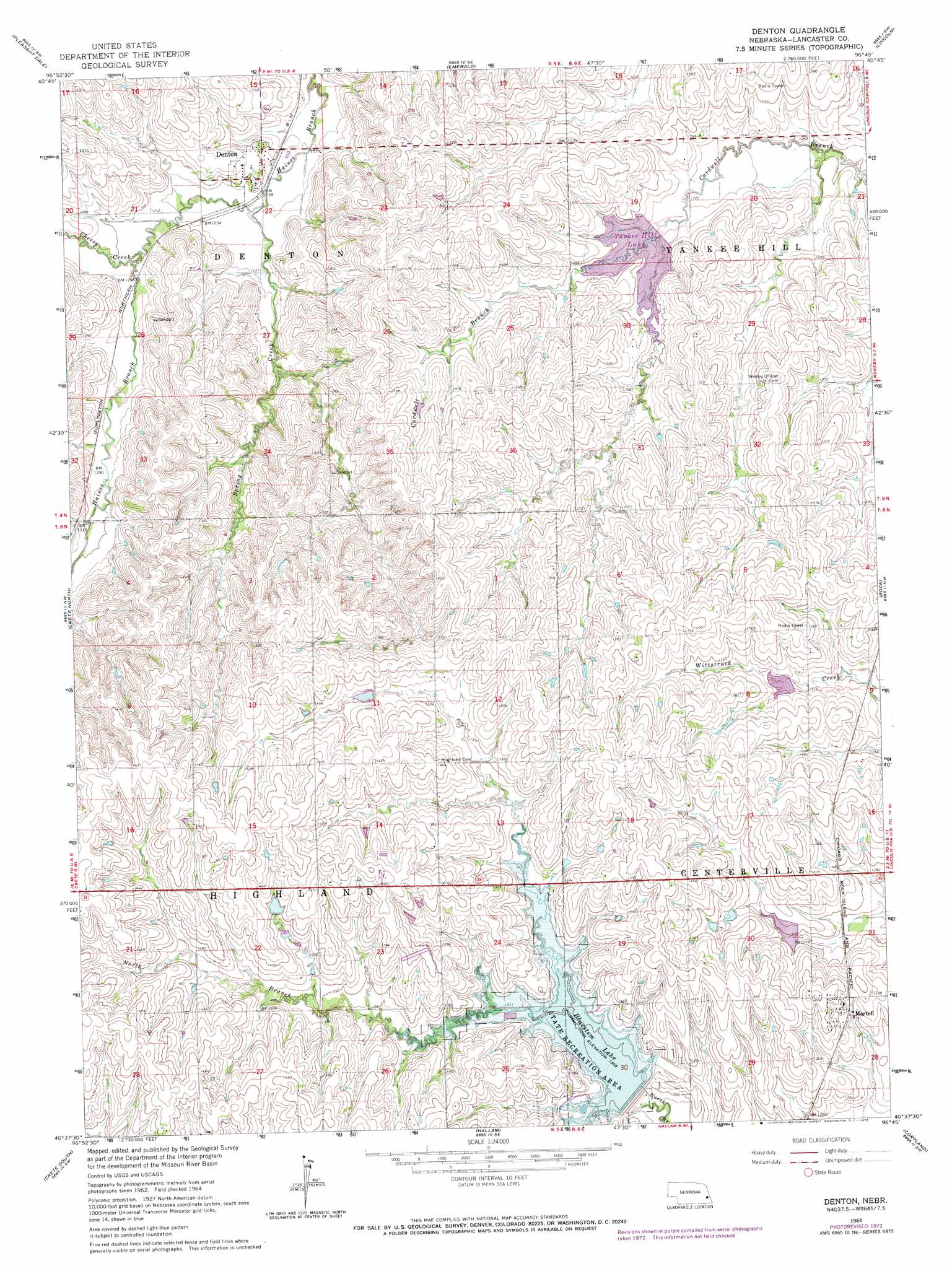
USGS Topo Quad 40096f7 - 1:24,000 scale
| Topo Map Name: | Denton |
| USGS Topo Quad ID: | 40096f7 |
| Print Size: | ca. 21 1/4" wide x 27" high |
| Southeast Coordinates: | 40.625° N latitude / 96.75° W longitude |
| Map Center Coordinates: | 40.6875° N latitude / 96.8125° W longitude |
| U.S. State: | NE |
| Filename: | O40096f7.jpg |
| Download Map JPG Image: | Denton topo map 1:24,000 scale |
| Map Type: | Topographic |
| Topo Series: | 7.5´ |
| Map Scale: | 1:24,000 |
| Source of Map Images: | United States Geological Survey (USGS) |
| Alternate Map Versions: |
Denton NE 1964, updated 1965 Download PDF Buy paper map Denton NE 1964, updated 1973 Download PDF Buy paper map Denton NE 2011 Download PDF Buy paper map Denton NE 2014 Download PDF Buy paper map |
1:24,000 Topo Quads surrounding Denton
Seward |
Garland |
Raymond |
Davey |
Waverly |
Milford |
Pleasant Dale |
Emerald |
Lincoln |
Walton |
Dorchester |
Crete North |
Denton |
Roca |
Bennet |
Pleasant Hill |
Crete South |
Hallam |
Cortland |
Firth |
Swanton |
Wilber |
Clatonia |
Pickrell |
Adams |
> Back to 40096e1 at 1:100,000 scale
> Back to 40096a1 at 1:250,000 scale
> Back to U.S. Topo Maps home
Denton topo map: Gazetteer
Denton: Airports
Brusnahan Airport elevation 388m 1272′Denton: Dams
Bluestem Dam-Site 4 Dam elevation 397m 1302′Brandt Dam elevation 394m 1292′
Salt Creek Dam 16-A elevation 400m 1312′
Salt Creek Dam 17-A elevation 393m 1289′
Salt Creek Dam 23-B elevation 423m 1387′
Yankee Hill Dam-Site 10 Dam elevation 375m 1230′
Denton: Parks
Bluestem Lake State Recreation Area elevation 397m 1302′Civilian Conservation Corps Co 2738 Historical Marker elevation 380m 1246′
Killdeer Lake State Wildlife Management Area elevation 403m 1322′
Yankee Hill State Wildlife Management Area elevation 379m 1243′
Denton: Populated Places
Denton elevation 380m 1246′Martell elevation 405m 1328′
Denton: Post Offices
Denton Post Office elevation 380m 1246′Martell Post Office elevation 405m 1328′
Denton: Reservoirs
Bluestem Lake elevation 397m 1302′Brandt Reservoir elevation 394m 1292′
Killdeer Lake elevation 400m 1312′
Salt Creek Reservoir 16-A elevation 400m 1312′
Salt Creek Reservoir 17-A elevation 393m 1289′
Salt Creek Reservoir 23-B elevation 423m 1387′
Yankee Hill Lake elevation 372m 1220′
Denton: Streams
Cheese Creek elevation 378m 1240′North Branch Salt Creek elevation 402m 1318′
Spring Creek elevation 372m 1220′
Denton digital topo map on disk
Buy this Denton topo map showing relief, roads, GPS coordinates and other geographical features, as a high-resolution digital map file on DVD: