Fairbury Topo Map Nebraska
To zoom in, hover over the map of Fairbury
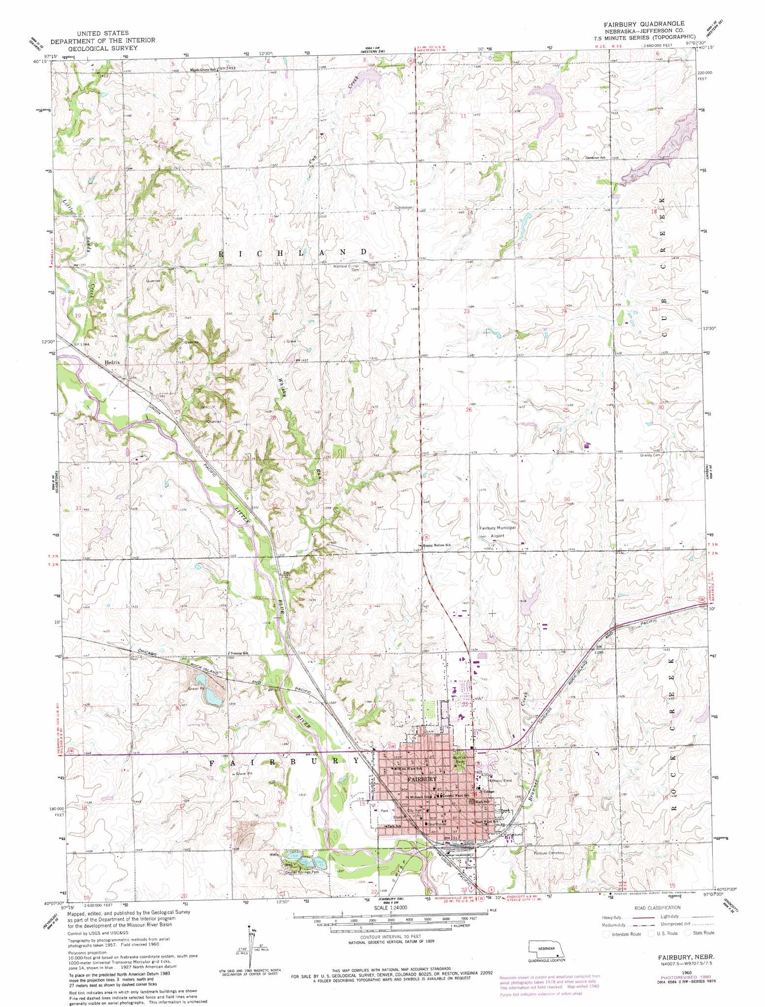
USGS Topo Quad 40097b2 - 1:24,000 scale
| Topo Map Name: | Fairbury |
| USGS Topo Quad ID: | 40097b2 |
| Print Size: | ca. 21 1/4" wide x 27" high |
| Southeast Coordinates: | 40.125° N latitude / 97.125° W longitude |
| Map Center Coordinates: | 40.1875° N latitude / 97.1875° W longitude |
| U.S. State: | NE |
| Filename: | O40097b2.jpg |
| Download Map JPG Image: | Fairbury topo map 1:24,000 scale |
| Map Type: | Topographic |
| Topo Series: | 7.5´ |
| Map Scale: | 1:24,000 |
| Source of Map Images: | United States Geological Survey (USGS) |
| Alternate Map Versions: |
Fairbury NE 1960, updated 1962 Download PDF Buy paper map Fairbury NE 1960, updated 1980 Download PDF Buy paper map Fairbury NE 2011 Download PDF Buy paper map Fairbury NE 2014 Download PDF Buy paper map |
1:24,000 Topo Quads surrounding Fairbury
Ohiowa |
Tobias |
Western |
Swanton |
Wilber |
Tobias Sw |
Daykin |
Western Sw |
Western Se |
Plymouth |
Alexandria |
Gladstone |
Fairbury |
Jansen |
Harbine |
Hubbell |
Reynolds |
Fairbury Sw |
Endicott |
Diller |
Narka |
Mahaska |
Washington Nw |
Washington Ne |
Hanover West |
> Back to 40097a1 at 1:100,000 scale
> Back to 40096a1 at 1:250,000 scale
> Back to U.S. Topo Maps home
Fairbury topo map: Gazetteer
Fairbury: Airports
Fairbury Municipal Airport elevation 447m 1466′Jefferson County Memorial Hospital Heliport elevation 437m 1433′
Fairbury: Dams
Cub Creek Dam 17-B elevation 442m 1450′Davis Dam elevation 438m 1437′
Floodwater Retarding Dam 16-B elevation 430m 1410′
Frederick Dam elevation 430m 1410′
Rudolph E Glaeseman Detention Dam elevation 427m 1400′
Fairbury: Parks
Crystal Springs Park elevation 406m 1332′McNush Park elevation 423m 1387′
Smith Limekiln Historical Marker elevation 402m 1318′
Fairbury: Populated Places
Fairbury elevation 404m 1325′Hedrix elevation 413m 1354′
Fairbury: Post Offices
Fairbury Post Office elevation 403m 1322′Fairbury: Reservoirs
Cub Creek Reservoir 16-B elevation 430m 1410′Cub Creek Reservoir 17-B elevation 442m 1450′
Davis Reservoir elevation 438m 1437′
Frederick Reservoir elevation 430m 1410′
Glaeseman Reservoir elevation 427m 1400′
Fairbury: Streams
Little Sandy Creek elevation 404m 1325′Whisky Run elevation 402m 1318′
Fairbury digital topo map on disk
Buy this Fairbury topo map showing relief, roads, GPS coordinates and other geographical features, as a high-resolution digital map file on DVD: