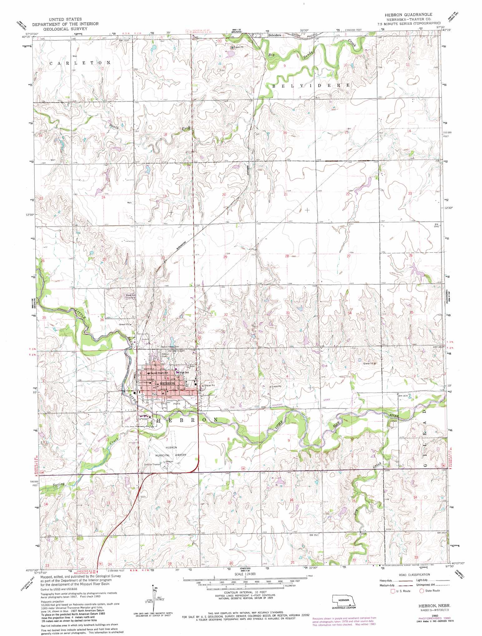
Hebron Topo Map Nebraska
To zoom in, hover over the map of Hebron
USGS Topo Quad 40097b5 - 1:24,000 scale
| Topo Map Name: | Hebron |
| USGS Topo Quad ID: | 40097b5 |
| Print Size: | ca. 21 1/4" wide x 27" high |
| Southeast Coordinates: | 40.125° N latitude / 97.5° W longitude |
| Map Center Coordinates: | 40.1875° N latitude / 97.5625° W longitude |
| U.S. State: | NE |
| Filename: | O40097b5.jpg |
| Download Map JPG Image: | Hebron topo map 1:24,000 scale |
| Map Type: | Topographic |
| Topo Series: | 7.5´ |
| Map Scale: | 1:24,000 |
| Source of Map Images: | United States Geological Survey (USGS) |
| Alternate Map Versions: |
Hebron NE 1960, updated 1962 Download PDF Buy paper map Hebron NE 1960, updated 1980 Download PDF Buy paper map Hebron NE 2011 Download PDF Buy paper map Hebron NE 2014 Download PDF Buy paper map |
1:24,000 Topo Quads surrounding Hebron
Ong |
Shickley |
Strang |
Ohiowa |
Tobias |
Davenport |
Carleton |
Bruning |
Tobias Sw |
Daykin |
Ruskin |
Deshler |
Hebron |
Alexandria |
Gladstone |
Byron |
Hebron Sw |
Chester |
Hubbell |
Reynolds |
Republic |
Belleville Nw |
Munden |
Narka |
Mahaska |
> Back to 40097a1 at 1:100,000 scale
> Back to 40096a1 at 1:250,000 scale
> Back to U.S. Topo Maps home
Hebron topo map: Gazetteer
Hebron: Airports
Dog Leg Airport elevation 477m 1564′Hebron Municipal Airport elevation 445m 1459′
Hebron: Dams
Dondlinger Dam elevation 453m 1486′Elting Dam elevation 463m 1519′
Hebron Dam elevation 458m 1502′
Hebron: Parks
Legion Field elevation 443m 1453′Little Blue State Wildlife Management Area elevation 434m 1423′
Riverside Park elevation 444m 1456′
Roosevelt Park elevation 445m 1459′
Willard Park elevation 445m 1459′
Hebron: Populated Places
Hebron elevation 448m 1469′Hebron: Post Offices
Hebron Post Office elevation 447m 1466′Hebron: Reservoirs
Dondlinger Reservoir elevation 453m 1486′Elting Reservoir elevation 463m 1519′
Hebron Reservoir elevation 458m 1502′
Hebron: Streams
Dry Creek elevation 433m 1420′South Fork Big Sandy Creek elevation 448m 1469′
Spring Creek elevation 439m 1440′
Hebron digital topo map on disk
Buy this Hebron topo map showing relief, roads, GPS coordinates and other geographical features, as a high-resolution digital map file on DVD: