Fairmont Topo Map Nebraska
To zoom in, hover over the map of Fairmont
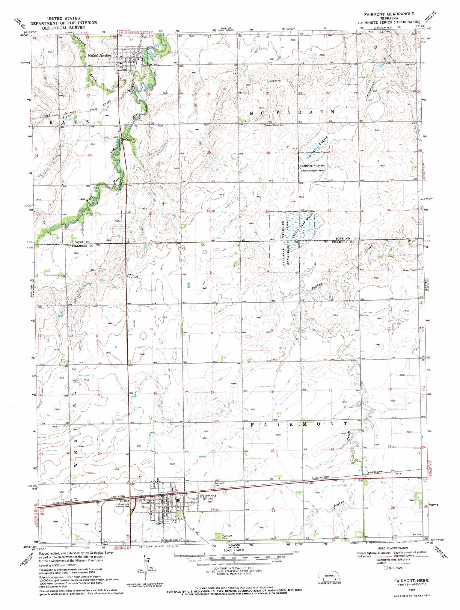
USGS Topo Quad 40097f5 - 1:24,000 scale
| Topo Map Name: | Fairmont |
| USGS Topo Quad ID: | 40097f5 |
| Print Size: | ca. 21 1/4" wide x 27" high |
| Southeast Coordinates: | 40.625° N latitude / 97.5° W longitude |
| Map Center Coordinates: | 40.6875° N latitude / 97.5625° W longitude |
| U.S. State: | NE |
| Filename: | O40097f5.jpg |
| Download Map JPG Image: | Fairmont topo map 1:24,000 scale |
| Map Type: | Topographic |
| Topo Series: | 7.5´ |
| Map Scale: | 1:24,000 |
| Source of Map Images: | United States Geological Survey (USGS) |
| Alternate Map Versions: |
Fairmont NE 1969, updated 1971 Download PDF Buy paper map Fairmont NE 2011 Download PDF Buy paper map Fairmont NE 2014 Download PDF Buy paper map |
1:24,000 Topo Quads surrounding Fairmont
Henderson Ne |
Bradshaw |
York North |
Waco |
Utica |
Henderson |
York Sw |
York South |
Utica Sw |
Beaver Crossing |
Bixby |
Grafton |
Fairmont |
Exeter |
Friend |
Sutton |
Geneva Sw |
Geneva |
Friend Sw |
Friend Se |
Ong |
Shickley |
Strang |
Ohiowa |
Tobias |
> Back to 40097e1 at 1:100,000 scale
> Back to 40096a1 at 1:250,000 scale
> Back to U.S. Topo Maps home
Fairmont topo map: Gazetteer
Fairmont: Dams
Weiss Road Dam elevation 488m 1601′Fairmont: Parks
County Line Federal Waterfowl Production Area elevation 487m 1597′Crosstrails Wayside Park elevation 503m 1650′
Fairmont Army Air Field Historical Marker elevation 507m 1663′
Fairmont Creamery Company Historical Marker elevation 500m 1640′
Real Federal Waterfowl Production Area elevation 498m 1633′
Sinninger Federal Waterfowl Production Area elevation 495m 1624′
Fairmont: Populated Places
Fairmont elevation 500m 1640′McCool Junction elevation 476m 1561′
Fairmont: Post Offices
Fairmont Post Office elevation 500m 1640′McCool Junction Post Office elevation 474m 1555′
Fairmont: Reservoirs
Weiss Reservoir elevation 488m 1601′Fairmont: Streams
Galaway Creek elevation 469m 1538′Stone Creek elevation 468m 1535′
Fairmont: Swamps
County Line Marsh elevation 486m 1594′Sininger Lagoon elevation 486m 1594′
Fairmont digital topo map on disk
Buy this Fairmont topo map showing relief, roads, GPS coordinates and other geographical features, as a high-resolution digital map file on DVD: